METAR & TAF KCNH
KCNH does not publish a METAR.
Showing the nearest reporting station: KVSF (HARTNESS STATE (SPRINGFIELD)) · 6.7 NM away. Conditions at KCNH may differ.
METAR · KVSF
Observed 14:54Z
KVSF 271454Z AUTO 00000KT 10SM CLR 24/15 A2986 RMK AO2 SLP108 T02440150 56007
- Wind
- 000° @ 0 kt
- Visibility
- 10 SM
- Temp / Dew
- 24°C / 15°C
- Altimeter
- 29.86 inHg
- Clouds
- CLR
- Density alt
- 1,828 ft
- Ceiling
- Unlimited
- Rules
- VFR
Airport info & contacts
Manager on record, flight service, ARTCC, attendance schedule and pattern altitude — published by the FAA and refreshed every 28 days.
Location
- From city
- 1 NM W
- VFR sectional
- NEW YORK
- ARTCC
- ZBW · BOSTON
- NOTAM facility
- BGR (NOTAM-D)
Airport manager
- Name
- JAMES CHAMBERLAIN
- Phone
- (603) 542-5156
- Address
- 100 BROAD ST, CLAREMONT NH 03743
Flight service · Hours
- FSS BGR
- BANGOR1-800-WX-BRIEF
- Attendance
- MON-FRI · 1000-1600
Frequencies
Tap any row to copy the frequency to your clipboard.
Runways & pattern
Full pagePattern entry · RWY 11
LEFT TRAFFICRunway end performance
| End | TORA | TODA | ASDA | LDA | VGSI | Approach lights | Obstruction |
|---|---|---|---|---|---|---|---|
| 11 | — | — | — | — | — | — | 226', tree, 2917' from thr, 255' R of cntrln, slope 12 |
| 29 | — | — | — | — | PAPI 2-box left(4°) | — | 32', tree, 731' from thr, 295' R of cntrln, slope 16 |
Declared distances in feet. TORA = takeoff run available, TODA = takeoff distance, ASDA = accelerate-stop, LDA = landing distance.
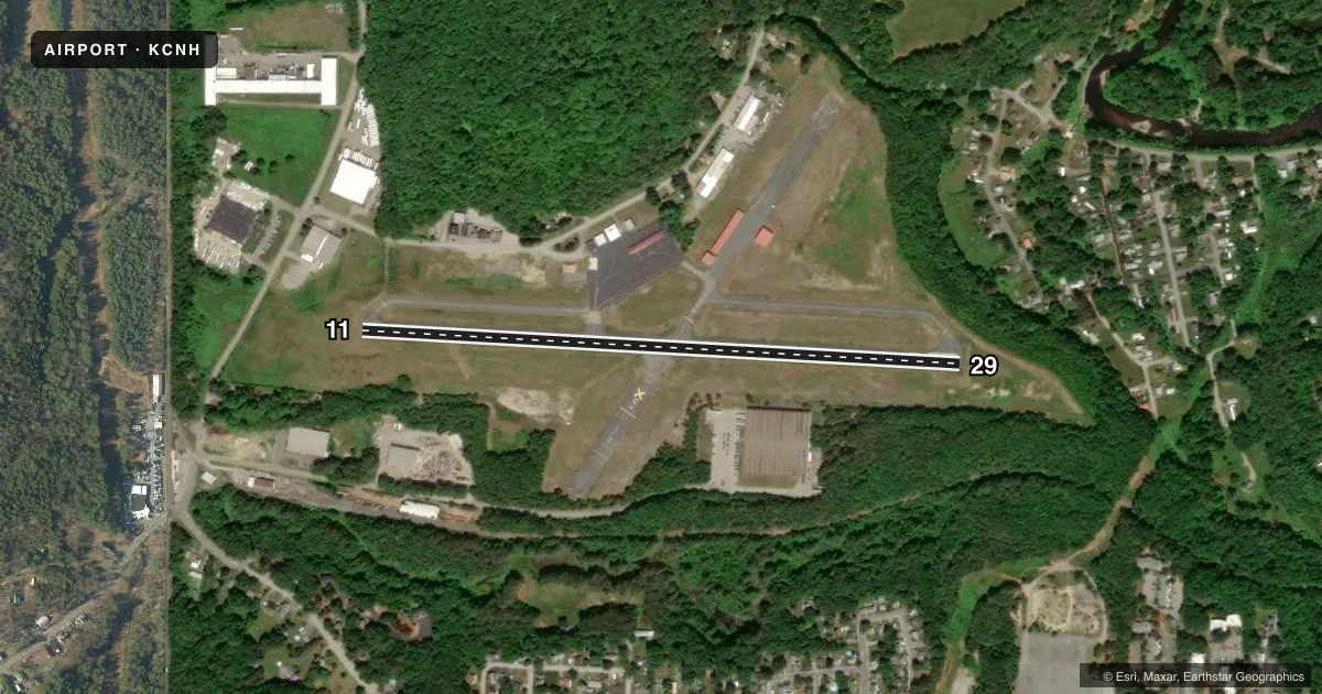
Airport sketch
Runways drawn to scale from FAA survey coordinates, rendered over satellite imagery. Not for navigation.
Approaches & charts
Services on the field
Fuel grades, oxygen, maintenance, ramp storage and lighting — as declared to the FAA by the airport operator.
Fuel & services
- Fuel
- 100LL
- Oxygen (bottled)
- Not available
- Oxygen (bulk)
- Not available
- Airframe repair
- Minor
- Power plant repair
- Minor
- Other services
- AVNCS
Ramp & ground
- Transient storage
- Tie-down
- Landing fee
- No fee published
- Customs
- Not available
- Lighting schedule
- SEE RMK
- Beacon schedule
- SS-SR
- Beacon
- White / Green (civil land)(WG)
- Wind indicator
- Lighted
- Segmented circle
- Yes
Fuel & FBOs
Cheapest 100LL and Jet A on the field and nearby. Always confirm with the FBO before taxi.
Airport notes
Surface conditions, obstructions, local procedures, lighting outages and other notes published with each FAA cycle.
General notes
- HAZ BCNS ON SRNDG HILLS.
- EXPC DOWNDRAFT ON APCH TO RWY 29.
- TKOF, LNDG & TAX ON UNPAVED AREAS PROHIBITED.
- WILDLIFE ON & INVOF ARPT.
- COLD TEMPERATURE AIRPORT. ALTITUDE CORRECTION REQUIRED AT OR BELOW -24C.
- FOR CD CTC BOSTON ARTCC AT 603-879-6859.
Lighting notes
- ROTG BCN DFCLT TO SEE FM THE N WHEN FOLIAGE IS ON THE TREES.
- ACTVT REIL RWY 29; MIRL RWY 11/29 - CTAF.
Fuel notes
- 100LLFUEL SELF SVC 24 HRS BY CREDIT CARD.
Runway surface & condition
- 11/29PCR VALUE: 383/F/A/X/T
Approach & departure obstructions
- 295 FT BRUSH 88 FT R OF CNTRLN.
Other notes
- ESTAB PRIOR TO 1959.
- 1FOR ARPT SVCS, CALL 603-542-2282.
VFR map & nearby airports
VFR sectional. Tap any ICAO chip to open that airport.
Key facts · KCNH
Answer card- ICAO
- KCNH
- Name
- CLAREMONT MUNI
- Location
- CLAREMONT, NEW HAMPSHIRE
- Elevation
- 543.3 ft MSL
- Traffic pattern altitude
- 1,543.3 ft MSL (1,000 AGL)
- Control tower
- Non-towered (use CTAF)
- Total runways
- 1
- Longest runway
- 11/29 · 3,098 ft
- Published ILS approaches
- 0
- Published frequencies
- 2
- Magnetic variation
- 16°
- Current flight rules
- VFR
- Current wind
- 000° at 0 kt
- Favored runway now
- –
Claremont Muni sits in Claremont, New Hampshire. Field elevation is 543.3 ft MSL. The airport has one runway, 11/29, which is 3,098 ft long and asphalt. There is no control tower. CTAF and UNICOM are both 122.7. No ILS approaches are published here, so plan with current weather and the Chart Supplement in hand.
Pattern altitude is not published. Use the standard 1,000 ft AGL pattern for light piston traffic unless local procedures or ATC say otherwise. The field is a cold temperature airport. Altitude correction is required at or below minus 24 degrees Celsius. That matters on winter mornings in New Hampshire.
Claremont Municipal Airport is on the field. It carries 100LL. Self-serve 100LL is available 24 hours by credit card. For airport services, the published phone number is 603-542-2282. Runway 29 has a published downdraft note on approach. There is also brush 88 ft right of centerline near runway 29. Hazard beacons sit on surrounding hills. The rotating beacon can be hard to see from the north when the trees have leaves. Takeoff, landing and taxi on unpaved areas are prohibited. If you need clearance delivery, contact Boston ARTCC at 603-879-6859.