METAR & TAF KRUT
Current METAR
Observed 12:56Z
KRUT 271256Z AUTO 00000KT 10SM 21/15 A2987 RMK AO2 SLP104 T02060150
- Wind
- 000° @ 0 kt
- Visibility
- 10 SM
- Temp / Dew
- 21°C / 15°C
- Altimeter
- 29.87 inHg
- Clouds
- Clear
- Density alt
- 1,758 ft
- Ceiling
- Unlimited
- Rules
- VFR
Airport info & contacts
Manager on record, flight service, ARTCC, attendance schedule and pattern altitude — published by the FAA and refreshed every 28 days.
Location
- From city
- 5 NM S
- VFR sectional
- NEW YORK
- ARTCC
- ZBW · BOSTON
- NOTAM facility
- RUT (NOTAM-D)
Airport manager
- Name
- CHRISTOPHER BEITZEL
- Phone
- 802-272-7725
- Address
- 219 N MAIN ST, BARRE VT 05641
Flight service · Hours
- FSS BTV
- BURLINGTON1-800-WX-BRIEF
- Attendance
- 0700-1930
Frequencies
Tap any row to copy the frequency to your clipboard.
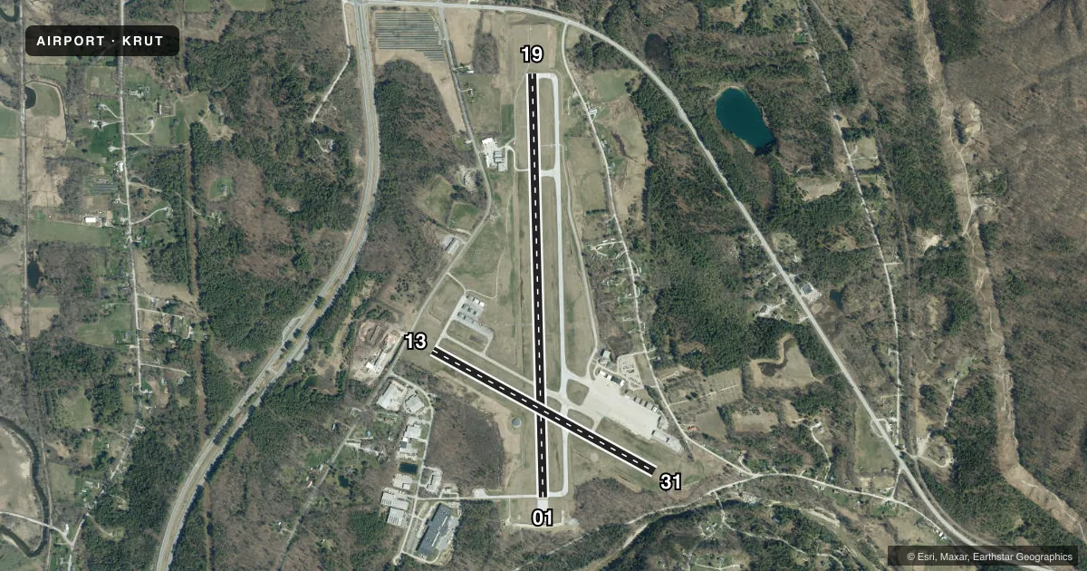
Runways & pattern
Full pagePattern entry · RWY 01
LEFT TRAFFIC| Runway | Heading (°M) | Length | Surface | Traffic |
|---|---|---|---|---|
| 01/19 | 344° / 164° | 5,304 ft | ASPH | 19 R |
| 13/31 | 104° / 284° | 3,169 ft | ASPH | Standard L |
Runway end performance
| End | TORA | TODA | ASDA | LDA | VGSI | Approach lights | Obstruction |
|---|---|---|---|---|---|---|---|
| 01 | 5,304' | 5,304' | 5,304' | 5,004' | PSIR(3.5°) | — | 135', hill, 4800' from thr, slope 34 |
| 19 | 5,004' | 5,004' | 5,004' | 5,004' | PAPI 4-box left(3.2°) | MALSR | — |
| 13 | — | — | — | — | — | — | 16', road, 325' from thr, 0' R of cntrln, slope 7 |
| 31 | — | — | — | — | — | — | 20', trees, 600' from thr, 100' R of cntrln, slope 20 |
Declared distances in feet. TORA = takeoff run available, TODA = takeoff distance, ASDA = accelerate-stop, LDA = landing distance.
Airport sketch
Runways drawn to scale from FAA survey coordinates, rendered over satellite imagery. Not for navigation.
Approaches & charts
ILS · 1
Services on the field
Fuel grades, oxygen, maintenance, ramp storage and lighting — as declared to the FAA by the airport operator.
Fuel & services
- Fuel
- 100LLA
- Oxygen (bottled)
- Not available
- Oxygen (bulk)
- Not available
- Airframe repair
- Major
- Power plant repair
- Major
- Other services
- AFRT,CHTR,INSTR,RNTL,SALES
Ramp & ground
- Transient storage
- Tie-down
- Hangar
- Landing fee
- Yes
- Customs
- Not available
- Lighting schedule
- SEE RMK
- Beacon schedule
- SS-SR
- Beacon
- White / Green (civil land)(WG)
- Wind indicator
- Lighted
- Segmented circle
- Yes
Fuel & FBOs
Cheapest 100LL and Jet A on the field and nearby. Always confirm with the FBO before taxi.
Airport notes
Surface conditions, obstructions, local procedures, lighting outages and other notes published with each FAA cycle.
General notes
- ACFT WITH WING SPANS EXCEEDING 79 FT AUZD TO USE TWY H & TWY B EAST OF RWY 1/19 & RWY 13/31 FOR TAX & RWYS 01 & 19 FOR TKOF & LDG. NOISE SENSITIVE AREA SE OF ARPT CTC AMGR.
- RWY CONDS MAY NOT BE MNT OR RPRTD WHEN ARPT IS UNATNDD.
- TYPE I & TYPE IV DEICING AVBL.
- BIRDS ON & INVOF ARPT.
- COLD TEMPERATURE AIRPORT. ALTITUDE CORRECTION REQUIRED AT OR BELOW -7C.
- USE TWY A TO TAX TO OR FM AER 01 OR 19.
- TWY C CNCTS MAIN APRON WITH TWY A.
- FOR CD CTC BOSTON ARTCC AT 603-879-6859.
Lighting notes
- ACTVT MALSR RWY 19; REIL RWY 13; HIRL RWY 01/19; MIRL RWY 13/31 - CTAF.
Runway surface & condition
- 01/19PCR VALUE: 271/F/D/X/T
- 13/31PCR VALUE: 172/F/D/X/T
- 01/19RWY 01/19 NOT AVBL FOR PART 121/PART 380 OPS WITH SKED PAX CARRYING OPS MORE THAN 9 PAX SEATS AND NON-SKED PAX CARRYING OPS MORE THAN 30 PAX SEATS. 90 DAY PPR FOR UNSKED ACR OPS GTR THAN 30 PAX SEATS - CALL AMGR.
- 13/31RWY 13/31 NOT AVBL FOR PART 121/PART 380 OPS WITH SKED PAX CARRYING OPS MORE THAN 9 PAX SEATS AND NON-SKED PAX CARRYING OPS MORE THAN 30 PAX SEATS. 90 DAY PPR FOR UNSKED ACR OPS GTR THAN 30 PAX SEATS - CALL AMGR.
Approach & departure obstructions
- 01OTS UFN.
Other notes
- EXISTED PRIOR TO 1959.
- ARFF SVC AVBL FOR NON-AIR CARRIER OPS, 48 HR PPR. CTC AMGR.
- LDG FEES MAY APPLY FOR COML ACFT.
- 1FOR AFT HRS SVC CALL 802-773-3348.
VFR map & nearby airports
VFR sectional. Tap any ICAO chip to open that airport.
Key facts · KRUT
Answer card- ICAO
- KRUT
- Name
- RUTLAND/SOUTHERN VERMONT RGNL
- Location
- RUTLAND, VERMONT
- Elevation
- 787.3 ft MSL
- Traffic pattern altitude
- 1,787.3 ft MSL (1,000 AGL)
- Control tower
- Non-towered (use CTAF)
- Total runways
- 2
- Longest runway
- 01/19 · 5,304 ft
- Published ILS approaches
- 1
- Published frequencies
- 2
- Magnetic variation
- 15°
- Current flight rules
- VFR
- Current wind
- 000° at 0 kt
- Favored runway now
- –
KRUT is in Rutland, Vermont. The field elevation is 787.3 ft MSL. It has two asphalt runways. The longest is runway 01/19 at 5,304 ft. There is no control tower, so use CTAF 122.8 for local traffic. The airport has one ILS approach to runway 19. Pattern altitude is not published, so use the standard 1,000 ft AGL for light piston operations unless current local guidance says otherwise.
Modern Aviation is on the field. It carries 100LL and Jet A. Call (802) 773-3348 for current service details. The published remarks also note bird activity on and near the airport. That matters here. Plan your scan on departure and on short final.
A few other items matter for planning. Runway 19 has medium intensity approach lighting with runway alignment lights. Runway 01 has high intensity runway lights. The visual glide slope indicator for runway 01 is out of service until further notice. The airport also notes cold temperature correction at or below minus 7 degrees Celsius. If you are flying in winter, check performance carefully. There is also a noise sensitive area southeast of the airport. If you need runway or taxiway use outside the usual piston profile, check the current FAA Chart Supplement or call the airport manager before you go.