METAR & TAF 6B0
Current METAR
Observed 18:35Z
K6B0 271835Z AUTO 28003KT 10SM CLR 29/13 A2977 RMK AO2 LTG DSNT N T02940130
- Wind
- 280° @ 3 kt
- Visibility
- 10 SM
- Temp / Dew
- 29°C / 13°C
- Altimeter
- 29.77 inHg
- Clouds
- CLR
- Density alt
- 2,479 ft
- Ceiling
- Unlimited
- Rules
- VFR
Airport info & contacts
Manager on record, flight service, ARTCC, attendance schedule and pattern altitude — published by the FAA and refreshed every 28 days.
Location
- From city
- 3 NM SE
- VFR sectional
- NEW YORK
- Pattern altitude
- 810 ft AGL · 1,304 ft MSL
- ARTCC
- ZBW · BOSTON
- NOTAM facility
- BTV (NOTAM-D)
Airport manager
- Name
- CHRISTOPHER BEITZEL
- Phone
- 802-272-7725
- Address
- 219 N MAIN ST, BARRE VT 05641
Flight service · Hours
- FSS BTV
- BURLINGTON1-800-WX-BRIEF
- Attendance
- M-F · 0700-1530
Frequencies
Tap any row to copy the frequency to your clipboard.
Runways & pattern
Full pagePattern entry · RWY 01
LEFT TRAFFICRunway end performance
| End | TORA | TODA | ASDA | LDA | VGSI | Approach lights | Obstruction |
|---|---|---|---|---|---|---|---|
| 01 | 3,206' | 3,206' | 3,206' | 3,065' | — | — | 15', trees, 201' from thr, 125' R of cntrln, slope 0 |
| 19 | 3,065' | 3,065' | 3,206' | 3,065' | — | — | 95', trees, 1760' from thr, 280' R of cntrln, slope 16 |
Declared distances in feet. TORA = takeoff run available, TODA = takeoff distance, ASDA = accelerate-stop, LDA = landing distance.
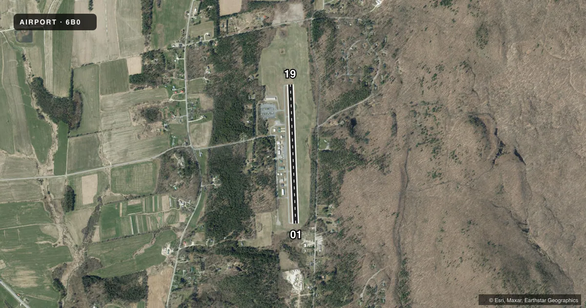
Airport sketch
Runways drawn to scale from FAA survey coordinates, rendered over satellite imagery. Not for navigation.
Approaches & charts
Services on the field
Fuel grades, oxygen, maintenance, ramp storage and lighting — as declared to the FAA by the airport operator.
Fuel & services
- Fuel
- 100LL
- Oxygen (bottled)
- Not available
- Oxygen (bulk)
- Not available
- Airframe repair
- Major
- Power plant repair
- Major
- Other services
- AVNCS,PAJA
Ramp & ground
- Transient storage
- Tie-down
- Landing fee
- No fee published
- Customs
- Not available
- Wind indicator
- Yes
- Segmented circle
- Yes
Fuel & FBOs
Cheapest 100LL and Jet A on the field and nearby. Always confirm with the FBO before taxi.
Airport notes
Surface conditions, obstructions, local procedures, lighting outages and other notes published with each FAA cycle.
General notes
- HIGH HILLS EAST OF ARPT.
- RWY CONDS MAY NOT BE MNT OR RPRTD WHEN THE ARPT IS UNATNDD.
- ULTRA-LIGHT & AGRICULTURAL ACFT ACTVTY ON & INVOF ARPT.
- NO LN OF SIGHT BTN RWY ENDS.
- PAJA ON WKENDS.
- FOR CD CTC BURLINGTON APCH AT 802-657-4413, WHEN APCH CLSD CTC BOSTON ARTCC AT 603-879-6859.
Fuel notes
- 100LLFULL SVC ONLY M-F DAWN TO DUSK.
Approach & departure obstructions
- 0120 FT TREES, 99-199 FT, 124 FT R.
- 01OBSTN CLNC SLP 5:1 TO DTHR OVR 36 FT TREES, 215 FT.
Other notes
- EXISTED PRIOR TO 1959.
- SEGMENTED CIRCLE NON-STANDARD. ONLY TFC PAT INDICATORS.
- 810 FT AGL SINGL ENG, 1010 FT AGL MULT ENG.
- AVNCSAVIONICS RETROFITS & AVIONICS SVCS.
VFR map & nearby airports
VFR sectional. Tap any ICAO chip to open that airport.
Key facts · 6B0
Answer card- ICAO
- 6B0
- Name
- MIDDLEBURY STATE
- Location
- MIDDLEBURY, VERMONT
- Elevation
- 494.1 ft MSL
- Traffic pattern altitude
- 1,304.1 ft MSL (810 AGL)
- Control tower
- Non-towered (use CTAF)
- Total runways
- 1
- Longest runway
- 01/19 · 3,206 ft
- Published ILS approaches
- 0
- Published frequencies
- 2
- Magnetic variation
- 15°
- Current flight rules
- VFR
- Current wind
- 280° at 3 kt
- Favored runway now
- RWY 01
Middlebury State Airport (6B0) sits in Middlebury, Vermont. Field elevation is 494.1 ft MSL. The airport has one runway, 01/19, which is 3,206 ft long. There is no control tower. CTAF and UNICOM are both 122.8. No ILS approaches are published here.
Pattern altitude is 810 ft AGL, which is 1,304.1 ft MSL for single-engine aircraft. The published remarks also call out 1,010 ft AGL for multi-engine aircraft. If you are new to the field, note the high hills east of the airport. Runway 01 has a published obstacle clearance concern with trees near the departure path. There are also trees off the right side near runway 01. The segmented circle is non-standard and only has traffic pattern indicators, so brief yourself before arrival.
Middlebury State Airport, the on-field FBO, reports fuel grades but does not list them in the facts here. Call (802) 388-1800 for current fuel availability and services. Full service 100LL is available Monday through Friday from dawn to dusk. Ultralight and agricultural aircraft activity also occurs on and near the airport. For clearance delivery, contact Burlington Approach at 802-657-4413. When Burlington Approach is closed, contact Boston ARTCC at 603-879-6859. Runway conditions may not be maintained or reported when the airport is unattended.