METAR & TAF 4B6
4B6 does not publish a METAR.
Showing the nearest reporting station: KRUT (RUTLAND/SOUTHERN VERMONT RGNL) · 29.0 NM away. Conditions at 4B6 may differ.
METAR · KRUT
Observed 16:56Z
KRUT 271656Z AUTO 21006KT 10SM CLR 27/16 A2982 RMK AO2 SLP089 T02720161
- Wind
- 210° @ 6 kt
- Visibility
- 10 SM
- Temp / Dew
- 27°C / 16°C
- Altimeter
- 29.82 inHg
- Clouds
- CLR
- Density alt
- 1,903 ft
- Ceiling
- Unlimited
- Rules
- VFR
Airport info & contacts
Manager on record, flight service, ARTCC, attendance schedule and pattern altitude — published by the FAA and refreshed every 28 days.
Location
- From city
- 2 NM NE
- VFR sectional
- NEW YORK
- ARTCC
- ZBW · BOSTON
- NOTAM facility
- BTV (NOTAM-D)
Airport manager
- Name
- MARK A. WRIGHT
- Phone
- 518-585-6265
- Address
- 132 MONTCALM ST, TICONDEROGA NY 12883
Flight service · Hours
- FSS BTV
- BURLINGTON1-800-WX-BRIEF
- Attendance
- Unattended
Frequencies
Tap any row to copy the frequency to your clipboard.
Runways & pattern
Full pagePattern entry · RWY 20
RIGHT TRAFFICRunway end performance
| End | TORA | TODA | ASDA | LDA | VGSI | Approach lights | Obstruction |
|---|---|---|---|---|---|---|---|
| 02 | — | — | — | — | PAPI 2-box left(3°) | — | 10', fence, 200' from thr, 216' R of cntrln, slope 0 |
| 20 | — | — | — | — | PAPI 2-box left(3°) | — | 30', trees, 200' from thr, 116' R of cntrln, slope 0 |
Declared distances in feet. TORA = takeoff run available, TODA = takeoff distance, ASDA = accelerate-stop, LDA = landing distance.
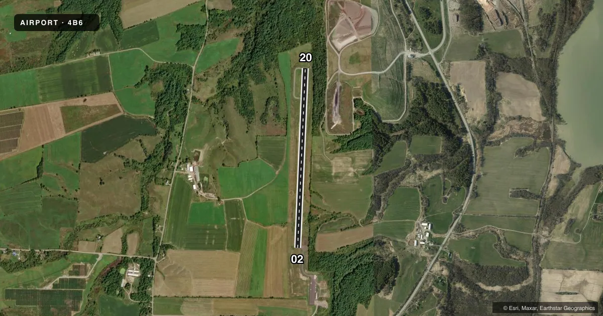
Airport sketch
Runways drawn to scale from FAA survey coordinates, rendered over satellite imagery. Not for navigation.
Approaches & charts
Services on the field
Fuel grades, oxygen, maintenance, ramp storage and lighting — as declared to the FAA by the airport operator.
Fuel & services
- Fuel
- 100LL
Ramp & ground
- Transient storage
- Tie-down
- Hangar
- Landing fee
- No fee published
- Lighting schedule
- SEE RMK
- Wind indicator
- Lighted
- Segmented circle
- Yes
Fuel & FBOs
Cheapest 100LL and Jet A on the field and nearby. Always confirm with the FBO before taxi.
Airport notes
Surface conditions, obstructions, local procedures, lighting outages and other notes published with each FAA cycle.
General notes
- ARPT FEES - HNGR, TIE DOWN; LDG FOR PART 135, JET/TURBINE.
- RWY 02; 50 FT TREES 1150 FT FM RWY END 50 FT LEFT.
- WINTER OPS DECEMBER - MARCH CALL FOR RWY CONDITIONS.
- WILDLIFE ON & INVOF ARPT.
- FOR CD CTC BOSTON ARTCC AT 603-879-6859.
Lighting notes
- ACTVT REIL RWY 02 & 20; PAPI RWY 02 & 20; MIRL RWY 02/20 - CTAF.
Fuel notes
- 100LL100 LL SELF SVC CREDIT CARD.
Runway surface & condition
- 02/20RWY 02; 2 THR LGTS OTS INDEFLY.
Approach & departure obstructions
- 0210 FT FENCE 0-200 FT FM RWY 216 FT LEFT.
- 2030 FT TREES, 0-200 FT FM RWY, 116 FT LEFT.
- 02CTLNG OBSTN EXCEEDS A 45 DEG SLP.
Other notes
- VFR USE ONLY.
VFR map & nearby airports
VFR sectional. Tap any ICAO chip to open that airport.
Key facts · 4B6
Answer card- ICAO
- 4B6
- Name
- TICONDEROGA MUNI
- Location
- TICONDEROGA, NEW YORK
- Elevation
- 273.6 ft MSL
- Traffic pattern altitude
- 1,273.6 ft MSL (1,000 AGL)
- Control tower
- Non-towered (use CTAF)
- Total runways
- 1
- Longest runway
- 02/20 · 4,041 ft
- Published ILS approaches
- 0
- Published frequencies
- 2
- Magnetic variation
- 15°
- Current flight rules
- VFR
- Current wind
- 210° at 6 kt
- Favored runway now
- RWY 20
Ticonderoga Muni Airport (4B6) sits in Ticonderoga, New York. Field elevation is 273.6 ft MSL. The airport has one runway, 02/20, which is 4,041 ft long and asphalt. There is no control tower. CTAF and UNICOM are both 122.8.
No ILS approaches are published here. Pattern altitude is not published, so use the standard 1,000 ft AGL for light piston operations unless the current FAA Chart Supplement says otherwise. The on-field FBO is Ticonderoga Municipal Airport. It carries AVGAS 100LL. Self-serve 100LL is available with credit card.
A few published remarks matter here. Runway 02 has threshold lights out of service indefinitely. Runway end identifier lights, PAPI and medium intensity runway lights are available on 02 and 20. The lights are controlled by CTAF. There are also obstructions near both runway ends. Runway 02 has trees off the departure end. Runway 20 has trees near the approach side. Wildlife is reported on and near the airport. Winter operations run from December through March. Call for runway conditions before you go. This is VFR use only. Plan with the current FAA Chart Supplement and be ready for local conditions.