METAR & TAF 83K
83K does not publish a METAR.
Showing the nearest reporting station: KGFL (FLOYD BENNETT MEML) · 5.3 NM away. Conditions at 83K may differ.
METAR · KGFL
Observed 14:53Z
KGFL 271453Z AUTO VRB06KT 10SM CLR 26/17 A2982 RMK AO2 SLP095 T02610167 57008
- Wind
- VAR @ 6 kt
- Visibility
- 10 SM
- Temp / Dew
- 26°C / 17°C
- Altimeter
- 29.82 inHg
- Clouds
- CLR
- Density alt
- 1,768 ft
- Ceiling
- Unlimited
- Rules
- VFR
Airport info & contacts
Manager on record, flight service, ARTCC, attendance schedule and pattern altitude — published by the FAA and refreshed every 28 days.
Location
- From city
- 2 NM W
- VFR sectional
- NEW YORK
- ARTCC
- ZBW · BOSTON
- NOTAM facility
- BTV (NOTAM-D)
Airport manager
- Name
- STEVIN OBRIEN
- Phone
- 518-232-7896
- Address
- 10915 STATE ROUTE 149, FORT ANN NY 12827
Flight service · Hours
- FSS BTV
- BURLINGTON1-800-WX-BRIEF
- Attendance
- UNATTNDD
Frequencies
Tap any row to copy the frequency to your clipboard.
Runways & pattern
Full pagePattern entry · RWY 04
RIGHT TRAFFICRunway end performance
| End | TORA | TODA | ASDA | LDA | VGSI | Approach lights | Obstruction |
|---|---|---|---|---|---|---|---|
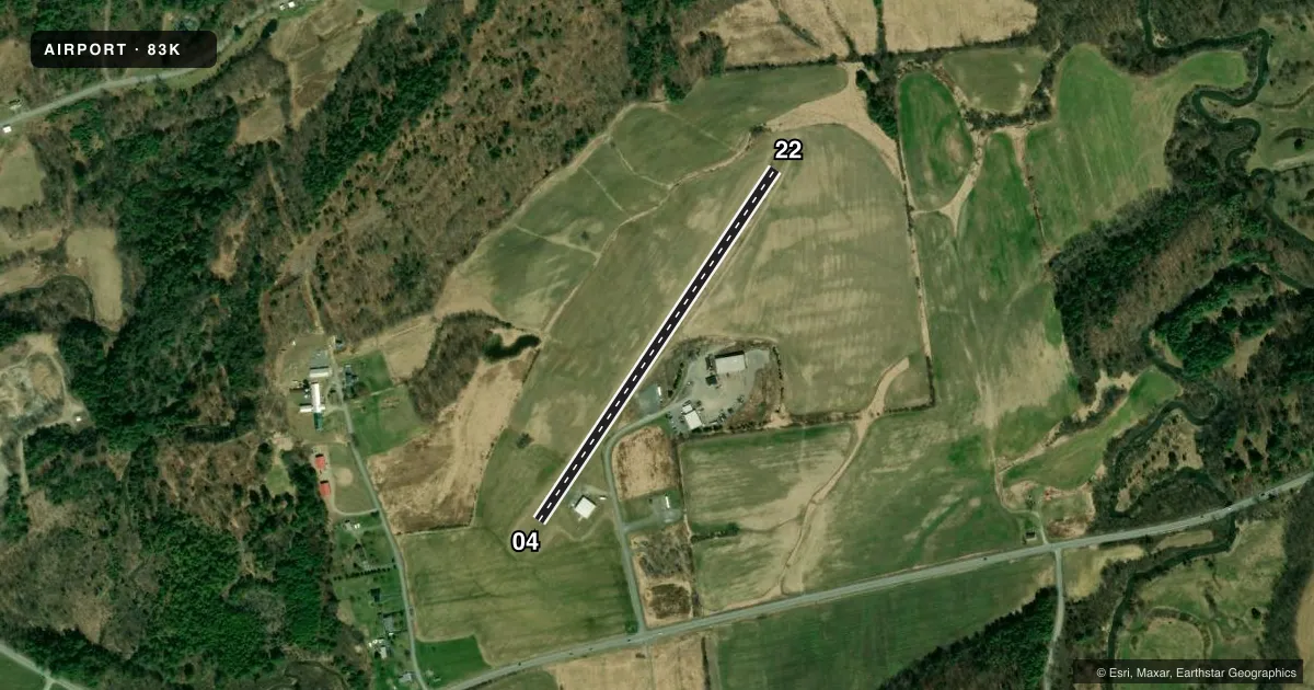
| 04 | — | — | — | — | — | — | 69', tree, 787' from thr, 97' R of cntrln, slope 11 |
| 22 | — | — | — | — | — | — | 73', tree, 716' from thr, 75' R of cntrln, slope 9 |
Declared distances in feet. TORA = takeoff run available, TODA = takeoff distance, ASDA = accelerate-stop, LDA = landing distance.
Airport sketch
Runways drawn to scale from FAA survey coordinates, rendered over satellite imagery. Not for navigation.
Approaches & charts
Services on the field
Fuel grades, oxygen, maintenance, ramp storage and lighting — as declared to the FAA by the airport operator.
Fuel & services
- Fuel
- 100LL
- Oxygen (bottled)
- Not available
- Oxygen (bulk)
- Not available
- Airframe repair
- Not available
- Power plant repair
- Not available
- Other services
- INSTR,PAJA
Ramp & ground
- Transient storage
- Tie-down
- Hangar
- Wind indicator
- Yes
- Segmented circle
- No
Fuel & FBOs
Cheapest 100LL and Jet A on the field and nearby. Always confirm with the FBO before taxi.
Airport notes
Surface conditions, obstructions, local procedures, lighting outages and other notes published with each FAA cycle.
General notes
- NO FLYING W OF RWY OVER HOUSES.
- FOR CD CTC ALBANY APCH AT 518-862-2299.
Other notes
- PRVDD VFR/PVT USE.
- 04/22UPSLOPE AT THRESHOLD RWY 22.
VFR map & nearby airports
VFR sectional. Tap any ICAO chip to open that airport.
Key facts · 83K
Answer card- ICAO
- 83K
- Name
- HARRIS
- Location
- FORT ANN, NEW YORK
- Elevation
- 261 ft MSL
- Traffic pattern altitude
- 1,261 ft MSL (1,000 AGL)
- Control tower
- Non-towered (use CTAF)
- Total runways
- 1
- Longest runway
- 04/22 · 2,200 ft
- Published ILS approaches
- 0
- Published frequencies
- 1
- Magnetic variation
- –
- Current flight rules
- VFR
- Current wind
- 000° at 6 kt
- Favored runway now
- RWY 04
Harris Airport (83K) is in Fort Ann, New York. The field elevation is 261 ft MSL. It has one runway, 04/22, which is 2,200 ft of turf. This is a non-towered field. CTAF is 122.9.
No ILS approaches are published here. Pattern altitude is not published in the facts, so use the current Chart Supplement before you fly. The airport is listed for VFR and private use. That matters if you are planning a first visit.
There are a couple of operational points to know before arrival. Do not fly west of the runway over houses. Runway 22 also has an upslope at the threshold, so plan your landing and rollout with that in mind. For clearance delivery, Albany Approach can be reached at 518-862-2299.
No on-field FBOs are listed in the facts. Verify fuel and services with the airport operator or call the field directly before departure. If you are coming in from higher terrain or on a warm day, keep the turf surface and short runway length in mind during performance planning.