METAR & TAF VT8
VT8 does not publish a METAR.
Showing the nearest reporting station: KBTV (PATRICK LEAHY BURLINGTON INTL) · 7.4 NM away. Conditions at VT8 may differ.
METAR · KBTV
Observed 16:54Z
KBTV 271654Z 26004KT 10SM SCT065 29/16 A2978 RMK AO2 SLP082 T02890156
- Wind
- 260° @ 4 kt
- Visibility
- 10 SM
- Temp / Dew
- 29°C / 16°C
- Altimeter
- 29.78 inHg
- Clouds
- SCT
- Density alt
- 2,257 ft
- Ceiling
- Unlimited
- Rules
- VFR
Airport info & contacts
Manager on record, flight service, ARTCC, attendance schedule and pattern altitude — published by the FAA and refreshed every 28 days.
Location
- From city
- 2 NM S
- VFR sectional
- MONTREAL
- ARTCC
- ZBW · BOSTON
- NOTAM facility
- BTV (NOTAM-D)
Airport manager
- Name
- BARBARA MAGEE
- Phone
- 802-985-2100
- Address
- 144 AIRPARK RD., SHELBURNE VT 05482
Flight service · Hours
- FSS BTV
- BURLINGTON1-800-WX-BRIEF
- Attendance
- Unattended
Frequencies
Tap any row to copy the frequency to your clipboard.
Runways & pattern
Full pagePattern entry · RWY 19
LEFT TRAFFICRunway end performance
| End | TORA | TODA | ASDA | LDA | VGSI | Approach lights | Obstruction |
|---|---|---|---|---|---|---|---|
| 01 | — | — | — | — | — | — | 70', trees, 0' from thr, 125' R of cntrln, slope 0 |
| 19 | — | — | — | — | — | — | 70', trees, 0' from thr, 125' R of cntrln, slope 0 |
Declared distances in feet. TORA = takeoff run available, TODA = takeoff distance, ASDA = accelerate-stop, LDA = landing distance.
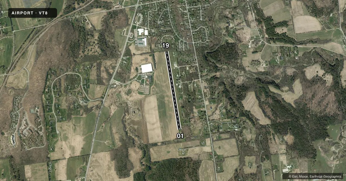
Airport sketch
Runways drawn to scale from FAA survey coordinates, rendered over satellite imagery. Not for navigation.
Approaches & charts
Services on the field
Fuel grades, oxygen, maintenance, ramp storage and lighting — as declared to the FAA by the airport operator.
Fuel & services
- Fuel
- Not available
- Airframe repair
- Not available
- Power plant repair
- Not available
Ramp & ground
- Transient storage
- Tie-down
- Hangar
- Landing fee
- No fee published
- Wind indicator
- Yes
- Segmented circle
- No
Fuel & FBOs
Cheapest 100LL and Jet A on the field and nearby. Always confirm with the FBO before taxi.
Airport notes
Surface conditions, obstructions, local procedures, lighting outages and other notes published with each FAA cycle.
General notes
- NO LN OF SIGHT BTN RWY ENDS.
- FOR CD CTC BURLINGTON APCH AT 802-657-4413, WHEN APCH CLSD CTC BOSTON ARTCC AT 603-879-6859.
- RWY SFC ROUGH FST 200 FT EACH END.
- 70 FT POLE MID-FLD, 200 FT E OF RWY CNTRLN.
Approach & departure obstructions
- 01CTLG OBSTN EXCEEDS A 45 DEG SLP.
Other notes
- PRVDD ALL OPNS BE RESTRICTED TO SMALL ACFT ONLY; VFR OPNS; AND ALL USERS ARE NOTIFIED AND COMPLY WITH THESE CONDITIONS.
VFR map & nearby airports
VFR sectional. Tap any ICAO chip to open that airport.
Key facts · VT8
Answer card- ICAO
- VT8
- Name
- SHELBURNE
- Location
- SHELBURNE, VERMONT
- Elevation
- 325 ft MSL
- Traffic pattern altitude
- 1,325 ft MSL (1,000 AGL)
- Control tower
- Non-towered (use CTAF)
- Total runways
- 1
- Longest runway
- 01/19 · 3,077 ft
- Published ILS approaches
- 0
- Published frequencies
- 2
- Magnetic variation
- 15°
- Current flight rules
- VFR
- Current wind
- 260° at 4 kt
- Favored runway now
- RWY 19
Shelburne Airport (VT8) is in Shelburne, Vermont. The field elevation is 325 ft MSL. It has one runway. Runway 01/19 is 3,077 ft of turf, which is the longest runway on the field. There is no control tower. CTAF and UNICOM are both 122.8. No ILS approaches are published here.
The pattern altitude is not published. Use 1,000 ft AGL for light piston operations unless the current FAA Chart Supplement says otherwise. That puts the pattern at about 1,325 ft MSL based on the field elevation. The airport remarks say operations are restricted to small aircraft only and VFR only. That matters here. This is not a place to plan an IFR arrival.
The published remarks also call out rough runway surface in the first 200 feet at each end. There is no line of sight between runway ends. A 70 foot pole sits mid-field, 200 feet east of the runway centerline. There is also a cataloged obstruction that exceeds a 45 degree slope at the runway 01 end. For clearance delivery, contact Burlington Approach at 802-657-4413. When approach is closed, contact Boston ARTCC at 603-879-6859. If you are planning a first visit, review the current FAA Chart Supplement and be ready for a short turf field with limited visibility between ends.