METAR & TAF KMVL
Current METAR
Observed 14:54Z
KMVL 271454Z AUTO 00000KT 10SM CLR 25/13 A2985 RMK AO2 SLP105 T02500128 58008
- Wind
- 000° @ 0 kt
- Visibility
- 10 SM
- Temp / Dew
- 25°C / 13°C
- Altimeter
- 29.85 inHg
- Clouds
- CLR
- Density alt
- 2,196 ft
- Ceiling
- Unlimited
- Rules
- VFR
Airport info & contacts
Manager on record, flight service, ARTCC, attendance schedule and pattern altitude — published by the FAA and refreshed every 28 days.
Location
- From city
- 2 NM SW
- VFR sectional
- MONTREAL
- ARTCC
- ZBW · BOSTON
- NOTAM facility
- MVL (NOTAM-D)
Airport manager
- Name
- EDDIE MIDDLETON
- Phone
- 802-279-9746
- Address
- 219 N MAIN ST, BARRE VT 05641
Flight service · Hours
- FSS BTV
- BURLINGTON1-800-WX-BRIEF
- Attendance
- Unattended
Frequencies
Tap any row to copy the frequency to your clipboard.
Runways & pattern
Full pagePattern entry · RWY 01
LEFT TRAFFICRunway end performance
| End | TORA | TODA | ASDA | LDA | VGSI | Approach lights | Obstruction |
|---|---|---|---|---|---|---|---|
| 01 | — | — | — | — | — | — | 15', trees, 201' from thr, 250' R of cntrln, slope 0 |
| 19 | — | — | — | — | PAPI 2-box left(3.5°) | — | — |
Declared distances in feet. TORA = takeoff run available, TODA = takeoff distance, ASDA = accelerate-stop, LDA = landing distance.
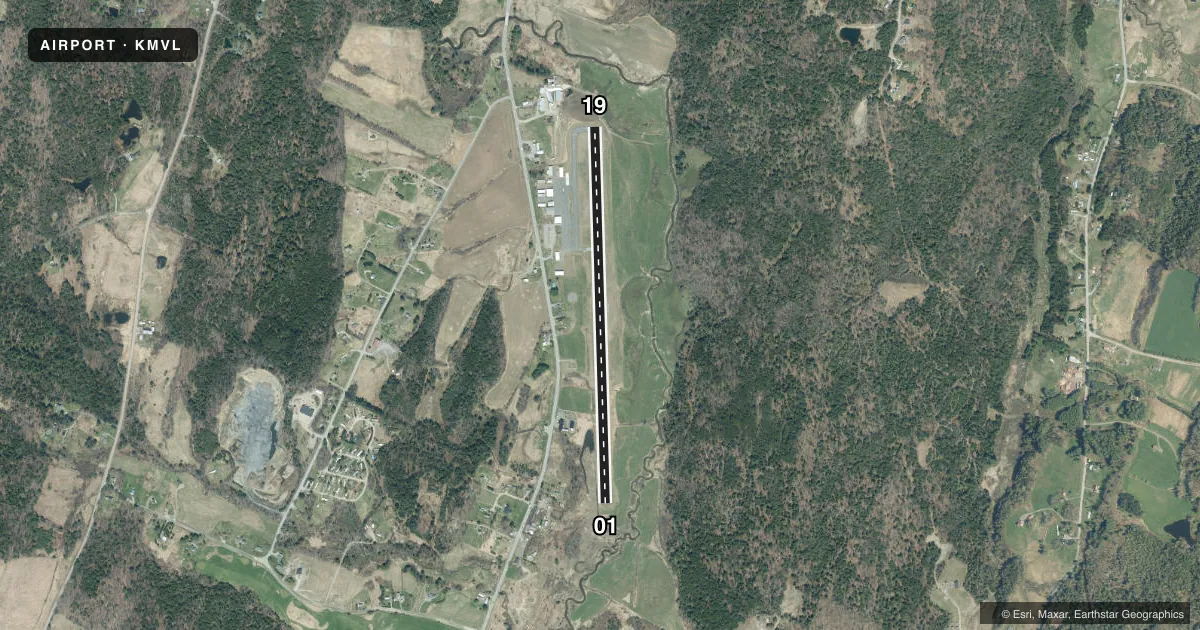
Airport sketch
Runways drawn to scale from FAA survey coordinates, rendered over satellite imagery. Not for navigation.
Approaches & charts
Services on the field
Fuel grades, oxygen, maintenance, ramp storage and lighting — as declared to the FAA by the airport operator.
Fuel & services
- Fuel
- 100LLA
- Oxygen (bottled)
- Not available
- Oxygen (bulk)
- Not available
- Airframe repair
- Not available
- Power plant repair
- Not available
Ramp & ground
- Transient storage
- Tie-down
- Landing fee
- No fee published
- Customs
- Not available
- Lighting schedule
- SEE RMK
- Beacon schedule
- SS-SR
- Beacon
- White / Green (civil land)(WG)
- Wind indicator
- Lighted
- Segmented circle
- Yes
Fuel & FBOs
Cheapest 100LL and Jet A on the field and nearby. Always confirm with the FBO before taxi.
Airport notes
Surface conditions, obstructions, local procedures, lighting outages and other notes published with each FAA cycle.
General notes
- RWY CONDS NOT MNT WHEN UNATNDD.
- 3 FT SWALES MID 1/3 OF RWY ON E & W SIDES OUTSIDE OF RWY SAFETY AREA.
- COLD TEMPERATURE AIRPORT. ALTITUDE CORRECTION REQUIRED AT OR BELOW -19C.
- FOR CD CTC BOSTON ARTCC AT 603-879-6859.
Lighting notes
- ACTVT REIL RWYS 01 & 19; PAPI RWY 19; HIRL RWY 01/19 - CTAF.
Fuel notes
- 100LLSELF SVC ONLY.
- ASELF SVC ONLY.
Approach & departure obstructions
- 01CLOSE-IN OBSTN 15 FT TREES, 99-199 FT, 225 FT R.
- 19CLOSE-IN OBSTN 5 FT FENCE, 70 FT, 250 FT L/R; 4 FT CONC WALL, 33 FT, 129 FT R.
- 01OBSTN CLNC SLP 0:1 AT DTHR OVR 30 FT TREES, 218 FT L.
Other notes
- FILED FOR RECORD PURPOSES ONLY.
VFR map & nearby airports
VFR sectional. Tap any ICAO chip to open that airport.
Key facts · KMVL
Answer card- ICAO
- KMVL
- Name
- MORRISVILLE-STOWE STATE
- Location
- MORRISVILLE, VERMONT
- Elevation
- 732.9 ft MSL
- Traffic pattern altitude
- 1,732.9 ft MSL (1,000 AGL)
- Control tower
- Non-towered (use CTAF)
- Total runways
- 1
- Longest runway
- 01/19 · 4,200 ft
- Published ILS approaches
- 0
- Published frequencies
- 2
- Magnetic variation
- 16°
- Current flight rules
- VFR
- Current wind
- 000° at 0 kt
- Favored runway now
- –
Morrisville-Stowe State Airport sits in Morrisville, Vermont. Field elevation is 732.9 ft MSL. The airport has one runway, 01/19, which is 4,200 ft long. There is no control tower. CTAF and UNICOM are both 122.8.
No ILS approaches are published here. Pattern altitude is not published, so use the standard 1,000 ft AGL for light piston traffic unless the current Chart Supplement says otherwise. The field has close-in obstacles near both runway ends. Runway 19 has a PAPI. Runway end identifier lights and high intensity runway lights are on 01 and 19. The lights are controlled by CTAF.
There are no on-field FBOs listed in the facts. Fuel is self-serve only for fuel type A. Self-serve 100LL is also available. Runway conditions are not maintained when unattended. That matters here if you are planning a late arrival or an early departure. The airport is also listed as a cold temperature airport. Altitude correction is required at or below minus 19 degrees Celsius. For clearance delivery, contact Boston ARTCC. If you want the latest operational details, check the current FAA Chart Supplement or call the airport operator before you go.