METAR & TAF 5B1
5B1 does not publish a METAR.
Showing the nearest reporting station: KCDA (CALEDONIA COUNTY) · 15.6 NM away. Conditions at 5B1 may differ.
METAR · KCDA
Observed 12:35Z
KCDA 241235Z AUTO 00000KT 10SM CLR 16/13 A2993 RMK AO2 T01620129
- Wind
- 000° @ 0 kt
- Visibility
- 10 SM
- Temp / Dew
- 16°C / 13°C
- Altimeter
- 29.93 inHg
- Clouds
- CLR
- Density alt
- 1,588 ft
- Ceiling
- Unlimited
- Rules
- VFR
Airport info & contacts
Manager on record, flight service, ARTCC, attendance schedule and pattern altitude — published by the FAA and refreshed every 28 days.
Location
- From city
- 3 NM SE
- VFR sectional
- MONTREAL
- ARTCC
- ZBW · BOSTON
- NOTAM facility
- BTV (NOTAM-D)
Airport manager
- Name
- CHRIS BEITZEL
- Phone
- 802-272-7725
- Address
- 219 N MAIN ST, BARRE VT 05641
Flight service · Hours
- FSS BTV
- BURLINGTON1-800-WX-BRIEF
- Attendance
- Unattended
Frequencies
Tap any row to copy the frequency to your clipboard.
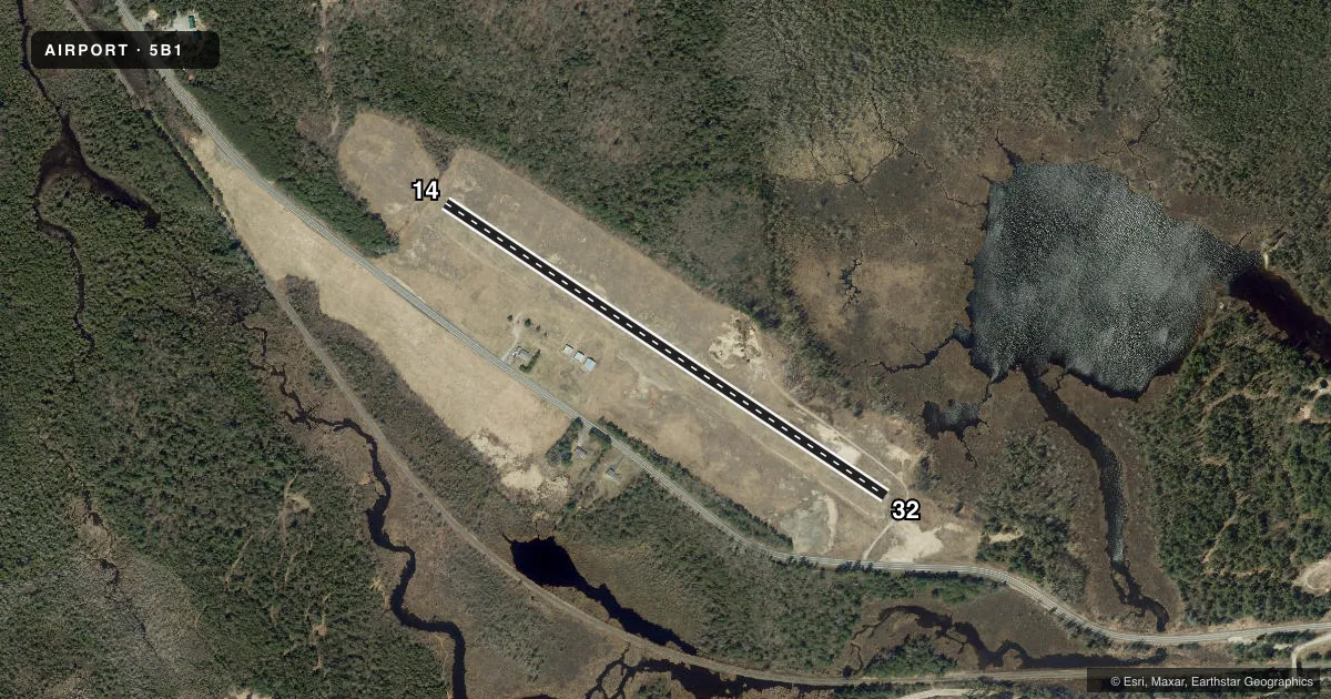
Runways & pattern
Full pagePattern entry · RWY 14
LEFT TRAFFICRunway end performance
| End | TORA | TODA | ASDA | LDA | VGSI | Approach lights | Obstruction |
|---|---|---|---|---|---|---|---|
| 14 | — | — | — | — | — | — | 75', trees, 355' from thr, 145' R of cntrln, slope 4 |
| 32 | — | — | — | — | — | — | 80', trees, 600' from thr, 55' R of cntrln, slope 7 |
Declared distances in feet. TORA = takeoff run available, TODA = takeoff distance, ASDA = accelerate-stop, LDA = landing distance.
Airport sketch
Runways drawn to scale from FAA survey coordinates, rendered over satellite imagery. Not for navigation.
Approaches & charts
Services on the field
Fuel grades, oxygen, maintenance, ramp storage and lighting — as declared to the FAA by the airport operator.
Fuel & services
- Fuel
- Not available
- Oxygen (bottled)
- Not available
- Oxygen (bulk)
- Not available
- Airframe repair
- Not available
- Power plant repair
- Not available
Ramp & ground
- Transient storage
- Tie-down
- Hangar
- Landing fee
- No fee published
- Customs
- Not available
- Wind indicator
- Yes
- Segmented circle
- Yes
Fuel & FBOs
Cheapest 100LL and Jet A on the field and nearby. Always confirm with the FBO before taxi.
Airport notes
Surface conditions, obstructions, local procedures, lighting outages and other notes published with each FAA cycle.
General notes
- SKI OPS IN WINTER.
- FOR CD CTC BOSTON ARTCC AT 603-879-6859.
Approach & departure obstructions
- 14THR MKD WITH YELLOW CONES.
- 32THR MKD WITH YELLOW CONES.
Other notes
- FREQ 122.900.
VFR map & nearby airports
VFR sectional. Tap any ICAO chip to open that airport.
Key facts · 5B1
Answer card- ICAO
- 5B1
- Name
- JOHN H BOYLAN STATE (ISLAND POND)
- Location
- ISLAND POND, VERMONT
- Elevation
- 1,194 ft MSL
- Traffic pattern altitude
- 2,194 ft MSL (1,000 AGL)
- Control tower
- Non-towered (use CTAF)
- Total runways
- 1
- Longest runway
- 14/32 · 2,650 ft
- Published ILS approaches
- 0
- Published frequencies
- 1
- Magnetic variation
- 17°
- Current flight rules
- VFR
- Current wind
- 000° at 0 kt
- Favored runway now
- –
John H Boylan State Airport (5B1) sits in Island Pond, Vermont. The field elevation is 1,194 ft MSL. It has one runway. Runway 14/32 is 2,650 ft of turf, which makes the airport a short-field, light-aircraft stop rather than a place to plan on fixed-wing margin for error. The airport is non-towered. CTAF and UNICOM are both 122.9. No ILS approaches are published here.
Pattern altitude is not published. Use the standard 1,000 ft AGL for light piston traffic unless the current Chart Supplement says otherwise. The runway thresholds on 14 and 32 are marked with yellow cones. That is worth a close look on arrival, especially if you are used to paved strips.
There are no on-field FBOs listed. Plan on verifying services with the airport operator or the FBO directly by phone before you go. For IFR clearance delivery, Boston ARTCC is the published contact. Winter ski operations also occur here, so expect seasonal activity on or near the field. With a turf runway, a mountain-state elevation and no published ILS, this is a place to brief your arrival carefully and check the current Chart Supplement before departure.