METAR & TAF KEFK
Current METAR
Observed 06:35Z
KEFK 270635Z AUTO 21003KT 10SM CLR 16/14 A2986 RMK AO2 T01590140
- Wind
- 210° @ 3 kt
- Visibility
- 10 SM
- Temp / Dew
- 16°C / 14°C
- Altimeter
- 29.86 inHg
- Clouds
- CLR
- Density alt
- 1,352 ft
- Ceiling
- Unlimited
- Rules
- VFR
Airport info & contacts
Manager on record, flight service, ARTCC, attendance schedule and pattern altitude — published by the FAA and refreshed every 28 days.
Location
- From city
- 3 NM SW
- VFR sectional
- MONTREAL
- ARTCC
- ZBW · BOSTON
- NOTAM facility
- BTV (NOTAM-D)
Airport manager
- Name
- CHRIS BEITZEL
- Phone
- 802-272-7725
- Address
- 219 N MAIN ST, BARRE VT 05641
Flight service · Hours
- FSS BTV
- BURLINGTON1-800-WX-BRIEF
- Attendance
- 0900-1700
Frequencies
Tap any row to copy the frequency to your clipboard.
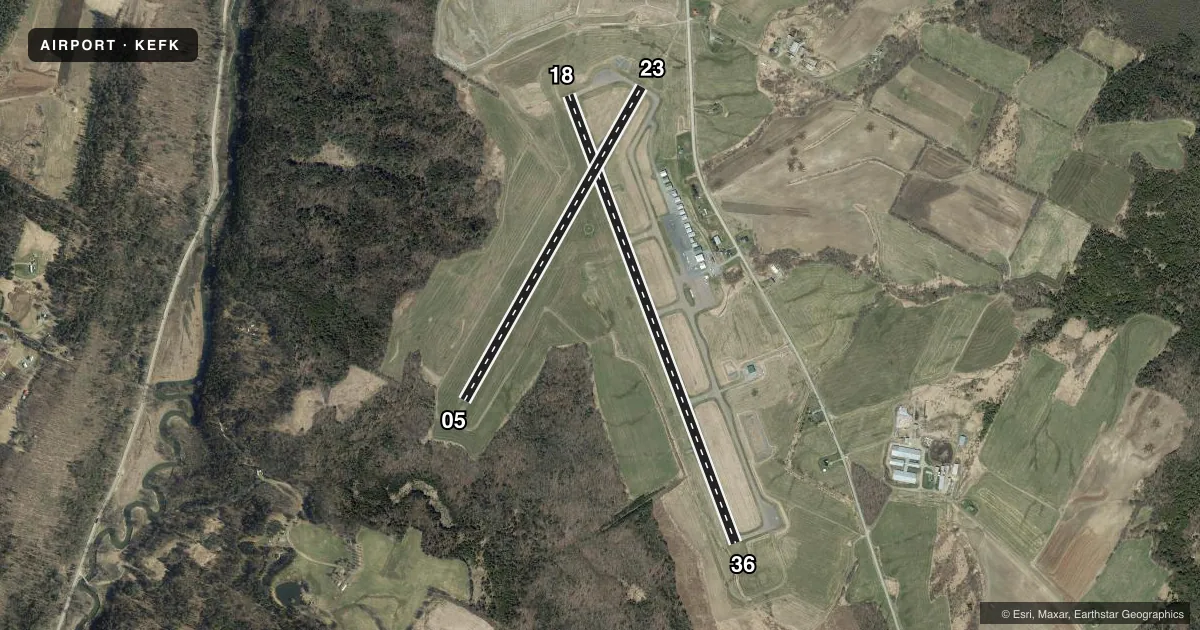
Runways & pattern
Full pagePattern entry · RWY 23
LEFT TRAFFIC| Runway | Heading (°M) | Length | Surface | Traffic |
|---|---|---|---|---|
| 18/36 | 143° / 323° | 5,301 ft | ASPH | Standard L |
| 05/23Favored | 13° / 193° | 3,996 ft | ASPH | Standard L |
Runway end performance
| End | TORA | TODA | ASDA | LDA | VGSI | Approach lights | Obstruction |
|---|---|---|---|---|---|---|---|
| 18 | — | — | — | — | PAPI 4-box left(3°) | — | — |
| 36 | — | — | — | — | PAPI 4-box left(3°) | — | 68', gnd, 2188' from thr, 671' R of cntrln, slope 29 |
| 05 | — | — | — | — | — | — | 55', trees, 475' from thr, 60' R of cntrln, slope 6 |
| 23 | — | — | — | — | — | — | 42', pole, 850' from thr, 190' R of cntrln, slope 15 |
Declared distances in feet. TORA = takeoff run available, TODA = takeoff distance, ASDA = accelerate-stop, LDA = landing distance.
Airport sketch
Runways drawn to scale from FAA survey coordinates, rendered over satellite imagery. Not for navigation.
Approaches & charts
Services on the field
Fuel grades, oxygen, maintenance, ramp storage and lighting — as declared to the FAA by the airport operator.
Fuel & services
- Fuel
- 100LLA+
- Oxygen (bottled)
- Not available
- Oxygen (bulk)
- Not available
- Airframe repair
- Major
- Power plant repair
- Major
- Other services
- INSTR,RNTL
Ramp & ground
- Transient storage
- Tie-down
- Hangar
- Landing fee
- No fee published
- Customs
- Not available
- Lighting schedule
- SEE RMK
- Beacon schedule
- SS-SR
- Beacon
- White / Green (civil land)(WG)
- Wind indicator
- Lighted
- Segmented circle
- Yes
Fuel & FBOs
Cheapest 100LL and Jet A on the field and nearby. Always confirm with the FBO before taxi.
Airport notes
Surface conditions, obstructions, local procedures, lighting outages and other notes published with each FAA cycle.
General notes
- GULLS ON & INVOF ARPT.
- RWY CONDS NOT MNT WHEN UNATNDD.
- COLD TEMPERATURE AIRPORT. ALTITUDE CORRECTION REQUIRED AT OR BELOW -32C.
- FOR CD CTC BOSTON ARTCC AT 603-879-6859.
Lighting notes
- ACTVT PAPI RWY 18 & 36; MIRL RWY 18/36 - CTAF.
Fuel notes
- 100LL24 HR SELF SVC. MOBILE FUEL VEHICLE WHEN ATNDD.
- A+24 HR SELF SVC. MOBILE FUEL VEHICLE WHEN ATNDD.
Approach & departure obstructions
- 05EXTSV CRACKING, SHOULDERS FAILED.
Other notes
- ESTAB PRIOR 1959.
VFR map & nearby airports
VFR sectional. Tap any ICAO chip to open that airport.
Key facts · KEFK
Answer card- ICAO
- KEFK
- Name
- NORTHEAST KINGDOM INTL
- Location
- NEWPORT, VERMONT
- Elevation
- 933.9 ft MSL
- Traffic pattern altitude
- 1,933.9 ft MSL (1,000 AGL)
- Control tower
- Non-towered (use CTAF)
- Total runways
- 2
- Longest runway
- 18/36 · 5,301 ft
- Published ILS approaches
- 0
- Published frequencies
- 2
- Magnetic variation
- 17°
- Current flight rules
- VFR
- Current wind
- 210° at 3 kt
- Favored runway now
- RWY 23
Northeast Kingdom Intl (KEFK) is in Newport, Vermont. Field elevation is 933.9 ft MSL. The airport has two asphalt runways. The longest is runway 18/36 at 5,301 ft. There is no control tower. CTAF and UNICOM are both 122.8. No ILS approaches are published here.
Pattern altitude is not published. Use 1,000 ft AGL for light piston traffic unless the current Chart Supplement says otherwise. That puts the standard pattern at about 1,934 ft MSL based on the field elevation. Lakeview Aviation is on the field. It carries 100LL and Jet A. It also offers 24-hour self-serve fuel. A mobile fuel vehicle is available when attended.
This is a cold temperature airport. Altitude correction is required at or below minus 32 degrees Celsius. Runway conditions are not maintained when unattended. Runway 05 has extensive cracking and the shoulders have failed. Gulls are reported on and near the airport. PAPI lighting is available for runways 18 and 36. Medium intensity runway lights for 18 and 36 are activated on CTAF. For clearance delivery, contact Boston ARTCC. If you are planning a night or winter arrival, check the current Chart Supplement and brief the runway condition and lighting setup before you go.