METAR & TAF KFSO
Current METAR
Observed 15:35Z
KFSO 011535Z AUTO 21005KT 10SM CLR 29/22 A2991 RMK AO2 T02890217
- Wind
- 210° @ 5 kt
- Visibility
- 10 SM
- Temp / Dew
- 29°C / 22°C
- Altimeter
- 29.91 inHg
- Clouds
- CLR
- Density alt
- 1,975 ft
- Ceiling
- Unlimited
- Rules
- VFR
Airport info & contacts
Manager on record, flight service, ARTCC, attendance schedule and pattern altitude — published by the FAA and refreshed every 28 days.
Location
- From city
- 3 NM W
- VFR sectional
- MONTREAL
- ARTCC
- ZBW · BOSTON
- NOTAM facility
- BTV (NOTAM-D)
Airport manager
- Name
- CHRIS BEITZEL
- Phone
- 802-272-7725
- Address
- 219 N MAIN ST, BARRE VT 05641
Flight service · Hours
- FSS BTV
- BURLINGTON1-800-WX-BRIEF
- Attendance
- MON-FRI · 0830-1700
Frequencies
Tap any row to copy the frequency to your clipboard.
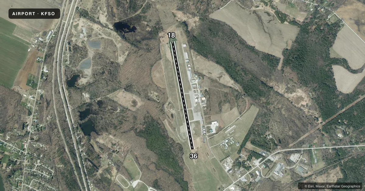
Runways & pattern
Full pagePattern entry · RWY 18
LEFT TRAFFICRunway end performance
| End | TORA | TODA | ASDA | LDA | VGSI | Approach lights | Obstruction |
|---|---|---|---|---|---|---|---|
| 36 | — | — | — | — | PAPI 2-box left(3°) | — | — |
Declared distances in feet. TORA = takeoff run available, TODA = takeoff distance, ASDA = accelerate-stop, LDA = landing distance.
Airport sketch
Runways drawn to scale from FAA survey coordinates, rendered over satellite imagery. Not for navigation.
Approaches & charts
Services on the field
Fuel grades, oxygen, maintenance, ramp storage and lighting — as declared to the FAA by the airport operator.
Fuel & services
- Fuel
- 100LLA1+
- Oxygen (bottled)
- Not available
- Oxygen (bulk)
- Not available
- Airframe repair
- Major
- Power plant repair
- Major
- Other services
- AVNCS,INSTR,PAJA,RNTL,SALES
Ramp & ground
- Transient storage
- Tie-down
- Hangar
- Landing fee
- No fee published
- Customs
- Not available
- Lighting schedule
- SEE RMK
- Beacon schedule
- SS-SR
- Beacon
- White / Green (civil land)(WG)
- Wind indicator
- Lighted
- Segmented circle
- Yes
Fuel & FBOs
Cheapest 100LL and Jet A on the field and nearby. Always confirm with the FBO before taxi.
Airport notes
Surface conditions, obstructions, local procedures, lighting outages and other notes published with each FAA cycle.
General notes
- RWY CONDS NOT MNT WHEN UNATNDD.
- BIRDS INVOF ARPT.
- FOR CD CTC BURLINGTON APCH AT 802-657-4413, WHEN APCH CLSD CTC BOSTON ARTCC AT 603-879-6859.
Lighting notes
- DUSK-DAWN. ACTVT REIL RWY 18 & 36; MIRL RWY 18/36 - CTAF. PAPI RWY 36 OPR CONSLY.
Fuel notes
- 100LLSELF SVC FUEL AVBL 24 HRS.
Runway surface & condition
- 18/36PCR VALUE: 200/F/C/X/T
VFR map & nearby airports
VFR sectional. Tap any ICAO chip to open that airport.
Key facts · KFSO
Answer card- ICAO
- KFSO
- Name
- FRANKLIN COUNTY STATE
- Location
- HIGHGATE, VERMONT
- Elevation
- 227.9 ft MSL
- Traffic pattern altitude
- 1,227.9 ft MSL (1,000 AGL)
- Control tower
- Non-towered (use CTAF)
- Total runways
- 1
- Longest runway
- 18/36 · 4,001 ft
- Published ILS approaches
- 0
- Published frequencies
- 5
- Magnetic variation
- 14°
- Current flight rules
- VFR
- Current wind
- 210° at 5 kt
- Favored runway now
- RWY 18
Franklin County State Airport sits in Highgate, Vermont. The field elevation is 227.9 ft MSL. It has one runway, 18/36, which is 4,001 ft long and paved with asphalt. There is no control tower. Traffic pattern altitude is not published, so use the standard 1,000 ft AGL for light piston operations unless current local guidance says otherwise.
No ILS approaches are published here. The airport is served by Burlington Approach for clearance delivery and approach control when that service is open. If approach is closed, Boston ARTCC handles clearance delivery. Border Air is on the field. It carries 100LL and Jet A. Self-serve 100LL is available 24 hours.
A few operational details matter here. Runway end identifier lights for 18 and 36 come on from dusk to dawn. Medium intensity runway lights are controlled by CTAF. The PAPI for runway 36 operates continuously. Runway conditions are not maintained when the airport is unattended. Birds are reported in the vicinity, so keep a sharp scan on departure and arrival. The pavement classification rating is 200/F/C/X/T. For a first visit, plan for an uncontrolled field with published lighting and local traffic on CTAF 122.8 or UNICOM 122.8.