METAR & TAF KHIE
Current METAR
Observed 03:52Z
KHIE 270352Z AUTO 00000KT 10SM CLR 13/12 A2988 RMK AO2 SLP117 T01330117
- Wind
- 000° @ 0 kt
- Visibility
- 10 SM
- Temp / Dew
- 13°C / 12°C
- Altimeter
- 29.88 inHg
- Clouds
- CLR
- Density alt
- 1,139 ft
- Ceiling
- Unlimited
- Rules
- VFR
Airport info & contacts
Manager on record, flight service, ARTCC, attendance schedule and pattern altitude — published by the FAA and refreshed every 28 days.
Location
- From city
- 3 NM E
- VFR sectional
- MONTREAL
- Pattern altitude
- 1,000 ft AGL · 2,072 ft MSL
- ARTCC
- ZBW · BOSTON
- NOTAM facility
- HIE (NOTAM-D)
Airport manager
- Name
- JAY ENNIS
- Phone
- 603-837-9532
- Address
- 56 LITTLETON RD, WHITEFIELD NH 03598
Flight service · Hours
- FSS BGR
- BANGOR1-800-WX-BRIEF
- Attendance
- IREG
Frequencies
Tap any row to copy the frequency to your clipboard.
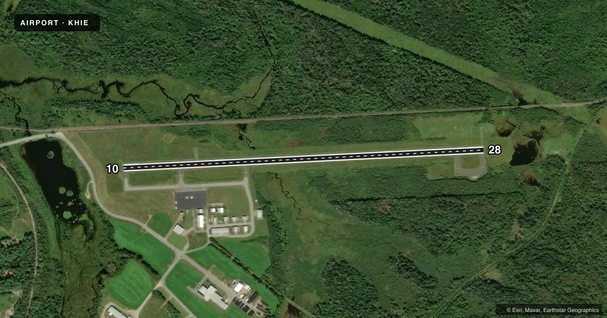
Runways & pattern
Full pagePattern entry · RWY 10
LEFT TRAFFICRunway end performance
| End | TORA | TODA | ASDA | LDA | VGSI | Approach lights | Obstruction |
|---|---|---|---|---|---|---|---|
| 10 | — | — | — | — | PAPI 4-box left(3.5°) | — | — |
| 28 | — | — | — | — | — | — | 62', trees, 791' from thr, 257' R of cntrln, slope 9 |
Declared distances in feet. TORA = takeoff run available, TODA = takeoff distance, ASDA = accelerate-stop, LDA = landing distance.
Airport sketch
Runways drawn to scale from FAA survey coordinates, rendered over satellite imagery. Not for navigation.
Approaches & charts
Services on the field
Fuel grades, oxygen, maintenance, ramp storage and lighting — as declared to the FAA by the airport operator.
Fuel & services
- Fuel
- 100LL
- Airframe repair
- Major
- Power plant repair
- Major
Ramp & ground
- Transient storage
- Tie-down
- Landing fee
- Yes
- Customs
- Not available
- Lighting schedule
- SEE RMK
- Beacon schedule
- SS-SR
- Beacon
- White / Green (civil land)(WG)
- Wind indicator
- Lighted
- Segmented circle
- Yes
Fuel & FBOs
Cheapest 100LL and Jet A on the field and nearby. Always confirm with the FBO before taxi.
Airport notes
Surface conditions, obstructions, local procedures, lighting outages and other notes published with each FAA cycle.
General notes
- RWY 28 TRANS LINE ACRS APCH 20:1+, MKD WITH DAY-GLOW BALLS.
- WILDLIFE ON & INVOF ARPT.
- COLD TEMPERATURE AIRPORT. ALTITUDE CORRECTION REQUIRED AT OR BELOW -28C.
- RENTAL CAR AVBL BY REQ, WWW.MOUNTWASHINGTONAIRPORT.COM.
- FOR CD IF UNA TO CTC ON FSS FREQ, CTC BOSTON ARTCC AT 603-879-6859.
- ARPT CONDS NOT RGLRLY MNT.
- RISING TRRN LCTD 3 NM SE OF ARPT.
Lighting notes
- ACTVT REIL RWYS 10 & 28; PAPI RWY 10; MIRL RWY 10/28 - CTAF.
Fuel notes
- 100LLFUEL SELF SVC AVBL 24 HRS WITH CREDIT CARD.
Other notes
- CTC ARPT FOR OVNGT PRKG. FEES VARY, SNGL ENG, MULTI ENG, COML. 1 NGT WAIVED WITH FUEL PURCHASE.
- MANAGERAMGR CELL: 603-837-9532. EMAIL: MTWASHINGTONREGIONALAIRPORT@GMAIL.COM.
VFR map & nearby airports
VFR sectional. Tap any ICAO chip to open that airport.
Key facts · KHIE
Answer card- ICAO
- KHIE
- Name
- MOUNT WASHINGTON RGNL
- Location
- WHITEFIELD, NEW HAMPSHIRE
- Elevation
- 1,072 ft MSL
- Traffic pattern altitude
- 2,072 ft MSL (1,000 AGL)
- Control tower
- Non-towered (use CTAF)
- Total runways
- 1
- Longest runway
- 10/28 · 4,001 ft
- Published ILS approaches
- 0
- Published frequencies
- 2
- Magnetic variation
- 17°
- Current flight rules
- VFR
- Current wind
- 000° at 0 kt
- Favored runway now
- –
Mount Washington Regional Airport sits in Whitefield, New Hampshire. The field elevation is 1,072 ft MSL. It has one runway. Runway 10/28 is 4,001 ft long with magnetic headings of 87° and 267°. There is no control tower. CTAF and UNICOM are both 122.8.
No ILS approaches are published here. The pattern altitude is 1,000 ft AGL, which is 2,072 ft MSL. Mt. Washington Regional Airport is on the field. It carries AVGAS 100LL. Self-serve 100LL is available 24 hours with a credit card. Runway end identifier lights are on both ends. PAPI is on runway 10. The runway lights are medium intensity and are activated by CTAF.
First-time pilots should pay close attention to the terrain and runway environment. Rising terrain is located 3 NM southeast of the airport. Wildlife is also reported on and near the field. Runway 28 has a transmission line across the approach with day-glow balls marking it. This is a cold temperature airport too. Altitude correction is required at or below minus 28 °C. Airport conditions are not regularly maintained. Check the current FAA Chart Supplement before you go. Contact the airport or the FBO directly for overnight parking, rental cars, or clearance help if FSS is not reachable.