METAR & TAF 2G8
2G8 does not publish a METAR.
Showing the nearest reporting station: KBML (BERLIN RGNL) · 11.0 NM away. Conditions at 2G8 may differ.
METAR · KBML
Observed 06:07Z
KBML 240607Z AUTO 00000KT 7SM SCT001 11/09 A2987 RMK AO2 T01060094
- Wind
- 000° @ 0 kt
- Visibility
- 7 SM
- Temp / Dew
- 11°C / 9°C
- Altimeter
- 29.87 inHg
- Clouds
- SCT
- Density alt
- 617 ft
- Ceiling
- Unlimited
- Rules
- VFR
Airport info & contacts
Manager on record, flight service, ARTCC, attendance schedule and pattern altitude — published by the FAA and refreshed every 28 days.
Location
- From city
- 1 NM NW
- VFR sectional
- MONTREAL
- ARTCC
- ZBW · BOSTON
- NOTAM facility
- BGR (NOTAM-D)
Airport manager
- Name
- LEE CARROLL
- Phone
- 603-466-5065
- Address
- 8 MAIN ST, GORHAM NH 03581
Flight service · Hours
- FSS BGR
- BANGOR1-800-WX-BRIEF
- Attendance
- Unattended
Frequencies
Tap any row to copy the frequency to your clipboard.
Runways & pattern
Full pagePattern entry · RWY 12
LEFT TRAFFICRunway end performance
| End | TORA | TODA | ASDA | LDA | VGSI | Approach lights | Obstruction |
|---|---|---|---|---|---|---|---|
| 12 | — | — | — | — | — | — | 47', trees, 15' from thr, 75' R of cntrln, slope 0 |
| 30 | — | — | — | — | — | — | 58', trees, 251' from thr, 62' R of cntrln, slope 4 |
Declared distances in feet. TORA = takeoff run available, TODA = takeoff distance, ASDA = accelerate-stop, LDA = landing distance.
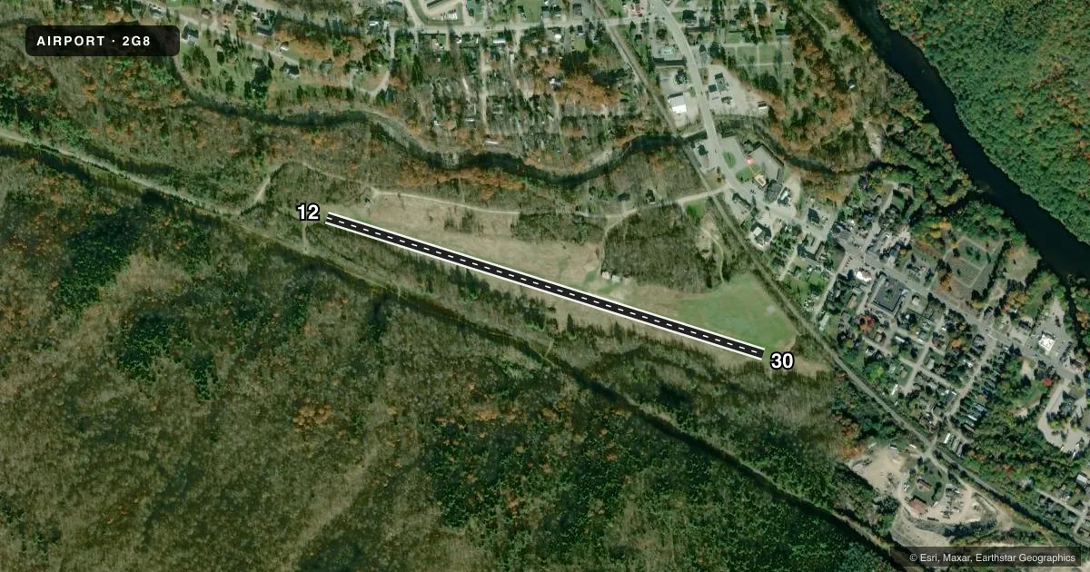
Airport sketch
Runways drawn to scale from FAA survey coordinates, rendered over satellite imagery. Not for navigation.
Approaches & charts
Services on the field
Fuel grades, oxygen, maintenance, ramp storage and lighting — as declared to the FAA by the airport operator.
Fuel & services
- Fuel
- Not available
- Airframe repair
- Not available
- Power plant repair
- Not available
Ramp & ground
- Transient storage
- Tie-down
- Landing fee
- No fee published
- Wind indicator
- Yes
- Segmented circle
- No
Fuel & FBOs
Cheapest 100LL and Jet A on the field and nearby. Always confirm with the FBO before taxi.
Airport notes
Surface conditions, obstructions, local procedures, lighting outages and other notes published with each FAA cycle.
General notes
- RFLG & MAINT OF ACFT IS PROHIBITED.
- ARPT CLSD NOV 1 - MAY 15. OTR TIMES CK NOTAMS OR DURG NML BUS HRS ONLY CALL 603-466-3302, LVE FONE NR & EXP RTRN CALL FOR FICON.
- WILDLIFE ON & INVOF ARPT.
- ARPT OPRD & MAINT BY TOWN OF GORHAM WATER & SEWER DEPT.
- FOR CD CTC BOSTON ARTCC AT 603-879-6859.
- CAMPING PROHIBITED ON ARPT.
Runway surface & condition
- 12/30AER 30 SOFT IN SPRING/HEAVY RAINS.
Approach & departure obstructions
- 12TREES BOTH SIDES OF RWY +50 FT.
- 30TREES BOTH SIDES OF RWY +50 FT.
- 12RWY 12/30 EDGES & ENDS MKD BY YELLOW CONES.
- 12CTLG OBTSN EXCEEDS A 45 DEG SLP.
- 30APCH SLP 10:1 TO DTHR.
Other notes
- NON-COMPLIANCE WITH FAR 157.
- TIEDOWN SPACE AVBL. TIEDOWN ANCHORS RQRD.
- 12/30RWY SFC ROLLING AND UNEVEN.
VFR map & nearby airports
VFR sectional. Tap any ICAO chip to open that airport.
Key facts · 2G8
Answer card- ICAO
- 2G8
- Name
- GORHAM
- Location
- GORHAM, NEW HAMPSHIRE
- Elevation
- 835 ft MSL
- Traffic pattern altitude
- 1,835 ft MSL (1,000 AGL)
- Control tower
- Non-towered (use CTAF)
- Total runways
- 1
- Longest runway
- 12/30 · 2,828 ft
- Published ILS approaches
- 0
- Published frequencies
- 2
- Magnetic variation
- 17°
- Current flight rules
- VFR
- Current wind
- 000° at 0 kt
- Favored runway now
- –
Gorham Airport sits in Gorham, New Hampshire. Field elevation is 835 ft MSL. It has one runway, 12/30, which is 2,828 ft of turf. There is no control tower. CTAF and UNICOM are both 122.8. No ILS approaches are published for the field.
The pattern altitude is not published. Use the standard 1,000 ft AGL unless the current Chart Supplement or airport operator says otherwise. That puts the light aircraft pattern at 1,835 ft MSL based on the field elevation. The airport is closed from November 1 through May 15. At other times, check NOTAMs and call during normal business hours if you need a field condition update. The published number is 603-466-3302.
This is a turf strip with trees on both sides of both runway ends. Runway 30 also has a soft area near the threshold in spring and after heavy rain. The runway edges and ends are marked by yellow cones. Wildlife is also reported on and near the airport. Refueling and maintenance are prohibited, so plan fuel and service stops elsewhere before you arrive. The airport is operated and maintained by the Town of Gorham Water and Sewer Department. For clearance delivery, contact Boston ARTCC at 603-879-6859.