METAR & TAF 0B1
0B1 does not publish a METAR.
Showing the nearest reporting station: KBML (BERLIN RGNL) · 18.1 NM away. Conditions at 0B1 may differ.
METAR · KBML
Observed 11:08Z
KBML 271108Z AUTO 00000KT 7SM SCT001 12/11 A2988 RMK AO2 T01220111 $
- Wind
- 000° @ 0 kt
- Visibility
- 7 SM
- Temp / Dew
- 12°C / 11°C
- Altimeter
- 29.88 inHg
- Clouds
- SCT
- Density alt
- 525 ft
- Ceiling
- Unlimited
- Rules
- VFR
Airport info & contacts
Manager on record, flight service, ARTCC, attendance schedule and pattern altitude — published by the FAA and refreshed every 28 days.
Location
- From city
- 2 NM NW
- VFR sectional
- MONTREAL
- ARTCC
- ZBW · BOSTON
- NOTAM facility
- BGR (NOTAM-D)
Airport manager
- Name
- RANDY AUTREY
- Phone
- 207-381-0202
- Address
- TOWN OF BETHEL, PO BOX 1660, BETHEL ME 04217
Flight service · Hours
- FSS BGR
- BANGOR1-800-WX-BRIEF
- Attendance
- Unattended
Frequencies
Tap any row to copy the frequency to your clipboard.
Runways & pattern
Full pagePattern entry · RWY 14
LEFT TRAFFICRunway end performance
| End | TORA | TODA | ASDA | LDA | VGSI | Approach lights | Obstruction |
|---|---|---|---|---|---|---|---|
| 14 | — | — | — | — | — | — | 18', tree, 296' from thr, 199' R of cntrln, slope 5 |
Declared distances in feet. TORA = takeoff run available, TODA = takeoff distance, ASDA = accelerate-stop, LDA = landing distance.
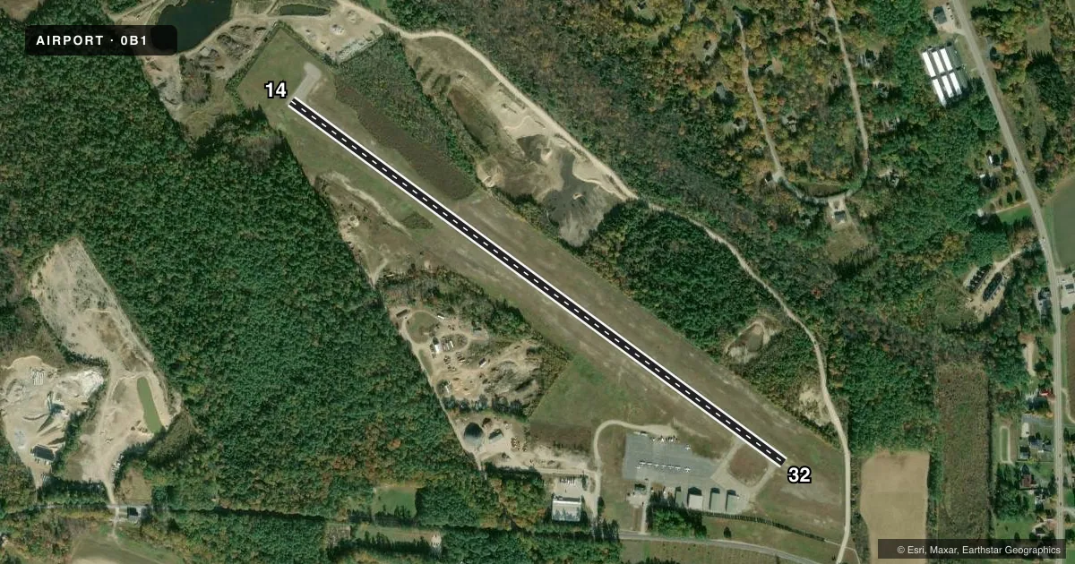
Airport sketch
Runways drawn to scale from FAA survey coordinates, rendered over satellite imagery. Not for navigation.
Approaches & charts
Services on the field
Fuel grades, oxygen, maintenance, ramp storage and lighting — as declared to the FAA by the airport operator.
Fuel & services
- Fuel
- 100LL
- Oxygen (bottled)
- Not available
- Oxygen (bulk)
- Not available
- Airframe repair
- Not available
- Power plant repair
- Not available
Ramp & ground
- Transient storage
- Tie-down
- Landing fee
- No fee published
- Customs
- Not available
- Lighting schedule
- SEE RMK
- Beacon schedule
- SS-SR
- Beacon
- White / Green (civil land)(WG)
- Wind indicator
- Lighted
- Segmented circle
- Yes
Fuel & FBOs
Cheapest 100LL and Jet A on the field and nearby. Always confirm with the FBO before taxi.
Airport notes
Surface conditions, obstructions, local procedures, lighting outages and other notes published with each FAA cycle.
General notes
- UNLGTD MTUS TRRN.
- FOR RWY CONDS OR OTHER INFO, CTC ARPT INFO LINE 207-512-5552.
- PWRD PRCHT ACTVTY OCNLY IN TRML AREA.
- FEES FOR PRKG & TIE-DOWNS. ELEC HOOK-UP AVBL.
- ARPT SFC CONDS UNMON BTN 0200-1300Z DLY.
- UAS WI 3 NM RDS OF ARPT SFC-400 FT AGL DLY, SR-SS.
- TURKEYS & GEESE ON OR INVOF ARPT.
- FOR CD CTC PORTLAND APCH AT 207-874-7320, WHEN APCH CLSD CTC BOSTON ARTCC AT 603-879-6859.
- COLD TEMPERATURE AIRPORT. ALTITUDE CORRECTION REQUIRED AT OR BELOW -22C.
Lighting notes
- ACTVT REIL RWY 32; MIRL RWY 14/32 - CTAF.
Fuel notes
- 100LLSELF-SERVE AVBL 24 HRS WITH CREDIT CARD.
Other notes
- EXISTED PRIOR TO 1959.
- LGTD WINDSOCK AND APN LGTS ON CONSLY AT NGT.
- MANAGERTOWN MGR.. ADDITIONAL CONTACT: RANDY AUTREY - DEPUTY AIRPORT MGR. (207-824-2669)
- MANAGEREMERG (POLICE) 1-800-733-1421.
VFR map & nearby airports
VFR sectional. Tap any ICAO chip to open that airport.
Key facts · 0B1
Answer card- ICAO
- 0B1
- Name
- BETHEL RGNL
- Location
- BETHEL, MAINE
- Elevation
- 674 ft MSL
- Traffic pattern altitude
- 1,674 ft MSL (1,000 AGL)
- Control tower
- Non-towered (use CTAF)
- Total runways
- 1
- Longest runway
- 14/32 · 3,818 ft
- Published ILS approaches
- 0
- Published frequencies
- 3
- Magnetic variation
- 17°
- Current flight rules
- VFR
- Current wind
- 000° at 0 kt
- Favored runway now
- –
Bethel Rgnl Airport sits in Bethel, Maine at 674 ft MSL. It has one runway, 14/32, which is 3,818 ft long and paved with asphalt. There is no control tower, so expect non-towered ops on CTAF 122.9. Pattern altitude is not published. Use the standard 1,000 ft AGL pattern for light piston traffic unless the current Chart Supplement says otherwise. No ILS approaches are published here, so plan with that in mind if the weather is marginal.
The field has on-field FBO service from Bethel Regional Airport. It carries 100LL. Self-serve 100LL is available 24 hours with a credit card. The airport remarks also note parking and tie-down fees. Electric hook-up is available. Runway 32 has REILs. Medium intensity runway lights are on both ends and are controlled by CTAF. Lighted windsock and apron lights stay on at night.
This is a cold temperature airport. Altitude correction is required at or below minus 22 degrees Celsius. Surface conditions are unmonitored between 0200 and 1300 Zulu each day. For a first visit, pay attention to the mountain-valley feel around western Maine. Also plan for the cold-weather performance hit. Check the current FAA Chart Supplement for any noise or operational updates before you go.