METAR & TAF 81B
81B does not publish a METAR.
Showing the nearest reporting station: KLEW (AUBURN/LEWISTON MUNI) · 10.7 NM away. Conditions at 81B may differ.
METAR · KLEW
Observed 09:56Z
KLEW 270956Z AUTO 00000KT 10SM CLR 08/08 A2985 RMK AO2 SLP113 T00830083 PNO $
- Wind
- 000° @ 0 kt
- Visibility
- 10 SM
- Temp / Dew
- 8°C / 8°C
- Altimeter
- 29.85 inHg
- Clouds
- CLR
- Density alt
- -325 ft
- Ceiling
- Unlimited
- Rules
- VFR
Airport info & contacts
Manager on record, flight service, ARTCC, attendance schedule and pattern altitude — published by the FAA and refreshed every 28 days.
Location
- From city
- 2 NM E
- VFR sectional
- MONTREAL
- ARTCC
- ZBW · BOSTON
- NOTAM facility
- BGR (NOTAM-D)
Airport manager
- Name
- TONY CARTER - CO ADMIR
- Phone
- 207-461-5040
- Address
- PO BOX 179, 26 WESTERN AVE, SOUTH PARIS ME 04281
Flight service · Hours
- FSS BGR
- BANGOR1-800-WX-BRIEF
- Attendance
- MON-SAT · 0700-1700
- SUN · Unattended
Frequencies
Tap any row to copy the frequency to your clipboard.
Runways & pattern
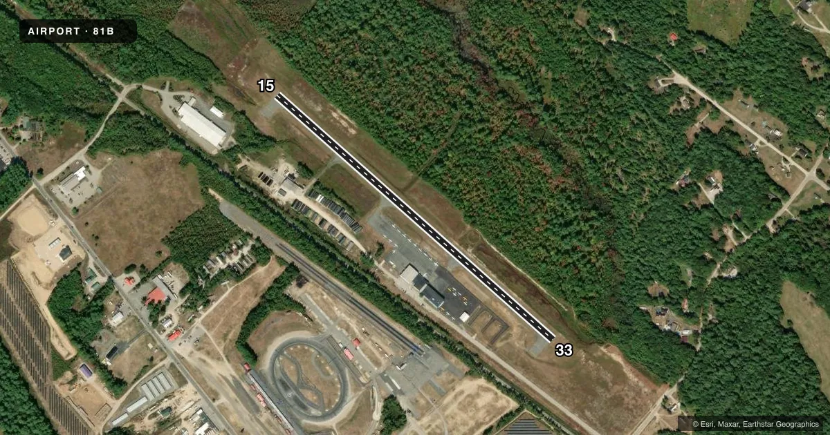
Full pagePattern entry · RWY 15
LEFT TRAFFICAirport sketch
Runways drawn to scale from FAA survey coordinates, rendered over satellite imagery. Not for navigation.
Approaches & charts
Services on the field
Fuel grades, oxygen, maintenance, ramp storage and lighting — as declared to the FAA by the airport operator.
Fuel & services
- Fuel
- 100LL
- Oxygen (bottled)
- HIGH/LOW
- Oxygen (bulk)
- HIGH/LOW
- Airframe repair
- Major
- Power plant repair
- Major
- Other services
- INSTR,RNTL
Ramp & ground
- Transient storage
- Tie-down
- Hangar
- Landing fee
- No fee published
- Lighting schedule
- SEE RMK
- Beacon schedule
- SS-SR
- Beacon
- White / Green (civil land)(WG)
- Wind indicator
- Lighted
- Segmented circle
- Yes
Fuel & FBOs
Cheapest 100LL and Jet A on the field and nearby. Always confirm with the FBO before taxi.
Airport notes
Surface conditions, obstructions, local procedures, lighting outages and other notes published with each FAA cycle.
General notes
- RWY 15/33 HAS 2 IN DROP-OFFS LCTD ON ALL SIDES & THLDS.
- WILDLIFE ON & INVOF ARPT.
- FOR CD CTC PORTLAND APCH AT 207-874-7320, WHEN APCH CLSD CTC BOSTON ARTCC AT 603-879-6859.
Lighting notes
- ACTVT MIRL RWY 15/33 - CTAF.
Fuel notes
- 100LLSELF-SVC 100LL AVBL 24 HRS.
Approach & departure obstructions
- 156-10 FT TREES, 75-125 FT FM THR, 170-185 FT RITE OF CNTRLN.
Other notes
- FOR MAINT CALL 207-539-6065.
- THIS AIRPORT HAS BEEN SURVEYED BY THE NATIONAL GEODETIC SURVEY.
- VFR ONLY.
- ADDNL SECTIONAL CHART NEW YORK.
- FOR MAINT CALL 207-539-6065.
- OWNEREMERG FONE: 207-743-6336 OXFORD COUNTY EMA.
VFR map & nearby airports
VFR sectional. Tap any ICAO chip to open that airport.
Key facts · 81B
Answer card- ICAO
- 81B
- Name
- OXFORD COUNTY RGNL
- Location
- OXFORD, MAINE
- Elevation
- 345 ft MSL
- Traffic pattern altitude
- 1,345 ft MSL (1,000 AGL)
- Control tower
- Non-towered (use CTAF)
- Total runways
- 1
- Longest runway
- 15/33 · 2,997 ft
- Published ILS approaches
- 0
- Published frequencies
- 4
- Magnetic variation
- 17°
- Current flight rules
- VFR
- Current wind
- 000° at 0 kt
- Favored runway now
- –
Oxford County Rgnl Airport (81B) sits in Oxford, Maine at 345 ft MSL. It has one runway, 15/33, which is 2,997 ft long. There is no control tower. Pattern altitude is not published. For light piston operations, use 1,000 ft AGL unless the current Chart Supplement says otherwise. That puts the pattern at 1,345 ft MSL here.
No ILS approaches are published. This is a VFR-only field. Clearance delivery is handled through Portland Approach when needed. If Approach is closed, use Boston ARTCC. The airport uses CTAF 122.8 for CTAF and UNICOM. Medium intensity runway lights for 15/33 are activated on CTAF.
Self-serve 100LL is available 24 hours. No on-field FBOs are listed. Wildlife is reported on and near the airport. Runway 15/33 has two-inch drop-offs on all sides and at the thresholds. There are also 6 to 10 ft trees near the threshold area for runway 15, offset to the right of centerline. That makes a stabilized approach important, especially with the field’s short runway and no published instrument approach. First-time pilots should plan for a straightforward VFR arrival, verify the current Chart Supplement and be ready for the local terrain and obstacle picture before turning final.