METAR & TAF 03M
03M does not publish a METAR.
Showing the nearest reporting station: KAUG (AUGUSTA STATE) · 3.9 NM away. Conditions at 03M may differ.
METAR · KAUG
Observed 10:53Z
KAUG 271053Z AUTO 00000KT 10SM CLR 14/12 A2986 RMK AO2 SLP110 T01390117
- Wind
- 000° @ 0 kt
- Visibility
- 10 SM
- Temp / Dew
- 14°C / 12°C
- Altimeter
- 29.86 inHg
- Clouds
- CLR
- Density alt
- 159 ft
- Ceiling
- Unlimited
- Rules
- VFR
Airport info & contacts
Manager on record, flight service, ARTCC, attendance schedule and pattern altitude — published by the FAA and refreshed every 28 days.
Location
- From city
- 4 NM E
- VFR sectional
- MONTREAL
- ARTCC
- ZBW · BOSTON
- NOTAM facility
- BGR (NOTAM-D)
Airport manager
- Name
- ZACH STEWART
- Phone
- 207-395-6741
- Address
- 77 TURTLE RUN RD, WINTHROP ME 04364
Flight service · Hours
- FSS BGR
- BANGOR1-800-WX-BRIEF
- Attendance
- 0700-2100
Frequencies
Tap any row to copy the frequency to your clipboard.
Runways & pattern
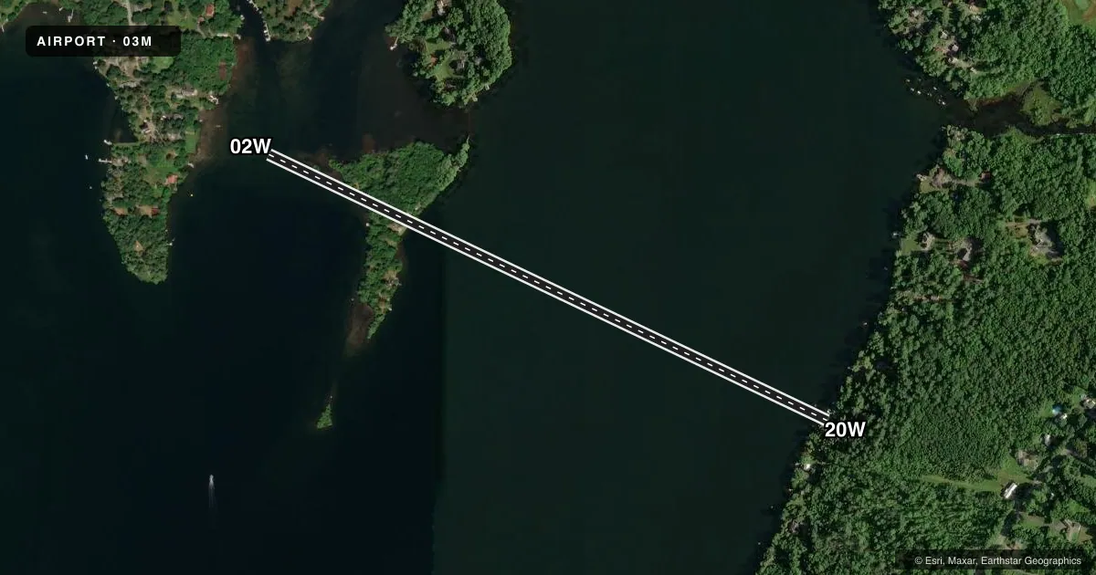
Full pagePattern entry · RWY 02W
LEFT TRAFFICAirport sketch
Runways drawn to scale from FAA survey coordinates, rendered over satellite imagery. Not for navigation.
Approaches & charts
Services on the field
Fuel grades, oxygen, maintenance, ramp storage and lighting — as declared to the FAA by the airport operator.
Fuel & services
- Fuel
- Not available
Ramp & ground
- Transient storage
- Not published
- Wind indicator
- No
- Segmented circle
- No
Fuel & FBOs
Cheapest 100LL and Jet A on the field and nearby. Always confirm with the FBO before taxi.
Airport notes
Surface conditions, obstructions, local procedures, lighting outages and other notes published with each FAA cycle.
General notes
- DAYTIME USE ONLY.
- FOR CD CTC PORTLAND APCH AT 207-874-7320, WHEN APCH CLSD CTC BOSTON ARTCC AT 603-879-6859.
- HVY BOAT TFC ON WKENDS.
Runway surface & condition
- 02W/20WRWY 02W END E OF LIGHTHOUSE; RWY 20W END E OF S TIP HERSEY ISLAND.
Other notes
- PRVDD VFR.
- DOCK IS AVBL.
- MANAGERFOR EMERG AFT HRS 1-800-532-6892 OR 207-395-6941.
VFR map & nearby airports
VFR sectional. Tap any ICAO chip to open that airport.
Key facts · 03M
Answer card- ICAO
- 03M
- Name
- LAKESIDE LODGE AND MARINA
- Location
- EAST WINTHROP, MAINE
- Elevation
- 165 ft MSL
- Traffic pattern altitude
- 1,165 ft MSL (1,000 AGL)
- Control tower
- Non-towered (use CTAF)
- Total runways
- 1
- Longest runway
- 02W/20W · 3,800 ft
- Published ILS approaches
- 0
- Published frequencies
- 1
- Magnetic variation
- 18°
- Current flight rules
- VFR
- Current wind
- 000° at 0 kt
- Favored runway now
- –
Lakeside Lodge and Marina (03M) sits in East Winthrop, Maine at 165 ft MSL. It has one runway. The longest is 02W/20W on water at 3,800 ft. This is a non-towered field with CTAF 122.9. No ILS approaches are published. Pattern altitude is not published, so use the standard 1,000 ft AGL for light piston traffic unless the current Chart Supplement says otherwise.
The field is for daytime use only. Heavy boat traffic occurs on weekends, so expect extra surface activity on the water. The published remarks also note that runway 02W ends east of the lighthouse. Runway 20W ends east of the south tip of Hersey Island. That matters when you are lining up visually.
There are no on-field FBOs listed. Check with the airport operator or the FBO directly by phone before arrival if you need current services. For emergencies after hours, the published contacts are 1-800-532-6892 and 207-395-6941. Clearance delivery is handled through Portland Approach at 207-874-7320. When approach is closed, contact Boston ARTCC at 603-879-6859. The airport also notes that VFR services are provided. Expect a small-field, water-runway environment with no tower and no published instrument approach support.