METAR & TAF KIWI
Current METAR
Observed 11:53Z
KIWI 271153Z AUTO 00000KT 10SM CLR 18/13 A2987 RMK AO2 SLP116 T01780133 10178 20083 53007
- Wind
- 000° @ 0 kt
- Visibility
- 10 SM
- Temp / Dew
- 18°C / 13°C
- Altimeter
- 29.87 inHg
- Clouds
- CLR
- Density alt
- 509 ft
- Ceiling
- Unlimited
- Rules
- VFR
Airport info & contacts
Manager on record, flight service, ARTCC, attendance schedule and pattern altitude — published by the FAA and refreshed every 28 days.
Location
- From city
- 3 NM SW
- VFR sectional
- NEW YORK
- ARTCC
- ZBW · BOSTON
- NOTAM facility
- IWI (NOTAM-D)
Airport manager
- Name
- RICK TETREV
- Phone
- (207) 882-5475
- Address
- 96 CHEWONKI NECK ROAD, 51 BATH RD, WISCASSET ME 04578
Flight service · Hours
- FSS BGR
- BANGOR1-800-WX-BRIEF
- Attendance
- MAY-LABOR DAY · 0800-1600
- SEP-NOV · FRI-SUN · 0900-1600
- JAN-MAR · NOT ATTENDED
- DEC-APR · SAT-SUN · 1000-1400
Frequencies
Tap any row to copy the frequency to your clipboard.
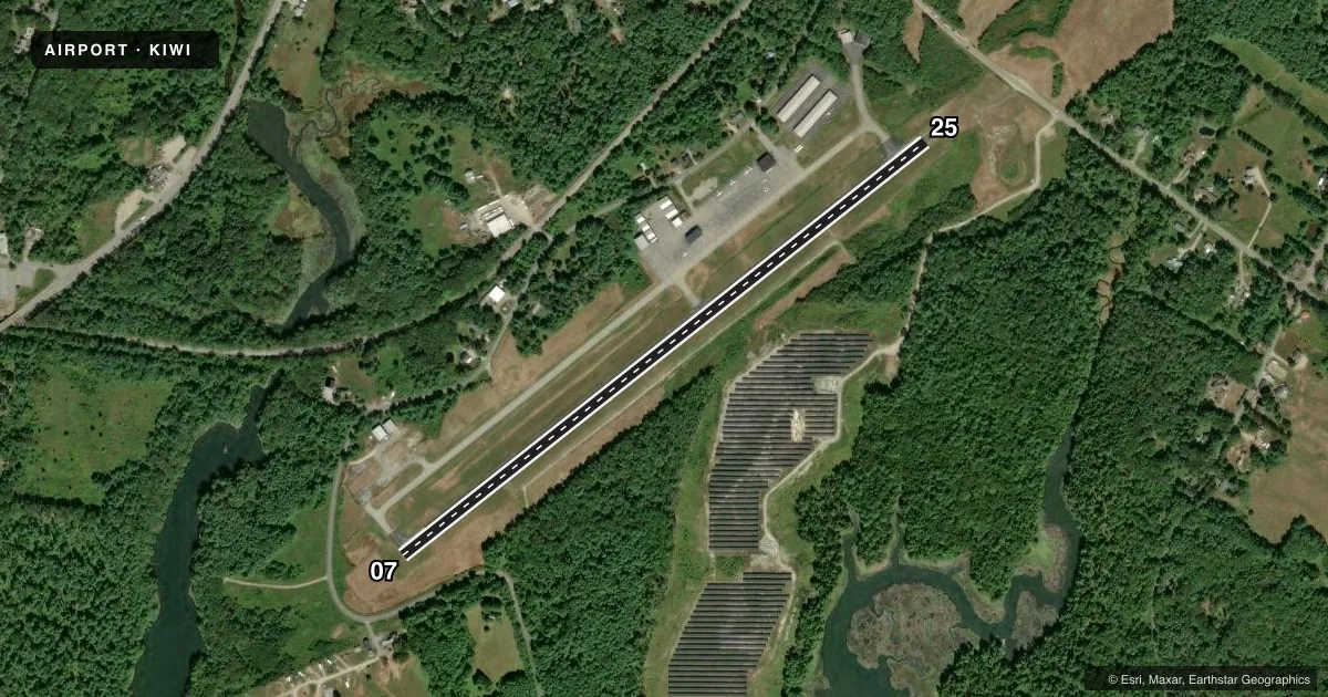
Runways & pattern
Full pagePattern entry · RWY 07
LEFT TRAFFICRunway end performance
| End | TORA | TODA | ASDA | LDA | VGSI | Approach lights | Obstruction |
|---|---|---|---|---|---|---|---|
| 07 | — | — | — | — | PAPI 4-box right(4°) | — | 12', pole, 262' from thr, 253' R of cntrln, slope 5 |
| 25 | — | — | — | — | PAPI 4-box left(3.5°) | — | 5', tree, 255' from thr, 200' R of cntrln, slope 11 |
Declared distances in feet. TORA = takeoff run available, TODA = takeoff distance, ASDA = accelerate-stop, LDA = landing distance.
Airport sketch
Runways drawn to scale from FAA survey coordinates, rendered over satellite imagery. Not for navigation.
Approaches & charts
Services on the field
Fuel grades, oxygen, maintenance, ramp storage and lighting — as declared to the FAA by the airport operator.
Fuel & services
- Fuel
- 100LLA1+
- Oxygen (bottled)
- Not available
- Oxygen (bulk)
- Not available
- Airframe repair
- Not available
- Power plant repair
- Not available
- Other services
- CHTR
Ramp & ground
- Transient storage
- Tie-down
- Hangar
- Landing fee
- No fee published
- Customs
- Not available
- Lighting schedule
- SEE RMK
- Beacon schedule
- SS-SR
- Beacon
- White / Green (civil land)(WG)
- Wind indicator
- Lighted
- Segmented circle
- Yes
Fuel & FBOs
Cheapest 100LL and Jet A on the field and nearby. Always confirm with the FBO before taxi.
Airport notes
Surface conditions, obstructions, local procedures, lighting outages and other notes published with each FAA cycle.
General notes
- NOISE SENSITIVE AREA SOUTHWEST OFF EOR 07, CLIMB STRAIGHT OUT TO 700 FT AGL.
- DEER AND WILDLIFE ON & INVOF ARPT.
- RWY 7 APCH OBSTN LGTS ON 60 FT. POLES ALG RIGHT SIDE OF APCH LCTD IN 60 FT. TO 70 FT. TALL TREES.
- FOR CD CTC PORTLAND APCH AT 207-874-7320. WHEN PORTLAND APCH CLSD, CTC BOSTON ARTCC AT 603-879-6859.
Lighting notes
- ACTVT REIL RWY 25; PAPI RWY 07 & 25; MIRL RWY 07/25 - CTAF.
Fuel notes
- 100LL24 HR CREDIT CARD FUEL OPN.
Approach & departure obstructions
- 25SCRUB BRUSH 60-100 FT FM RWY END, 80-200 FT R; SCRUB BRUSH 20-43 FT FM RWY END, 140-210 FT L.
Other notes
- FILED FOR RECORD PURPOSES ONLY.
- CALL 207-882-5475 FOR AVBL OF HNGRS.
- MANAGEREMAIL: AIRPORT@WISCASSET.ORG. EMERG CTC: 207-882-8202 (TOWN DISPATCHER).
VFR map & nearby airports
VFR sectional. Tap any ICAO chip to open that airport.
Key facts · KIWI
Answer card- ICAO
- KIWI
- Name
- WISCASSET
- Location
- WISCASSET, MAINE
- Elevation
- 70.2 ft MSL
- Traffic pattern altitude
- 1,070.2 ft MSL (1,000 AGL)
- Control tower
- Non-towered (use CTAF)
- Total runways
- 1
- Longest runway
- 07/25 · 3,397 ft
- Published ILS approaches
- 0
- Published frequencies
- 6
- Magnetic variation
- 18°
- Current flight rules
- VFR
- Current wind
- 000° at 0 kt
- Favored runway now
- –
Wiscasset Airport sits in Wiscasset, Maine. Field elevation is 70.2 ft MSL. It has one runway, 07/25, which is 3,397 ft long and asphalt. There is no control tower. Traffic pattern altitude is not published, so use the standard 1,000 ft AGL for light piston unless the current Chart Supplement says otherwise.
No ILS approaches are published here. For IFR work, plan around the Portland approach frequencies listed for the area and verify current procedures before departure. The airport is close enough to the coast and local traffic flow can matter, so keep your scan tight on arrival and departure. Runway 25 has runway end identifier lights. Runways 07 and 25 have PAPI. Medium intensity runway lights are on 07/25 and are controlled by CTAF.
Wiscasset Airport has one on-field FBO, Wiscasset Airport. It carries 100LL and Jet A. Fuel is available 24 hours by credit card. The published remarks also call out deer and other wildlife in the area. There is scrub brush near both runway ends, with the closest growth near the runway 07 end. For runway 07 departures, the published note says to climb straight out to 700 ft AGL because of a noise-sensitive area southwest of the departure end.