METAR & TAF KRKD
Current METAR
Observed 23:56Z
KRKD 232356Z AUTO 00000KT 10SM CLR 18/17 A2982 RMK AO2 SLP096 6//// T01780167 10206 20178 53002
- Wind
- 000° @ 0 kt
- Visibility
- 10 SM
- Temp / Dew
- 18°C / 17°C
- Altimeter
- 29.82 inHg
- Clouds
- CLR
- Density alt
- 553 ft
- Ceiling
- Unlimited
- Rules
- VFR
Airport info & contacts
Manager on record, flight service, ARTCC, attendance schedule and pattern altitude — published by the FAA and refreshed every 28 days.
Location
- From city
- 3 NM S
- VFR sectional
- MONTREAL
- ARTCC
- ZBW · BOSTON
- NOTAM facility
- RKD (NOTAM-D)
Airport manager
- Name
- JACOB JOHNSON
- Phone
- 207-701-1715
- Address
- 5 AIRPORT RD, OWLS HEAD ME 04854
Flight service · Hours
- FSS BGR
- BANGOR1-800-WX-BRIEF
- Attendance
- MON-FRI · 0600-1700
Frequencies
Tap any row to copy the frequency to your clipboard.
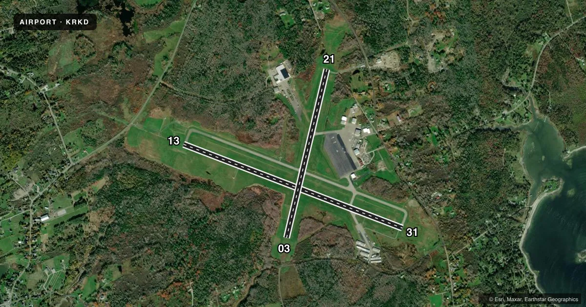
Runways & pattern
Full pagePattern entry · RWY 13
LEFT TRAFFIC| Runway | Heading (°M) | Length | Surface | Traffic |
|---|---|---|---|---|
| 13/31 | 93° / 273° | 5,412 ft | ASPH | Standard L |
| 03/21 | 355° / 175° | 4,000 ft | ASPH | Standard L |
Runway end performance
| End | TORA | TODA | ASDA | LDA | VGSI | Approach lights | Obstruction |
|---|---|---|---|---|---|---|---|
| 13 | 5,412' | 5,412' | 5,412' | 5,012' | PAPI 4-box right(3°) | MALSR | — |
| 31 | 5,412' | 5,412' | 5,412' | 5,412' | PAPI 4-box left(3°) | — | 40', trees, 450' from thr, 475' R of cntrln, slope 6 |
| 03 | 4,000' | 4,000' | 4,000' | 4,000' | PAPI 4-box left(3°) | — | 26', trees, 357' from thr, 270' R of cntrln, slope 6 |
| 21 | 4,000' | 4,000' | 4,000' | 4,000' | — | — | 50', trees, 525' from thr, 250' R of cntrln, slope 6 |
Declared distances in feet. TORA = takeoff run available, TODA = takeoff distance, ASDA = accelerate-stop, LDA = landing distance.
Airport sketch
Runways drawn to scale from FAA survey coordinates, rendered over satellite imagery. Not for navigation.
Approaches & charts
ILS · 1
Services on the field
Fuel grades, oxygen, maintenance, ramp storage and lighting — as declared to the FAA by the airport operator.
Fuel & services
- Fuel
- 100LLA
- Oxygen (bottled)
- Low pressure
- Oxygen (bulk)
- Low pressure
- Airframe repair
- Major
- Power plant repair
- Major
- Other services
- AFRT,CHTR,INSTR,RNTL
Ramp & ground
- Transient storage
- Tie-down
- Hangar
- Landing fee
- No fee published
- Customs
- Not available
- Lighting schedule
- SEE RMK
- Beacon schedule
- SS-SR
- Beacon
- White / Green (civil land)(WG)
- Wind indicator
- Lighted
- Segmented circle
- Yes
Fuel & FBOs
Cheapest 100LL and Jet A on the field and nearby. Always confirm with the FBO before taxi.
Airport notes
Surface conditions, obstructions, local procedures, lighting outages and other notes published with each FAA cycle.
General notes
- DEER & SEAGULLS ON & INVOF ARPT.
- VOLUNTARY NGT CUFREW IN EFCT 2230-0600.
- NOISE ABATEMENT PROCS IN EFCT, CALL 207-596-0617 OR VISIT WEBSITE FOR SPECIFIC INSTRUCTIONS.
- FOR CD WHEN APCH CLSD CTC BOSTON ARTCC AT 603-879-6859.
Lighting notes
- ACTVT MALSR RWY 13; REIL RWY 03 & 31; PAPI RWY 03, 13 & 31; HIRL RWY 13/31; MIRL RWY 03/21 - CTAF.
Other notes
- EXISTED PRIOR TO 1959.
- CALL FBO 207-594-2171 FOR AVBL.
- 1ARPT MAY BE UNATNDD FM 2200-0600.
VFR map & nearby airports
VFR sectional. Tap any ICAO chip to open that airport.
Key facts · KRKD
Answer card- ICAO
- KRKD
- Name
- KNOX COUNTY RGNL
- Location
- ROCKLAND, MAINE
- Elevation
- 55.4 ft MSL
- Traffic pattern altitude
- 1,055.4 ft MSL (1,000 AGL)
- Control tower
- Non-towered (use CTAF)
- Total runways
- 2
- Longest runway
- 13/31 · 5,412 ft
- Published ILS approaches
- 1
- Published frequencies
- 5
- Magnetic variation
- 18°
- Current flight rules
- VFR
- Current wind
- 000° at 0 kt
- Favored runway now
- –
Knox County Rgnl sits in Rockland, Maine. Field elevation is 55.4 ft MSL. The airport has two asphalt runways. The longest is 5,412 ft on runway 13/31. There is no control tower, so use CTAF 123.05 for self-announce traffic. The published pattern altitude is not listed, so use the standard 1,000 ft AGL for light piston traffic unless the current Chart Supplement says otherwise.
The field has one ILS approach to runway 13. Lighting is good to know before a night arrival. MALSR is on runway 13. REIL is on runways 03 and 31. PAPI is available on runways 03, 13 and 31. Runway 13/31 has high intensity lighting. Runway 03/21 has medium intensity lighting. Published remarks also say the airport may be unattended from 2200 to 0600. There is a voluntary night curfew from 2230 to 0600. Noise abatement procedures are in effect. Check the current Chart Supplement before you go.
Downeast Air is on the field. It carries 100LL, Jet A and Jet A Prist. Deer and seagulls are reported on and near the airport. Keep that in mind on taxi, takeoff and landing. For a first visit, the main things are the uncontrolled pattern, the night lighting setup on runway 13 and the published noise and curfew guidance.