METAR & TAF KBST
KBST does not publish a METAR.
Showing the nearest reporting station: KRKD (KNOX COUNTY RGNL) · 21.3 NM away. Conditions at KBST may differ.
METAR · KRKD
Observed 11:56Z
KRKD 271156Z AUTO 03004KT 10SM CLR 18/12 A2986 RMK AO2 SLP111 6//// 7//// T01780117 10178 20067 53007
- Wind
- 030° @ 4 kt
- Visibility
- 10 SM
- Temp / Dew
- 18°C / 12°C
- Altimeter
- 29.86 inHg
- Clouds
- CLR
- Density alt
- 679 ft
- Ceiling
- Unlimited
- Rules
- VFR
Airport info & contacts
Manager on record, flight service, ARTCC, attendance schedule and pattern altitude — published by the FAA and refreshed every 28 days.
Location
- From city
- 1 NM SW
- VFR sectional
- MONTREAL
- ARTCC
- ZBW · BOSTON
- NOTAM facility
- BGR (NOTAM-D)
Airport manager
- Name
- KENN ORTMANN
- Phone
- 603-970-1947
- Address
- 22 WRIGHT BROTHERS DR, C/O 131 CHURCH ST, BELFAST ME 04915
Flight service · Hours
- FSS BGR
- BANGOR1-800-WX-BRIEF
- Attendance
- IREG
Frequencies
Tap any row to copy the frequency to your clipboard.
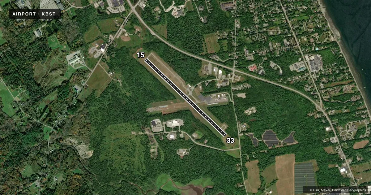
Runways & pattern
Full pagePattern entry · RWY 33
LEFT TRAFFICAirport sketch
Runways drawn to scale from FAA survey coordinates, rendered over satellite imagery. Not for navigation.
Approaches & charts
Services on the field
Fuel grades, oxygen, maintenance, ramp storage and lighting — as declared to the FAA by the airport operator.
Fuel & services
- Fuel
- 100LLA+
- Oxygen (bottled)
- Not available
- Oxygen (bulk)
- Not available
- Airframe repair
- Major
- Power plant repair
- Major
- Other services
- CHTR,INSTR
Ramp & ground
- Transient storage
- Tie-down
- Hangar
- Landing fee
- No fee published
- Customs
- Not available
- Lighting schedule
- SEE RMK
- Beacon schedule
- SS-SR
- Beacon
- White / Green (civil land)(WG)
- Wind indicator
- Lighted
- Segmented circle
- Yes
Fuel & FBOs
Cheapest 100LL and Jet A on the field and nearby. Always confirm with the FBO before taxi.
Airport notes
Surface conditions, obstructions, local procedures, lighting outages and other notes published with each FAA cycle.
General notes
- AWOS AVBL - CTAF 2 CLICKS OR 207-930-7071.
- DEER & BIRDS ON & INVOF ARPT.
- SFC COND RPRTD DAILY 1400-2200Z DEC-MAR.
- FOR CD CTC BANGOR APCH AT 207-561-2500 EXTN 1.
- 800X30 PARL TURF LNG AREA E OF RWY & N OF TWY B. CALL 603-970-1947 FOR WINT AVBL.
- FAA WX CAMERA INFO AVBL AT HTTPS://WEATHERCAMS.FAA.GOV/MAP/-69.61024,44.01514,-67.21384,44.80289/CAMERASITE/600/DETAILS/CAMERA.
- LNDG FEE WAIVED WITH FUEL PURCHASE - CTC AMGR.
Lighting notes
- ACTVT REIL RWY 15 & 33; MIRL RWY 15/33 - CTAF.
Approach & departure obstructions
- 3380 FT TALL OBSTN LGTS ALG BOTH SIDES OF PRI SFC AT EDGE OF TREE LINE.
Other notes
- EXISTED PRIOR TO 1959.
- CALL AHD FOR AVBL 603-970-1947.
- 1CALL 603-970-1947 TO CTC AMGR.
- MANAGERSEND ALL MGR CORRESPONDANCE TO CITY HALL 131 CHURCH ST. BELFAST, ME 04915.
VFR map & nearby airports
VFR sectional. Tap any ICAO chip to open that airport.
Key facts · KBST
Answer card- ICAO
- KBST
- Name
- BELFAST MUNI
- Location
- BELFAST, MAINE
- Elevation
- 197.6 ft MSL
- Traffic pattern altitude
- 1,197.6 ft MSL (1,000 AGL)
- Control tower
- Non-towered (use CTAF)
- Total runways
- 1
- Longest runway
- 15/33 · 4,000 ft
- Published ILS approaches
- 0
- Published frequencies
- 4
- Magnetic variation
- 18°
- Current flight rules
- VFR
- Current wind
- 030° at 4 kt
- Favored runway now
- RWY 33
Belfast Muni sits in Belfast, Maine. The field elevation is 197.6 ft MSL. It has one runway, 15/33, with a longest length of 4,000 ft. There is no control tower. No ILS approaches are published here.
Pattern altitude is not published. Use 1,000 ft AGL for light piston traffic unless the current FAA Chart Supplement says otherwise. Bangor Approach handles clearance delivery. The published frequencies include Bangor Approach on 118.925 and 239.3. CTAF and UNICOM are both on 122.975. AWOS is available on CTAF by keying the mic twice or by calling the listed weather number.
The on-field FBO is Belfast Municipal Airport. It carries 100LL and Jet A with Prist. Call ahead before you go. The published remarks also note that the landing fee is waived with a fuel purchase. Runway end identifier lights are active on 15 and 33. Medium intensity runway lights are also on 15 and 33 and are controlled by CTAF. Watch for deer and birds in the area. There is also an 80 ft obstruction with lights near the tree line by runway 33. That makes the departure end worth a close look on the roll and climb out.