METAR & TAF 57B
57B does not publish a METAR.
Showing the nearest reporting station: KRKD (KNOX COUNTY RGNL) · 16.7 NM away. Conditions at 57B may differ.
METAR · KRKD
Observed 16:56Z
KRKD 271656Z AUTO 17007KT 10SM CLR 22/13 A2983 RMK AO2 SLP101 T02220128
- Wind
- 170° @ 7 kt
- Visibility
- 10 SM
- Temp / Dew
- 22°C / 13°C
- Altimeter
- 29.83 inHg
- Clouds
- CLR
- Density alt
- 1,061 ft
- Ceiling
- Unlimited
- Rules
- VFR
Airport info & contacts
Manager on record, flight service, ARTCC, attendance schedule and pattern altitude — published by the FAA and refreshed every 28 days.
Location
- From city
- 1 NM W
- VFR sectional
- HALIFAX
- ARTCC
- ZBW · BOSTON
- NOTAM facility
- BGR (NOTAM-D)
Airport manager
- Name
- JANET R. ANDERSON
- Phone
- 207-734-2253
- Address
- PO BOX 76, ISLESBORO ME 04848
Flight service · Hours
- FSS BGR
- BANGOR1-800-WX-BRIEF
- Attendance
- Unattended
Frequencies
Tap any row to copy the frequency to your clipboard.
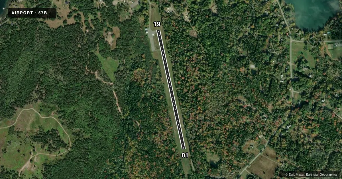
Runways & pattern
Full pagePattern entry · RWY 19
LEFT TRAFFICRunway end performance
| End | TORA | TODA | ASDA | LDA | VGSI | Approach lights | Obstruction |
|---|---|---|---|---|---|---|---|
| 01 | — | — | — | — | — | — | 50', trees, 201' from thr, 90' R of cntrln, slope 0 |
| 19 | — | — | — | — | — | — | 10', road, 201' from thr, 107' R of cntrln, slope 0 |
Declared distances in feet. TORA = takeoff run available, TODA = takeoff distance, ASDA = accelerate-stop, LDA = landing distance.
Airport sketch
Runways drawn to scale from FAA survey coordinates, rendered over satellite imagery. Not for navigation.
Approaches & charts
Services on the field
Fuel grades, oxygen, maintenance, ramp storage and lighting — as declared to the FAA by the airport operator.
Fuel & services
- Fuel
- Not available
- Oxygen (bulk)
- Not available
- Airframe repair
- Not available
- Power plant repair
- Not available
Ramp & ground
- Transient storage
- Tie-down
- Landing fee
- No fee published
- Customs
- Not available
- Wind indicator
- Yes
- Segmented circle
- No
Fuel & FBOs
Cheapest 100LL and Jet A on the field and nearby. Always confirm with the FBO before taxi.
Airport notes
Surface conditions, obstructions, local procedures, lighting outages and other notes published with each FAA cycle.
General notes
- ARPT CLSD NGTS, DAYTIME USE ONLY.
- DEER ON & INVOF ARPT.
- NO TGL OPS.
- NOISE ABATEMENT - MNTN RWY HDG TO 1000 FT AGL.
- HELIPAD: NW CORNER OF RAMP.
- FOR CD CTC BANGOR APCH AT 207-561-2500 EXTN 1.
Approach & departure obstructions
- 0135-45 FT TREES, 0- 200 FT FM THR, 90-125 FT L OF CNTRLN AND 120-125 FT L AND R OF CNTRLN.
- 1910 FT ROAD, 107 FT R OF CNTRLN; 45 FT TREES 100-200 FT FM THR, 120 FT R OF CNTRLN; 10-20 FT BRUSH 100-200 FT FM THR, 105 FT L OF CNTRLN.
- 01APCH RATIO 0:1 TO DTHR DUE TO 35 FT TREE, 0 FT FM DTHR, 120 FT L.
Other notes
- THIS AIRPORT HAS BEEN SURVEYED BY THE NATIONAL GEODETIC SURVEY.
- VFR OPS ONLY.
- MANAGERTOWN MGR OF ISLEBORO.
VFR map & nearby airports
VFR sectional. Tap any ICAO chip to open that airport.
Key facts · 57B
Answer card- ICAO
- 57B
- Name
- ISLESBORO
- Location
- ISLESBORO, MAINE
- Elevation
- 88.3 ft MSL
- Traffic pattern altitude
- 1,088.3 ft MSL (1,000 AGL)
- Control tower
- Non-towered (use CTAF)
- Total runways
- 1
- Longest runway
- 01/19 · 2,400 ft
- Published ILS approaches
- 0
- Published frequencies
- 2
- Magnetic variation
- 18°
- Current flight rules
- VFR
- Current wind
- 170° at 7 kt
- Favored runway now
- RWY 19
Islesboro Airport sits in Islesboro, Maine. Field elevation is 88.3 ft MSL. It has one runway, 01/19, which is 2,400 ft long and paved with asphalt. There is no control tower. The airport is for daytime use only. It is closed at night. VFR operations only are published.
No ILS approaches are published here. Pattern altitude is not published in the facts. Use the standard 1,000 ft AGL for light piston traffic unless the current FAA Chart Supplement says otherwise. That puts the pattern at about 1,088 ft MSL based on the listed field elevation. Noise abatement calls for runway heading to 1,000 ft AGL. No touch-and-go operations are permitted.
There are no on-field FBOs listed. Check with the airport operator or the FBO directly by phone before arrival for current services. Bangor Approach handles clearance delivery by phone at the number in the Chart Supplement. Watch for deer on and near the airport. Runway 19 has nearby trees, brush and a road off the right side. Runway 01 has trees near the threshold and a displaced-threshold limitation tied to an obstacle. If you are planning a first visit, treat this as a short, daytime-only island strip with published obstacle notes and no instrument backup.