METAR & TAF 93B
93B does not publish a METAR.
Showing the nearest reporting station: KRKD (KNOX COUNTY RGNL) · 19.3 NM away. Conditions at 93B may differ.
METAR · KRKD
Observed 12:56Z
KRKD 271256Z AUTO 04006KT 10SM CLR 19/12 A2986 RMK AO2 SLP110 T01940117
- Wind
- 040° @ 6 kt
- Visibility
- 10 SM
- Temp / Dew
- 19°C / 12°C
- Altimeter
- 29.86 inHg
- Clouds
- CLR
- Density alt
- 594 ft
- Ceiling
- Unlimited
- Rules
- VFR
Airport info & contacts
Manager on record, flight service, ARTCC, attendance schedule and pattern altitude — published by the FAA and refreshed every 28 days.
Location
- From city
- 1 NM NW
- VFR sectional
- HALIFAX
- ARTCC
- ZBW · BOSTON
- NOTAM facility
- BGR (NOTAM-D)
Airport manager
- Name
- KATHLEEN BILLING
- Phone
- 207-367-2351
- Address
- PO BOX 9, STONINGTON ME 04681
Flight service · Hours
- FSS BGR
- BANGOR1-800-WX-BRIEF
- Attendance
- Unattended
Frequencies
Tap any row to copy the frequency to your clipboard.
Runways & pattern
Full pagePattern entry · RWY 07
LEFT TRAFFICRunway end performance
| End | TORA | TODA | ASDA | LDA | VGSI | Approach lights | Obstruction |
|---|---|---|---|---|---|---|---|
| 07 | — | — | — | — | — | — | 35', trees, 201' from thr, 50' R of cntrln, slope 0 |
| 25 | — | — | — | — | — | — | 60', trees, 201' from thr, 90' R of cntrln, slope 0 |
Declared distances in feet. TORA = takeoff run available, TODA = takeoff distance, ASDA = accelerate-stop, LDA = landing distance.
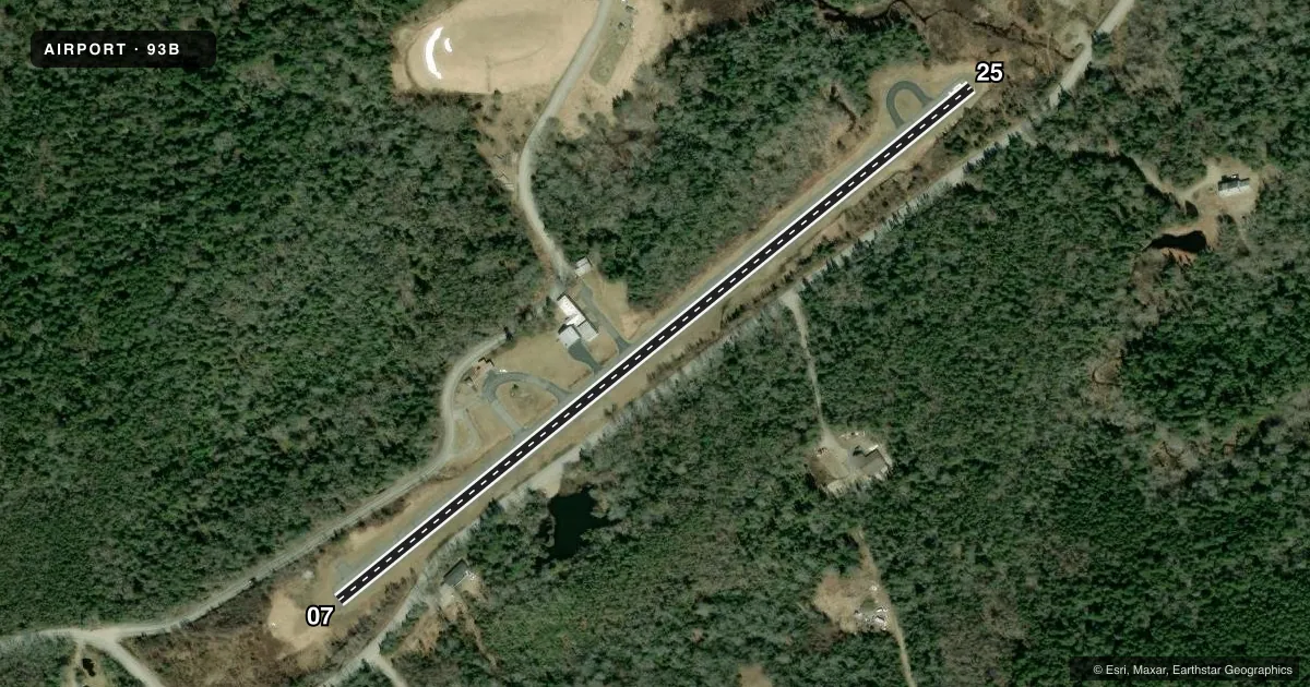
Airport sketch
Runways drawn to scale from FAA survey coordinates, rendered over satellite imagery. Not for navigation.
Approaches & charts
Services on the field
Fuel grades, oxygen, maintenance, ramp storage and lighting — as declared to the FAA by the airport operator.
Fuel & services
- Fuel
- Not available
- Oxygen (bottled)
- Not available
- Oxygen (bulk)
- Not available
- Airframe repair
- Not available
- Power plant repair
- Not available
Ramp & ground
- Transient storage
- Tie-down
- Landing fee
- No fee published
- Customs
- Not available
- Wind indicator
- Yes
- Segmented circle
- No
Fuel & FBOs
Cheapest 100LL and Jet A on the field and nearby. Always confirm with the FBO before taxi.
Airport notes
Surface conditions, obstructions, local procedures, lighting outages and other notes published with each FAA cycle.
General notes
- USE EXTREME CARE SEAGULLS & DEER ON & INVOF ARPT.
- DALGT USE ONLY.
- TREES AND BRUSH IN PRI SFC SOME AS CLOSE AS 50 FT FM CNTRLN.
- FOR CD CTC BANGOR APCH AT 207-561-2500 EXTN 1.
Approach & departure obstructions
- 076 FT LEDGE 6-12 FT FM THR, 70 FT L OF CNTRLN; 20-45 FT TREES 150- 200 FT FM THR, 50-125 FT L OF CNTRLN; 15-25 FT TREES 175-200 FT FM THR, 60-125 FT R OF CNTRLN.
- 2530 FT TREES 0-200 FT FM THR, 50-125 FT L OF CNTRLN; 5 FT ROCK LEDGE 0 FT FM THR, 60 FT L OF CNTRN; 6FT SCATTERED BRUSH 0-200 FT FM THR.
- 07NRS AND CNTRLN NON-STD & FADED.
- 25NRS AND CNTRLN NON-STD.
- 07CTLG OBSTN EXCEEDS A 45 DEG SLP.
Other notes
- THIS AIRPORT HAS BEEN SURVEYED BY THE NATIONAL GEODETIC SURVEY.
- EXISTED PRIOR TO 1959.
- MANAGERALTN PHONE NR 207-322-3864.
VFR map & nearby airports
VFR sectional. Tap any ICAO chip to open that airport.
Key facts · 93B
Answer card- ICAO
- 93B
- Name
- STONINGTON MUNI
- Location
- STONINGTON, MAINE
- Elevation
- 32 ft MSL
- Traffic pattern altitude
- 1,032 ft MSL (1,000 AGL)
- Control tower
- Non-towered (use CTAF)
- Total runways
- 1
- Longest runway
- 07/25 · 2,099 ft
- Published ILS approaches
- 0
- Published frequencies
- 3
- Magnetic variation
- 18°
- Current flight rules
- VFR
- Current wind
- 040° at 6 kt
- Favored runway now
- RWY 07
Stonington Muni (93B) sits in Stonington, Maine at 32 ft MSL. It has one runway, 07/25, which is 2,099 ft long and asphalt. There is no control tower. Pattern altitude is not published, so use the standard 1,000 ft AGL for light piston traffic unless the current FAA Chart Supplement says otherwise.
No ILS approaches are published here. Clearance delivery is handled through Bangor Approach at 207-561-2500 extension 1. Published remarks say this airport is daylight use only. That matters here because the field also has runway and threshold obstructions to watch closely. Runway 07 has a 6 ft ledge near the threshold plus trees close in on both sides. Runway 25 has trees near the threshold, a small rock ledge at the threshold and scattered brush close to the runway. The runway 07 numbers and centerline are non-standard and faded. Runway 25 numbers and centerline are also non-standard.
There are no on-field FBOs listed. Plan on self-briefing the field and calling ahead if you need current services. The airport has been surveyed by the National Geodetic Survey. Keep an eye out for seagulls and deer in the area. For first-time arrivals, the short runway, the close-in trees and the daylight-only note are the main operational items to respect.