METAR & TAF KOLD
KOLD does not publish a METAR.
Showing the nearest reporting station: KBGR (BANGOR INTL) · 10.9 NM away. Conditions at KOLD may differ.
METAR · KBGR
Observed 12:53Z
KBGR 271253Z 00000KT 10SM CLR 21/12 A2986 RMK AO2 SLP109 T02060117
- Wind
- 000° @ 0 kt
- Visibility
- 10 SM
- Temp / Dew
- 21°C / 12°C
- Altimeter
- 29.86 inHg
- Clouds
- CLR
- Density alt
- 951 ft
- Ceiling
- Unlimited
- Rules
- VFR
Airport info & contacts
Manager on record, flight service, ARTCC, attendance schedule and pattern altitude — published by the FAA and refreshed every 28 days.
Location
- From city
- 2 NM NW
- VFR sectional
- HALIFAX
- ARTCC
- ZBW · BOSTON
- NOTAM facility
- BGR (NOTAM-D)
Airport manager
- Name
- MILES FRANCES
- Phone
- 207-827-7175
- Address
- 100 AIRPORT RD, PO BOX 558, OLD TOWN ME 04468
Flight service · Hours
- FSS BGR
- BANGOR1-800-WX-BRIEF
- Attendance
- 0800-1700
Frequencies
Tap any row to copy the frequency to your clipboard.
Runways & pattern
Full pagePattern entry · RWY 12
LEFT TRAFFIC| Runway | Heading (°M) | Length | Surface | Traffic |
|---|---|---|---|---|
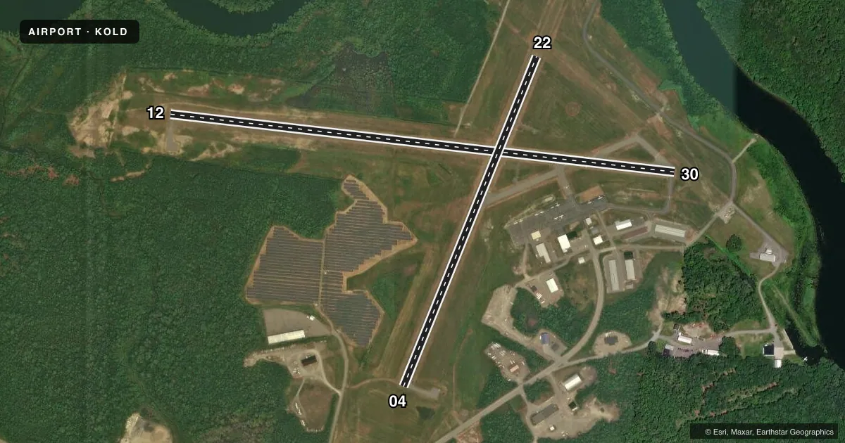
| 12/30 | 82° / 262° | 4,001 ft | ASPH | Standard L |
| 04/22 | 7° / 187° | 2,802 ft | ASPH | Standard L |
Runway end performance
| End | TORA | TODA | ASDA | LDA | VGSI | Approach lights | Obstruction |
|---|---|---|---|---|---|---|---|
| 30 | — | — | — | — | PAPI 4-box left(4°) | — | — |
| 22 | — | — | — | — | PAPI 4-box left(4°) | — | — |
Declared distances in feet. TORA = takeoff run available, TODA = takeoff distance, ASDA = accelerate-stop, LDA = landing distance.
Airport sketch
Runways drawn to scale from FAA survey coordinates, rendered over satellite imagery. Not for navigation.
Approaches & charts
Services on the field
Fuel grades, oxygen, maintenance, ramp storage and lighting — as declared to the FAA by the airport operator.
Fuel & services
- Fuel
- 100LLA
- Oxygen (bulk)
- Not available
- Airframe repair
- Major
- Power plant repair
- Major
- Other services
- BCHGR,INSTR,RNTL,SURV
Ramp & ground
- Transient storage
- Tie-down
- Landing fee
- No fee published
- Customs
- Not available
- Lighting schedule
- SEE RMK
- Beacon schedule
- SS-SR
- Beacon
- White / Green (civil land)(WG)
- Wind indicator
- Lighted
Fuel & FBOs
Cheapest 100LL and Jet A on the field and nearby. Always confirm with the FBO before taxi.
Airport notes
Surface conditions, obstructions, local procedures, lighting outages and other notes published with each FAA cycle.
General notes
- WATERFOWL, TURKEY & DEER ON & INVOF ARPT.
- FBO CLSD SUN.
- FOR CD CTC BANGOR APCH AT 207-561-2500 EXTN 1.
Lighting notes
- ACTVT REIL RWY 04; PAPI RWY 22 & 30; MIRL RWY 04/22 & 12/30 - CTAF.
Fuel notes
- 100LL24 HR FUEL WITH CREDIT CARD.
- ASELF SVC FUEL 24 HRS WITH CREDIT CARD.
Approach & departure obstructions
- 1235:1 TO DTHR.
Other notes
- EXISTED PRIOR TO 1959.
- OWNERALTN CTC: BILL MAYO, CITY MGR 207-827-3965-EXT 201.
VFR map & nearby airports
VFR sectional. Tap any ICAO chip to open that airport.
Key facts · KOLD
Answer card- ICAO
- KOLD
- Name
- DEWITT FLD/OLD TOWN MUNI
- Location
- OLD TOWN, MAINE
- Elevation
- 126.5 ft MSL
- Traffic pattern altitude
- 1,126.5 ft MSL (1,000 AGL)
- Control tower
- Non-towered (use CTAF)
- Total runways
- 2
- Longest runway
- 12/30 · 4,001 ft
- Published ILS approaches
- 0
- Published frequencies
- 4
- Magnetic variation
- 15°
- Current flight rules
- VFR
- Current wind
- 000° at 0 kt
- Favored runway now
- –
DeWitt Fld/Old Town Muni is in Old Town, Maine. Field elevation is 126.5 ft MSL. The airport has two asphalt runways. The longest is runway 12/30 at 4,001 ft. There is no control tower. Traffic pattern altitude is not published, so use 1,000 ft AGL for light piston unless the current Chart Supplement says otherwise.
No ILS approaches are published here. CTAF and UNICOM are both 122.8. Bangor Approach handles approach and departure services on 118.925 and 239.3. The on-field FBO is Old Town Municipal Airport. It carries 100LL and Jet A. Self-serve fuel is available 24 hours with a credit card. The FBO is closed on Sunday.
A few published remarks matter for planning. Runway lights on 04/22 and 12/30 are medium intensity and are controlled by CTAF. Runway end identifier lights are on runway 04. Precision approach path indicators are on runways 22 and 30. There is also an obstacle clearance slope note to the displaced threshold on runway 12. Wildlife is part of the picture here. Waterfowl, turkey and deer are reported on and near the airport. If you need clearance delivery, Bangor Approach is the published contact. For a first visit, keep the lighting setup and wildlife in mind, especially at night or during low-visibility operations.