METAR & TAF KLRG
KLRG does not publish a METAR.
Showing the nearest reporting station: KMLT (MILLINOCKET MUNI) · 18.3 NM away. Conditions at KLRG may differ.
METAR · KMLT
Observed 14:53Z
KMLT 271453Z AUTO 02003KT 10SM CLR 24/12 A2986 RMK AO2 SLP113 T02390117 58008
- Wind
- 020° @ 3 kt
- Visibility
- 10 SM
- Temp / Dew
- 24°C / 12°C
- Altimeter
- 29.86 inHg
- Clouds
- CLR
- Density alt
- 1,412 ft
- Ceiling
- Unlimited
- Rules
- VFR
Airport info & contacts
Manager on record, flight service, ARTCC, attendance schedule and pattern altitude — published by the FAA and refreshed every 28 days.
Location
- From city
- 2 NM SW
- VFR sectional
- HALIFAX
- ARTCC
- ZBW · BOSTON
- NOTAM facility
- BGR (NOTAM-D)
Airport manager
- Name
- STEW JACOBS
- Phone
- 207-403-0524
- Address
- 29 MAIN ST, LINCOLN ME 04457
Flight service · Hours
- FSS BGR
- BANGOR1-800-WX-BRIEF
- Attendance
- Unattended
Frequencies
Tap any row to copy the frequency to your clipboard.
Runways & pattern
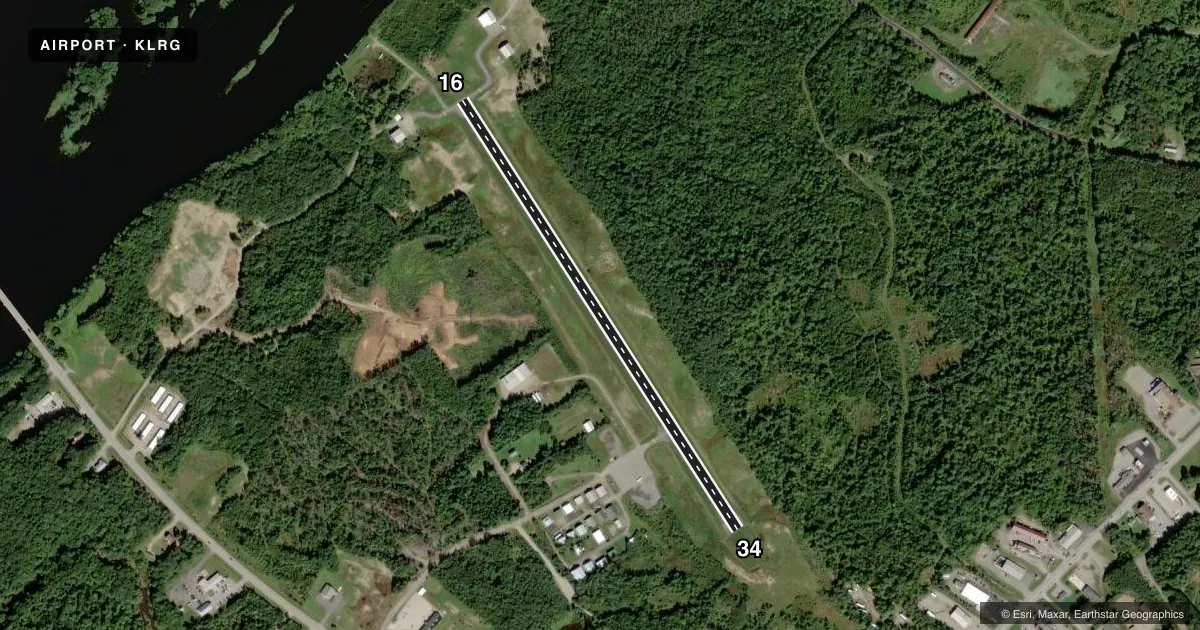
Full pagePattern entry · RWY 34
LEFT TRAFFICAirport sketch
Runways drawn to scale from FAA survey coordinates, rendered over satellite imagery. Not for navigation.
Approaches & charts
Services on the field
Fuel grades, oxygen, maintenance, ramp storage and lighting — as declared to the FAA by the airport operator.
Fuel & services
- Fuel
- 100LL
- Oxygen (bottled)
- Not available
- Oxygen (bulk)
- Not available
- Airframe repair
- Not available
- Power plant repair
- Not available
Ramp & ground
- Transient storage
- Tie-down
- Hangar
- Landing fee
- No fee published
- Customs
- Not available
- Lighting schedule
- SEE RMK
- Beacon schedule
- SS-SR
- Beacon
- White / Green (civil land)(WG)
- Wind indicator
- Yes
- Segmented circle
- Yes
Fuel & FBOs
Cheapest 100LL and Jet A on the field and nearby. Always confirm with the FBO before taxi.
Airport notes
Surface conditions, obstructions, local procedures, lighting outages and other notes published with each FAA cycle.
General notes
- 40 FT BRIDGE AT S END WATER LDG AREA.
- WILDLIFE ON & INVOF ARPT.
- RWY 6W-24W FOLLOW BUOYS UNDER BRIDGE DURING LOW WATER IN SUMMER.
- FOR CD CTC BOSTON ARTCC AT 603-879-6859.
Lighting notes
- ACTVT REIL RWY 16 & 34; MIRL RWY 16/34 - CTAF.
Fuel notes
- 100LL24 HR FUEL WITH MAJOR CREDIT CARD.
Other notes
- VFR ONLY.
- AVBL O/R.
- MANAGERALTN NR 207-290-7174, DENNIS BULLEN.
VFR map & nearby airports
VFR sectional. Tap any ICAO chip to open that airport.
Key facts · KLRG
Answer card- ICAO
- KLRG
- Name
- LINCOLN RGNL
- Location
- LINCOLN, MAINE
- Elevation
- 207.9 ft MSL
- Traffic pattern altitude
- 1,207.9 ft MSL (1,000 AGL)
- Control tower
- Non-towered (use CTAF)
- Total runways
- 1
- Longest runway
- 16/34 · 2,805 ft
- Published ILS approaches
- 0
- Published frequencies
- 2
- Magnetic variation
- 19°
- Current flight rules
- VFR
- Current wind
- 020° at 3 kt
- Favored runway now
- RWY 34
Lincoln Regional Airport sits in Lincoln, Maine. Field elevation is 207.9 ft MSL. The airport has one runway, 16/34, at 2,805 ft. There is no control tower. CTAF and UNICOM are both 122.8. No ILS approaches are published here. The published pattern altitude is not listed, so use the standard 1,000 ft AGL for light piston traffic unless the current Chart Supplement says otherwise.
This is a VFR-only field. The runway has medium intensity lighting on 16 and 34. REIL is also available on those runway ends. The airport remarks also note wildlife on and near the field. Keep a close scan on taxi, takeoff and landing. If you are planning the water landing area, watch the bridge clearance note and follow the buoys under the bridge during low water in summer.
Lincoln Regional Airport has one on-field FBO. Lincoln Regional Airport carries AVGAS 100LL. 24-hour fuel is available with a major credit card. Overnight ramp parking is also available. For clearance delivery, contact Boston Air Route Traffic Control Center. If you are new to the field, expect a small non-towered airport with local traffic on 122.8. Plan your arrival with the current Chart Supplement and the airport operator if you need anything beyond the published basics.