METAR & TAF KMLT
Current METAR
Observed 15:53Z
KMLT 271553Z AUTO 00000KT 10SM CLR 26/09 A2984 RMK AO2 SLP107 T02560094
- Wind
- 000° @ 0 kt
- Visibility
- 10 SM
- Temp / Dew
- 26°C / 9°C
- Altimeter
- 29.84 inHg
- Clouds
- CLR
- Density alt
- 1,925 ft
- Ceiling
- Unlimited
- Rules
- VFR
Airport info & contacts
Manager on record, flight service, ARTCC, attendance schedule and pattern altitude — published by the FAA and refreshed every 28 days.
Location
- From city
- 1 NM SE
- VFR sectional
- HALIFAX
- ARTCC
- ZBW · BOSTON
- NOTAM facility
- MLT (NOTAM-D)
Airport manager
- Name
- JEFF CAMPBELL
- Phone
- 207-723-6649
- Address
- MILLINOCKET MUNICIPAL ARPT, 271 MEDWAY ROAD, MILLINOCKET ME 04462
Flight service · Hours
- FSS BGR
- BANGOR1-800-WX-BRIEF
- Attendance
- MAY-NOV · MON-FRI · 0800-1600
- DEC-APR · MON-FRI · 0800-1600
- MAY-NOV · SAT-SUN · 0800-1600
- DEC-APR · SAT-SUN · Unattended
Frequencies
Tap any row to copy the frequency to your clipboard.
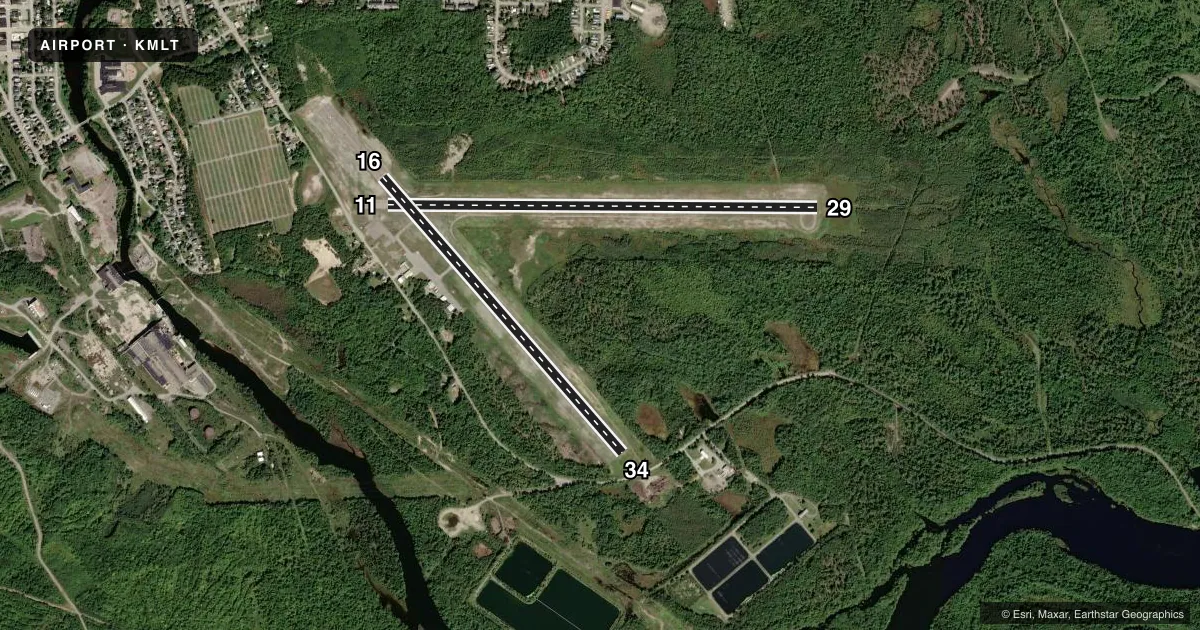
Runways & pattern
Full pagePattern entry · RWY 11
LEFT TRAFFIC| Runway | Heading (°M) | Length | Surface | Traffic |
|---|---|---|---|---|
| 11/29 | 73° / 253° | 4,713 ft | ASPH | Standard L |
| 16/34 | 122° / 302° | 4,000 ft | ASPH | Standard L |
Runway end performance
| End | TORA | TODA | ASDA | LDA | VGSI | Approach lights | Obstruction |
|---|---|---|---|---|---|---|---|
| 11 | — | — | — | — | — | — | 27', bldg, 465' from thr, 240' R of cntrln, slope 9 |
| 29 | — | — | — | — | VASI 4-box right(3°) | — | — |
| 16 | — | — | — | — | — | — | 51', trees, 1180' from thr, 45' R of cntrln, slope 19 |
| 34 | — | — | — | — | — | — | 15', road, 255' from thr, 130' R of cntrln, slope 3 |
Declared distances in feet. TORA = takeoff run available, TODA = takeoff distance, ASDA = accelerate-stop, LDA = landing distance.
Airport sketch
Runways drawn to scale from FAA survey coordinates, rendered over satellite imagery. Not for navigation.
Approaches & charts
ILS · 1
Services on the field
Fuel grades, oxygen, maintenance, ramp storage and lighting — as declared to the FAA by the airport operator.
Fuel & services
- Fuel
- 100LLA
- Oxygen (bottled)
- Not available
- Oxygen (bulk)
- Not available
- Airframe repair
- Not available
- Power plant repair
- Not available
- Other services
- INSTR,PAJA
Ramp & ground
- Transient storage
- Tie-down
- Hangar
- Landing fee
- No fee published
- Customs
- Not available
- Lighting schedule
- SEE RMK
- Beacon schedule
- SS-SR
- Beacon
- White / Green (civil land)(WG)
- Wind indicator
- Lighted
- Segmented circle
- No
Fuel & FBOs
Cheapest 100LL and Jet A on the field and nearby. Always confirm with the FBO before taxi.
Airport notes
Surface conditions, obstructions, local procedures, lighting outages and other notes published with each FAA cycle.
General notes
- WILDLIFE ON AND INVOF ARPT.
- +782 FT MSL COM/AIR QLTY MNT TWR LCTD APRXLY 5200 FT FM THR OF RWY 11 AT 247 DEGS.
- FOR CD IF UNA TO CTC ON FSS FREQ, CTC BOSTON ARTCC AT 603-879-6859 .
Lighting notes
- ACTVT REIL RWY 29; VASI RWY 29; MIRL RWY 11/29 - CTAF.
Fuel notes
- 100LLFUEL AVBL 24 HRS WITH CREDIT CARD. JET A AVBL AFT HRS 207-723-4375 OR 207-723-6649.
Approach & departure obstructions
- 298 FT BRUSH, 30-110 FT FM THR, 130-250 FT L OF CNTRLN.
- 11FADED.
- 16FADED.
- 29FADED.
- 34FADED.
Other notes
- EXISTED PRIOR TO 1959.
- CALL 207-723-6649 FOR AVBL.
- PAJAPAJA TO 10500 FT 0700 - SS DLY.
VFR map & nearby airports
VFR sectional. Tap any ICAO chip to open that airport.
Key facts · KMLT
Answer card- ICAO
- KMLT
- Name
- MILLINOCKET MUNI
- Location
- MILLINOCKET, MAINE
- Elevation
- 408.1 ft MSL
- Traffic pattern altitude
- 1,408.1 ft MSL (1,000 AGL)
- Control tower
- Non-towered (use CTAF)
- Total runways
- 2
- Longest runway
- 11/29 · 4,713 ft
- Published ILS approaches
- 1
- Published frequencies
- 2
- Magnetic variation
- 17°
- Current flight rules
- VFR
- Current wind
- 000° at 0 kt
- Favored runway now
- –
Millinocket Muni is in Millinocket, Maine. The field elevation is 408.1 ft MSL. It has two asphalt runways. The longest is runway 11/29 at 4,713 ft. There is no control tower. CTAF and UNICOM are both 122.8.
Runway 29 has an ILS approach. Runway 29 also has runway end identifier lights, a VASI and medium intensity runway lights. Runways 11 and 29 are the better lit ends for night work. Runway markings are faded on 11, 29, 16 and 34, so brief your taxi and landing plan before you get there. The published pattern altitude is not listed. Use 1,000 ft AGL unless the current Chart Supplement says otherwise.
Millinocket Municipal Airport is on the field. It carries 100LL, Jet A and Jet A Prist. 100LL is available 24 hours with credit card. Jet A is available after hours by phone. Wildlife is reported on and near the airport, so keep your scan active on taxi and final. There is also a communications and air quality tower near the field. If you need clearance delivery and cannot raise flight service, Boston ARTCC is the published backup contact. This is an uncontrolled airport with a published prior permission note for operations to 10,500 ft from 0700 to sunset daily, so verify the current Chart Supplement before you go.