METAR & TAF 52B
52B does not publish a METAR.
Showing the nearest reporting station: KMLT (MILLINOCKET MUNI) · 40.0 NM away. Conditions at 52B may differ.
METAR · KMLT
Observed 12:53Z
KMLT 271253Z AUTO 00000KT 10SM CLR 19/12 A2988 RMK AO2 SLP122 T01890122
- Wind
- 000° @ 0 kt
- Visibility
- 10 SM
- Temp / Dew
- 19°C / 12°C
- Altimeter
- 29.88 inHg
- Clouds
- CLR
- Density alt
- 1,804 ft
- Ceiling
- Unlimited
- Rules
- VFR
Airport info & contacts
Manager on record, flight service, ARTCC, attendance schedule and pattern altitude — published by the FAA and refreshed every 28 days.
Location
- From city
- 0 NM N
- VFR sectional
- MONTREAL
- ARTCC
- ZBW · BOSTON
- NOTAM facility
- BGR (NOTAM-D)
Airport manager
- Name
- TELFORD ALLEN
- Phone
- 207-299-4522
- Address
- 60 MAY STREET, BANGOR ME 04401
Flight service · Hours
- FSS BGR
- BANGOR1-800-WX-BRIEF
- Attendance
- Unattended
Frequencies
Tap any row to copy the frequency to your clipboard.
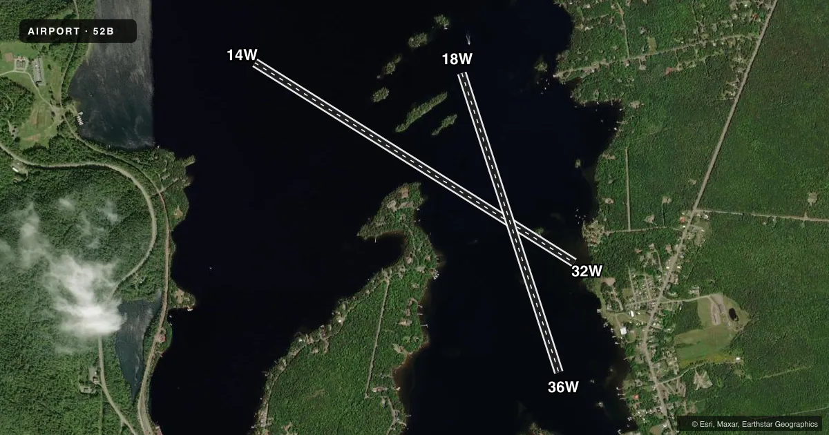
Runways & pattern
Full pagePattern entry · RWY 14W
LEFT TRAFFICAirport sketch
Runways drawn to scale from FAA survey coordinates, rendered over satellite imagery. Not for navigation.
Approaches & charts
Services on the field
Fuel grades, oxygen, maintenance, ramp storage and lighting — as declared to the FAA by the airport operator.
Fuel & services
- Fuel
- Not available
- Oxygen (bottled)
- Not available
- Oxygen (bulk)
- Not available
Ramp & ground
- Transient storage
- Not published
- Segmented circle
- No
Fuel & FBOs
Cheapest 100LL and Jet A on the field and nearby. Always confirm with the FBO before taxi.
Airport notes
Surface conditions, obstructions, local procedures, lighting outages and other notes published with each FAA cycle.
General notes
- FOR CD CTC BOSTON ARTCC AT 603-879-6859.
- BE ALERT: NEARBY 21M CURRIER'S SPB (1.1 MI WEST) UTILIZE SAME CTAF 122.9. MNT 3B1 CTAF 122.8 IF ABLE FOR LCL TFC.
- COLD TEMPERATURE AIRPORT. ALTITUDE CORRECTION REQUIRED AT OR BELOW -21C.
Other notes
- EXISTED PRIOR TO 1959.
- DOCK - BRING OWN ROPES TO SECURE ACFT.
VFR map & nearby airports
VFR sectional. Tap any ICAO chip to open that airport.
Key facts · 52B
Answer card- ICAO
- 52B
- Name
- MOOSEHEAD AERO MARINE
- Location
- GREENVILLE, MAINE
- Elevation
- 1,028 ft MSL
- Traffic pattern altitude
- 2,028 ft MSL (1,000 AGL)
- Control tower
- Non-towered (use CTAF)
- Total runways
- 2
- Longest runway
- 14W/32W · 6,000 ft
- Published ILS approaches
- 0
- Published frequencies
- 1
- Magnetic variation
- 18°
- Current flight rules
- VFR
- Current wind
- 000° at 0 kt
- Favored runway now
- –
Moosehead Aero Marine sits in Greenville, Maine. The field elevation is 1,028 ft MSL. It has two water runways. The longest is 14W/32W at 6,000 ft. 18W/36W is 5,000 ft. There is no control tower. CTAF is 122.9. No ILS approaches are published.
Pattern altitude is not published. Use the standard 1,000 ft AGL for light piston operations unless the current Chart Supplement says otherwise. That puts the pattern at about 2,028 ft MSL based on the field elevation, but verify before you fly. The airport is in a remote part of Maine. Density altitude is usually not the main issue here. Cold weather can be. This is a cold temperature airport. Altitude correction is required at or below minus 21 degrees Celsius.
There are no on-field FBOs listed. Plan on self-sufficiency for arrival planning. The Chart Supplement notes a dock is available. Bring your own ropes to secure the aircraft. Boston ARTCC handles clearance delivery. Nearby 21M Currier's Seaplane Base uses the same CTAF, so listen carefully on 122.9 and keep the traffic picture clean. If you can use 3B1 CTAF 122.8 for local traffic, that helps separate calls.