METAR & TAF 59B
59B does not publish a METAR.
Showing the nearest reporting station: CYSC (SHERBROOKE) · 61.8 NM away. Conditions at 59B may differ.
METAR · CYSC
Observed 09:00Z
CYSC 270900Z AUTO 12003KT 9SM FEW110 15/14 A2982 RMK SLP098 DENSITY ALT 1100FT
- Wind
- 120° @ 3 kt
- Visibility
- 9 SM
- Temp / Dew
- 15°C / 14°C
- Altimeter
- 29.82 inHg
- Clouds
- FEW
- Density alt
- 1,585 ft
- Ceiling
- Unlimited
- Rules
- VFR
Airport info & contacts
Manager on record, flight service, ARTCC, attendance schedule and pattern altitude — published by the FAA and refreshed every 28 days.
Location
- From city
- 1 NM W
- VFR sectional
- MONTREAL
- ARTCC
- ZBW · BOSTON
- NOTAM facility
- BGR (NOTAM-D)
Airport manager
- Name
- KIRSTIE HALE
- Phone
- 207-668-2111
- Address
- TOWN OFFICE, 569 MAIN ST, JACKMAN ME 04945
Flight service · Hours
- FSS BGR
- BANGOR1-800-WX-BRIEF
- Attendance
- Unattended
Frequencies
Tap any row to copy the frequency to your clipboard.
Runways & pattern
Full pagePattern entry · RWY 13
LEFT TRAFFICRunway end performance
| End | TORA | TODA | ASDA | LDA | VGSI | Approach lights | Obstruction |
|---|---|---|---|---|---|---|---|
| 13 | — | — | — | — | — | — | 12', tree, 221' from thr, 179' R of cntrln, slope 1 |
| 31 | — | — | — | — | — | — | 11', tree, 208' from thr, 115' R of cntrln, slope 1 |
Declared distances in feet. TORA = takeoff run available, TODA = takeoff distance, ASDA = accelerate-stop, LDA = landing distance.
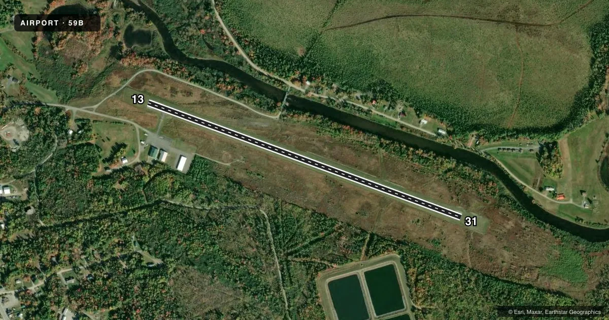
Airport sketch
Runways drawn to scale from FAA survey coordinates, rendered over satellite imagery. Not for navigation.
Approaches & charts
Services on the field
Fuel grades, oxygen, maintenance, ramp storage and lighting — as declared to the FAA by the airport operator.
Fuel & services
- Fuel
- 100LL
- Oxygen (bottled)
- Not available
- Oxygen (bulk)
- Not available
- Airframe repair
- Not available
- Power plant repair
- Not available
Ramp & ground
- Transient storage
- Tie-down
- Hangar
- Landing fee
- No fee published
- Customs
- Not available
- Lighting schedule
- SEE RMK
- Beacon schedule
- SS-SR
- Beacon
- White / Green (civil land)(WG)
- Wind indicator
- Lighted
- Segmented circle
- Yes
Fuel & FBOs
Cheapest 100LL and Jet A on the field and nearby. Always confirm with the FBO before taxi.
Airport notes
Surface conditions, obstructions, local procedures, lighting outages and other notes published with each FAA cycle.
General notes
- GEESE, DEER & MOOSE ON & INVOF ARPT.
- ARPT PHONE AVBL FOR LOCAL CALLS ONLY.
- FOR CD CTC BOSTON ARTCC AT 603-879-6859.
- COLD TEMPERATURE AIRPORT. ALTITUDE CORRECTION REQUIRED AT OR BELOW -23C.
Lighting notes
- ACTVT REIL RWY 31; MIRL RWY 13/31 - CTAF.
Fuel notes
- 100LLFUEL AVBL 24 HRS WITH MAJOR CREDIT CARD.
Approach & departure obstructions
- 13+4 FT GRASS 50-200 FT FM THR, 80 FT R OF CNTRLN.
- 31+12 FT TREE AND BRUSH 0-20 FT FM THR, 120 FT R OF CNTRLN; +4 FT TREE 10 FT FM THR, 150 FT L OF CNTRLN.
Other notes
- EXISTED PRIOR TO 1959.
- MNTN 122.9 WI VCNTY OF ARPT. 3 CLICKS ADZY & WX.
- CALL 207-668-2111 FOR AVBL.
VFR map & nearby airports
VFR sectional. Tap any ICAO chip to open that airport.
Key facts · 59B
Answer card- ICAO
- 59B
- Name
- NEWTON FLD
- Location
- JACKMAN, MAINE
- Elevation
- 1,177.9 ft MSL
- Traffic pattern altitude
- 2,177.9 ft MSL (1,000 AGL)
- Control tower
- Non-towered (use CTAF)
- Total runways
- 1
- Longest runway
- 13/31 · 3,601 ft
- Published ILS approaches
- 0
- Published frequencies
- 1
- Magnetic variation
- 16°
- Current flight rules
- VFR
- Current wind
- 120° at 3 kt
- Favored runway now
- RWY 13
Newton Fld (59B) sits in Jackman, Maine at 1,177.9 ft MSL. It has one runway, 13/31, which is 3,601 ft long and paved with asphalt. There is no control tower. CTAF is 122.9. No ILS approaches are published here, so plan with that in mind if the weather is marginal.
The published pattern altitude is not listed. Use the standard 1,000 ft AGL for light piston traffic unless the current FAA Chart Supplement says otherwise. Newton Field is on the field. It carries 100LL. The fuel is available 24 hours with a major credit card. Call 207-668-2111 for availability if you want current status before you go.
A few operational items matter here. Runway 31 has threshold lights and runway end identifier lights. Medium intensity runway lights are on runway 13/31 and are controlled by CTAF. There are published obstructions near both ends, including trees and brush near runway 31 and grass near runway 13. Wildlife is also a factor. Geese, deer and moose are reported on and near the airport. This is a cold temperature airport too. Altitude correction is required at or below minus 23 degrees Celsius. For clearance delivery, contact Boston ARTCC at 603-879-6859.