METAR & TAF B21
B21 does not publish a METAR.
Showing the nearest reporting station: KWVL (WATERVILLE RGNL) · 40.4 NM away. Conditions at B21 may differ.
METAR · KWVL
Observed 17:15Z
KWVL 231715Z AUTO 36008KT 10SM BKN013 BKN019 OVC029 19/16 A2982 RMK AO2
- Wind
- 360° @ 8 kt
- Visibility
- 10 SM
- Temp / Dew
- 19°C / 16°C
- Altimeter
- 29.82 inHg
- Clouds
- OVC
- Density alt
- 1,695 ft
- Ceiling
- 1,300 ft AGL
- Rules
- MVFR
Airport info & contacts
Manager on record, flight service, ARTCC, attendance schedule and pattern altitude — published by the FAA and refreshed every 28 days.
Location
- From city
- 1 NM N
- VFR sectional
- MONTREAL
- Pattern altitude
- 2,000 ft AGL · 2,880 ft MSL
- ARTCC
- ZBW · BOSTON
- NOTAM facility
- BGR (NOTAM-D)
Airport manager
- Name
- TOM WALLACE
- Phone
- 207-350-1415
- Address
- 1001 CARRIAGE RD, CARRABASSETT VALLEY ME 04947
Flight service · Hours
- FSS BGR
- BANGOR1-800-WX-BRIEF
- Attendance
- Unattended
Frequencies
Tap any row to copy the frequency to your clipboard.
Runways & pattern
Full pagePattern entry · RWY 35
LEFT TRAFFICRunway end performance
| End | TORA | TODA | ASDA | LDA | VGSI | Approach lights | Obstruction |
|---|---|---|---|---|---|---|---|
| 17 | — | — | — | — | — | — | 10', road, 200' from thr, 85' R of cntrln, slope 0 |
| 35 | — | — | — | — | — | — | 53', bldg, 316' from thr, 160' R of cntrln, slope 2 |
Declared distances in feet. TORA = takeoff run available, TODA = takeoff distance, ASDA = accelerate-stop, LDA = landing distance.
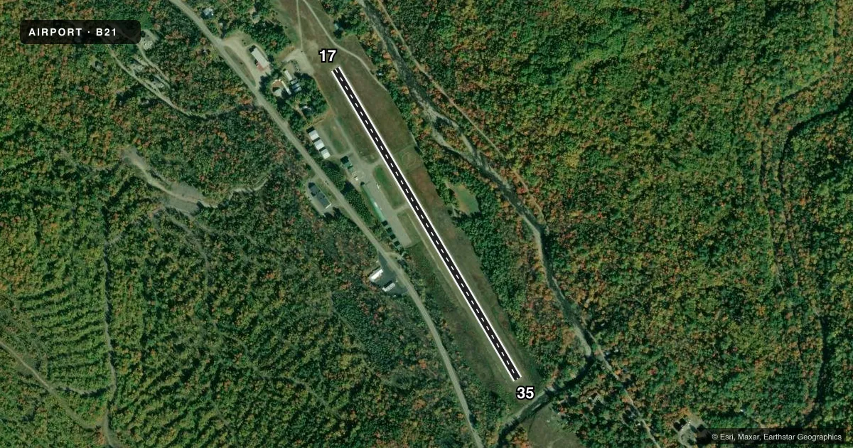
Airport sketch
Runways drawn to scale from FAA survey coordinates, rendered over satellite imagery. Not for navigation.
Approaches & charts
Services on the field
Fuel grades, oxygen, maintenance, ramp storage and lighting — as declared to the FAA by the airport operator.
Fuel & services
- Fuel
- 100LLMOGAS
- Oxygen (bottled)
- Not available
- Oxygen (bulk)
- Not available
- Airframe repair
- Not available
- Power plant repair
- Not available
Ramp & ground
- Transient storage
- Tie-down
- Landing fee
- No fee published
- Customs
- Not available
- Wind indicator
- Yes
- Segmented circle
- Yes
Fuel & FBOs
Cheapest 100LL and Jet A on the field and nearby. Always confirm with the FBO before taxi.
Airport notes
Surface conditions, obstructions, local procedures, lighting outages and other notes published with each FAA cycle.
General notes
- HIGH TRRN 4237 FT MSL NORTH/EAST/WEST OF ARPT.
- CALL 207-350-1415 TO CK ARPT CONDS.
- DEER, MOOSE & TURKEY ON & INVOF ARPT.
- FOR CD CTC BOSTON ARTCC AT 603-879-6859.
Approach & departure obstructions
- 17+10 FT ROADWAY 100-200 FT FM THR, 85-125 FT L OF CNTRLN.
Other notes
- VFR OPS ONLY.
- BRING OWN TIE DOWN ROPES OR CHAINS.
- MANAGERADDNL CTC: TOM WALLACE AT TLWCFII@YAHOO.COM.
VFR map & nearby airports
VFR sectional. Tap any ICAO chip to open that airport.
Key facts · B21
Answer card- ICAO
- B21
- Name
- SUGARLOAF RGNL
- Location
- CARRABASSETT, MAINE
- Elevation
- 880 ft MSL
- Traffic pattern altitude
- 2,880 ft MSL (2,000 AGL)
- Control tower
- Non-towered (use CTAF)
- Total runways
- 1
- Longest runway
- 17/35 · 2,797 ft
- Published ILS approaches
- 0
- Published frequencies
- 2
- Magnetic variation
- 17°
- Current flight rules
- MVFR
- Current wind
- 360° at 8 kt
- Favored runway now
- RWY 35
Sugarloaf Rgnl (B21) sits in Carrabassett, Maine. Field elevation is 880 ft MSL. The airport has one runway, 17/35, at 2,797 ft asphalt. The field is non-towered. CTAF and UNICOM are both 122.8. No ILS approaches are published here. Pattern altitude is 2,000 ft AGL, which is 2,880 ft MSL.
This is a VFR-only field. Plan accordingly. High terrain rises to 4,237 ft MSL north, east and west of the airport. That matters for departure planning. It also matters for staying ahead of weather. There is a roadway near the threshold area of runway 17. It is offset left of centerline. Deer, moose and turkey are reported on and near the airport. Use extra caution on taxi, takeoff and landing.
Sugarloaf Regional Airport is the on-field FBO. It carries 100LL and MOGAS. Bring your own tie-down ropes or chains. For current airport conditions, the published remarks say to call ahead before you go. If you need clearance delivery, contact Boston Center by phone. First-time visitors should review the current Chart Supplement before arrival. Verify local conditions with the airport operator or the FBO directly by phone.