METAR & TAF M57
M57 does not publish a METAR.
Showing the nearest reporting station: KBML (BERLIN RGNL) · 31.5 NM away. Conditions at M57 may differ.
METAR · KBML
Observed 04:52Z
KBML 270452Z AUTO 00000KT 10SM CLR 12/11 A2988 RMK AO2 SLP114 T01170106 402830094 $
- Wind
- 000° @ 0 kt
- Visibility
- 10 SM
- Temp / Dew
- 12°C / 11°C
- Altimeter
- 29.88 inHg
- Clouds
- CLR
- Density alt
- 1,572 ft
- Ceiling
- Unlimited
- Rules
- VFR
Airport info & contacts
Manager on record, flight service, ARTCC, attendance schedule and pattern altitude — published by the FAA and refreshed every 28 days.
Location
- From city
- 2 NM N
- VFR sectional
- MONTREAL
- ARTCC
- ZBW · BOSTON
- NOTAM facility
- BGR (NOTAM-D)
Airport manager
- Name
- KEITH DESCHAMBEAU
- Phone
- 207-252-6630
- Address
- 2640 MAIN ST, RANGELEY ME 04970
Flight service · Hours
- FSS BGR
- BANGOR1-800-WX-BRIEF
- Attendance
- MAY-OCT
Frequencies
Tap any row to copy the frequency to your clipboard.
Runways & pattern
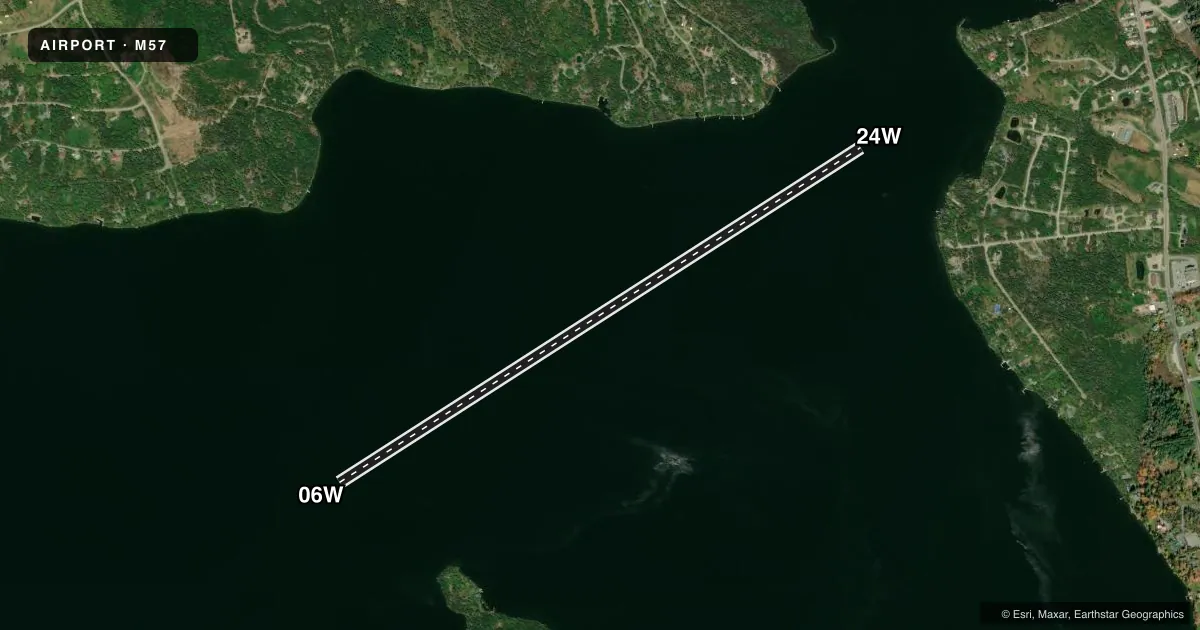
Full pagePattern entry · RWY 06W
LEFT TRAFFICAirport sketch
Runways drawn to scale from FAA survey coordinates, rendered over satellite imagery. Not for navigation.
Approaches & charts
Services on the field
Fuel grades, oxygen, maintenance, ramp storage and lighting — as declared to the FAA by the airport operator.
Fuel & services
- Fuel
- 100LL
- Other services
- CHTR
Ramp & ground
- Transient storage
- Not published
- Segmented circle
- No
Fuel & FBOs
Cheapest 100LL and Jet A on the field and nearby. Always confirm with the FBO before taxi.
Airport notes
Surface conditions, obstructions, local procedures, lighting outages and other notes published with each FAA cycle.
General notes
- SGFNT BOAT ACT IN SUMMER MONTHS.
- FOR CD CTC BOSTON ARTCC AT 603-879-6859.
- COLD TEMPERATURE AIRPORT. ALTITUDE CORRECTION REQUIRED AT OR BELOW -26C.
VFR map & nearby airports
VFR sectional. Tap any ICAO chip to open that airport.
Key facts · M57
Answer card- ICAO
- M57
- Name
- RANGELEY LAKE
- Location
- RANGELEY, MAINE
- Elevation
- 1,518 ft MSL
- Traffic pattern altitude
- 2,518 ft MSL (1,000 AGL)
- Control tower
- Non-towered (use CTAF)
- Total runways
- 1
- Longest runway
- 06W/24W · 7,000 ft
- Published ILS approaches
- 0
- Published frequencies
- 1
- Magnetic variation
- 18°
- Current flight rules
- VFR
- Current wind
- 000° at 0 kt
- Favored runway now
- –
Rangeley Lake (M57) sits in Rangeley, Maine. The field elevation is 1,518 ft MSL. It has one runway. Runway 06W/24W is a 7,000 ft water runway with magnetic headings of 57° and 237°. There is no control tower. CTAF is 122.9.
No ILS approaches are published here. The pattern altitude is not published, so use the standard 1,000 ft AGL for light piston operations unless the current Chart Supplement says otherwise. Acadian Seaplanes is on the field. Fuel grades are not reported, so call them at (207) 864-5307 before you go if fuel planning matters.
Two operational items stand out. Summer boat traffic can be significant on the lake. That matters for takeoff and landing planning on the waterway. This is also a cold temperature airport. Altitude correction is required at or below minus 26 degrees Celsius. For IFR clearance delivery, contact Boston ARTCC at 603-879-6859. If you need current procedures or any local restrictions, check the current FAA Chart Supplement before departure.