METAR & TAF 8B0
Current METAR
Observed 13:35Z
K8B0 271335Z AUTO 00000KT 10SM CLR 22/15 A2989 RMK AO2
- Wind
- 000° @ 0 kt
- Visibility
- 10 SM
- Temp / Dew
- 22°C / 15°C
- Altimeter
- 29.89 inHg
- Clouds
- CLR
- Density alt
- 3,135 ft
- Ceiling
- Unlimited
- Rules
- VFR
Airport info & contacts
Manager on record, flight service, ARTCC, attendance schedule and pattern altitude — published by the FAA and refreshed every 28 days.
Location
- From city
- 2 NM NW
- VFR sectional
- MONTREAL
- ARTCC
- ZBW · BOSTON
- NOTAM facility
- BGR (NOTAM-D)
Airport manager
- Name
- JOE ROACH
- Phone
- 207-864-3326
- Address
- 15 SCHOOL ST, RANGELEY ME 04970
Flight service · Hours
- FSS BGR
- BANGOR1-800-WX-BRIEF
- Attendance
- UNATTENDED
Frequencies
Tap any row to copy the frequency to your clipboard.
Runways & pattern
Full pagePattern entry · RWY 14
LEFT TRAFFICRunway end performance
| End | TORA | TODA | ASDA | LDA | VGSI | Approach lights | Obstruction |
|---|---|---|---|---|---|---|---|
| 14 | — | — | — | — | PAPI 4-box left(3°) | — | — |
| 32 | — | — | — | — | PAPI 4-box left(3°) | — | — |
Declared distances in feet. TORA = takeoff run available, TODA = takeoff distance, ASDA = accelerate-stop, LDA = landing distance.
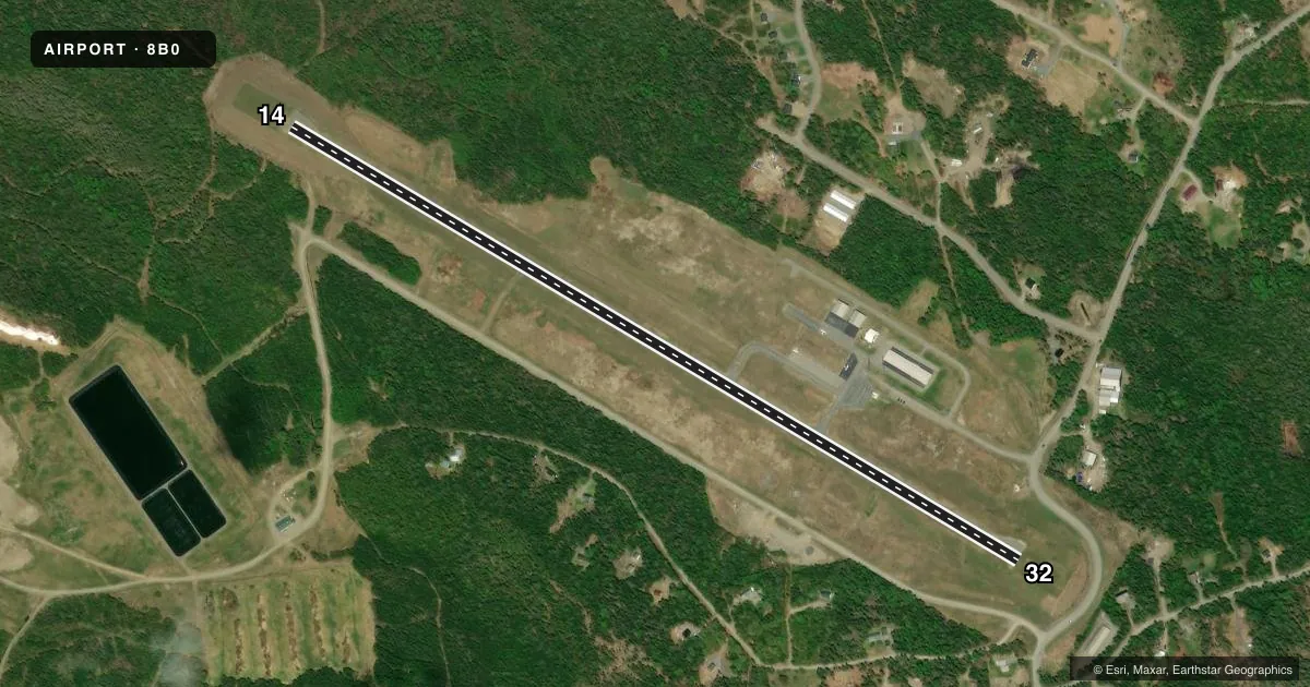
Airport sketch
Runways drawn to scale from FAA survey coordinates, rendered over satellite imagery. Not for navigation.
Approaches & charts
Services on the field
Fuel grades, oxygen, maintenance, ramp storage and lighting — as declared to the FAA by the airport operator.
Fuel & services
- Fuel
- 100LLA
- Oxygen (bottled)
- Not available
- Oxygen (bulk)
- Not available
Ramp & ground
- Transient storage
- Tie-down
- Hangar
- Landing fee
- No fee published
- Customs
- Not available
- Lighting schedule
- SEE RMK
- Beacon schedule
- SS-SR
- Beacon
- White / Green (civil land)(WG)
- Wind indicator
- Lighted
- Segmented circle
- Yes
Fuel & FBOs
Cheapest 100LL and Jet A on the field and nearby. Always confirm with the FBO before taxi.
Airport notes
Surface conditions, obstructions, local procedures, lighting outages and other notes published with each FAA cycle.
General notes
- MIGRATORY BIRDS ON & INVOF ARPT.
- MIL OPS IN AREA (F16, A-10 ACFT & HEL).
- FOR CD CTC BOSTON ARTCC AT 603-879-6859.
- COLD TEMPERATURE AIRPORT. ALTITUDE CORRECTION REQUIRED AT OR BELOW -30C.
Lighting notes
- ACTVT REIL RWY 14 & 32; PAPI RWY 14 & 32; MIRL RWY 14/32 - CTAF.
Fuel notes
- 100LLFOR FUEL CALL 207-864-5307 OR 207-252-6630.
Approach & departure obstructions
- 14+2 -3 FT GRASS & WEEDS 25-200 FT FM THR, ACRS APCH.
- 14NRS & CNTRLN FADED OR MISG.
- 32NRS & CNTRLN FADED OR MISG.
- 14UNUSBL BYD 3 NM.
Other notes
- EXISTED PRIOR TO 1959.
- BRING OWN TIE DOWN ROPES.
VFR map & nearby airports
VFR sectional. Tap any ICAO chip to open that airport.
Key facts · 8B0
Answer card- ICAO
- 8B0
- Name
- STEPHEN A BEAN MUNI
- Location
- RANGELEY, MAINE
- Elevation
- 1,821.2 ft MSL
- Traffic pattern altitude
- 2,821.2 ft MSL (1,000 AGL)
- Control tower
- Non-towered (use CTAF)
- Total runways
- 1
- Longest runway
- 14/32 · 4,299 ft
- Published ILS approaches
- 0
- Published frequencies
- 2
- Magnetic variation
- 18°
- Current flight rules
- VFR
- Current wind
- 000° at 0 kt
- Favored runway now
- –
Stephen A Bean Muni is in Rangeley, Maine. The field elevation is 1,821.2 ft MSL. It has one runway, 14/32, which is 4,299 ft long with asphalt pavement. There is no control tower. CTAF and UNICOM are both 122.8. No ILS approaches are published here.
The published pattern altitude is not listed, so use the standard 1,000 ft AGL for light piston aircraft unless the current FAA Chart Supplement says otherwise. Acadian Seaplanes is on the field. Call them at (207) 864-5307 for current fuel availability. The published remarks say 100LL can be arranged by phone. Bring your own tie down ropes.
A few operational notes matter here. Runway 14 has grass and weeds 25 to 200 feet from the threshold across the approach path. The runway 14 VASI is unusable beyond 3 NM. Runway numbers and centerline markings are faded or missing on both ends. The runway lights, REILs and PAPI are controlled by CTAF. This is a cold temperature airport, so altitude correction is required at or below minus 30 degrees Celsius. Military traffic also operates in the area, including F-16s, A-10s and helicopters. Check the current FAA Chart Supplement for any noise or curfew restrictions before flying in.