METAR & TAF KERR
KERR does not publish a METAR.
Showing the nearest reporting station: KBML (BERLIN RGNL) · 13.0 NM away. Conditions at KERR may differ.
METAR · KBML
Observed 11:08Z
KBML 271108Z AUTO 00000KT 7SM SCT001 12/11 A2988 RMK AO2 T01220111 $
- Wind
- 000° @ 0 kt
- Visibility
- 7 SM
- Temp / Dew
- 12°C / 11°C
- Altimeter
- 29.88 inHg
- Clouds
- SCT
- Density alt
- 1,237 ft
- Ceiling
- Unlimited
- Rules
- VFR
Airport info & contacts
Manager on record, flight service, ARTCC, attendance schedule and pattern altitude — published by the FAA and refreshed every 28 days.
Location
- From city
- 1 NM NW
- VFR sectional
- MONTREAL
- Pattern altitude
- 800 ft AGL · 2,048 ft MSL
- ARTCC
- ZBW · BOSTON
- NOTAM facility
- BGR (NOTAM-D)
Airport manager
- Name
- THADDEUS PRESBY
- Phone
- 603-616-8602
- Address
- 244 MAIN ST, FRANCONIA NH 03580
Flight service · Hours
- FSS BGR
- BANGOR1-800-WX-BRIEF
- Attendance
- Unattended
Frequencies
Tap any row to copy the frequency to your clipboard.
Runways & pattern
Full pagePattern entry · RWY 15
LEFT TRAFFICRunway end performance
| End | TORA | TODA | ASDA | LDA | VGSI | Approach lights | Obstruction |
|---|---|---|---|---|---|---|---|
| 15 | — | — | — | — | — | — | 75', trees, 42' from thr, 62' R of cntrln, slope 0 |
| 33 | — | — | — | — | — | — | 44', trees, 112' from thr, 91' R of cntrln, slope 2 |
Declared distances in feet. TORA = takeoff run available, TODA = takeoff distance, ASDA = accelerate-stop, LDA = landing distance.
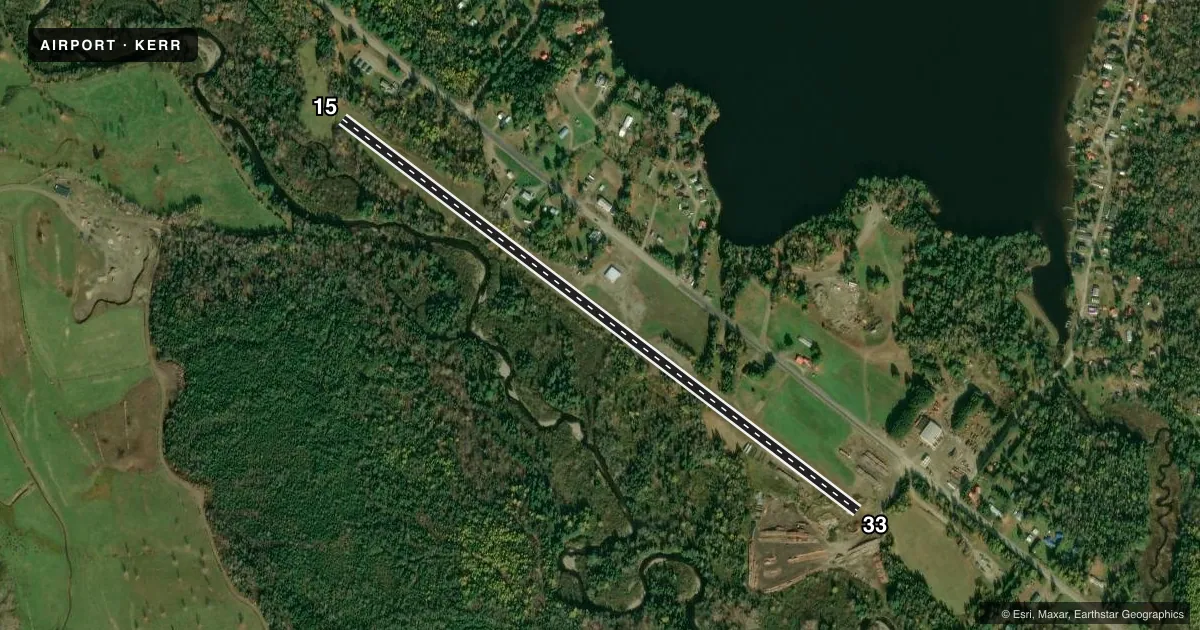
Airport sketch
Runways drawn to scale from FAA survey coordinates, rendered over satellite imagery. Not for navigation.
Approaches & charts
Services on the field
Fuel grades, oxygen, maintenance, ramp storage and lighting — as declared to the FAA by the airport operator.
Fuel & services
- Fuel
- Not available
- Oxygen (bottled)
- Not available
- Oxygen (bulk)
- Not available
- Airframe repair
- Not available
- Power plant repair
- Not available
Ramp & ground
- Transient storage
- Tie-down
- Landing fee
- No fee published
- Customs
- Not available
- Wind indicator
- Lighted
- Segmented circle
- No
Fuel & FBOs
Cheapest 100LL and Jet A on the field and nearby. Always confirm with the FBO before taxi.
Airport notes
Surface conditions, obstructions, local procedures, lighting outages and other notes published with each FAA cycle.
General notes
- FOR ARPT INFO AND CONDS, CALL 603-482-3320.
- WILDLIFE ON & INVOF ARPT.
- RGLR CONST VEHICLE TRAF ON ROADWAY AT RWY 33 END. 1:1 CLNC SLOPE.
- FOR CD CTC BOSTON ARTCC AT 603-879-6859.
Runway surface & condition
- H1ACTVT HELIPAD FLOOD LGT & LGTD WINDCONE - CTAF.
Approach & departure obstructions
- 15TREES ALG L & R EDGES OF THE RWY.
- 15CONTROLLING OBSTN EXCEEDS A 45 DEG SLP.
- 15MTRL STOCK PILES.
Other notes
- BUILT BEFORE 1959.
- 15/33RWY SOFT IN SPRING. LRG PATCHES OF GRASS ON RWY.
VFR map & nearby airports
VFR sectional. Tap any ICAO chip to open that airport.
Key facts · KERR
Answer card- ICAO
- KERR
- Name
- ERROL
- Location
- ERROL, NEW HAMPSHIRE
- Elevation
- 1,248 ft MSL
- Traffic pattern altitude
- 2,048 ft MSL (800 AGL)
- Control tower
- Non-towered (use CTAF)
- Total runways
- 1
- Longest runway
- 15/33 · 3,600 ft
- Published ILS approaches
- 0
- Published frequencies
- 2
- Magnetic variation
- 17°
- Current flight rules
- VFR
- Current wind
- 000° at 0 kt
- Favored runway now
- –
Errol Airport sits in Errol, New Hampshire. The field elevation is 1,248 ft MSL. It has one runway, 15/33, which is 3,600 ft long and gravel. There is no control tower. CTAF and UNICOM are both 122.8. No ILS approaches are published here.
Pattern altitude is 800 ft AGL, which is 2,048 ft MSL. That matters here because the field is already elevated. The published remarks also point to a few items a first-time pilot should plan around. Runway 15 has trees along both edges. There are material stockpiles near runway 15. The controlling obstruction on that end exceeds a 45 degree slope. Runway 33 has regular construction vehicle traffic on the roadway near the end. The runway is also noted as soft in spring with large patches of grass on the surface.
There are no on-field FBOs listed. For airport information and current conditions, call the airport at 603-482-3320. For clearance delivery, contact Boston ARTCC at 603-879-6859. Wildlife is reported on and near the airport. The helipad has activated flood lighting and a lighted windcone on CTAF. This is a small, non-towered field with a gravel surface, so plan your arrival and departure with the published remarks in mind and verify current conditions before you go.