METAR & TAF KBML
Current METAR
Observed 11:52Z
KBML 271152Z AUTO 00000KT 10SM CLR 15/13 A2988 RMK AO2 SLP118 T01500128 10150 20089 51007 $
- Wind
- 000° @ 0 kt
- Visibility
- 10 SM
- Temp / Dew
- 15°C / 13°C
- Altimeter
- 29.88 inHg
- Clouds
- CLR
- Density alt
- 1,490 ft
- Ceiling
- Unlimited
- Rules
- VFR
Airport info & contacts
Manager on record, flight service, ARTCC, attendance schedule and pattern altitude — published by the FAA and refreshed every 28 days.
Location
- From city
- 7 NM N
- VFR sectional
- MONTREAL
- ARTCC
- ZBW · BOSTON
- NOTAM facility
- BML (NOTAM-D)
Airport manager
- Name
- DAVID ARSENAULT
- Phone
- 603-449-2168
- Address
- 800 EAST SIDE RIVER RD., MILAN NH 03588
Flight service · Hours
- FSS BGR
- BANGOR1-800-WX-BRIEF
- Attendance
- 0800-1600
Frequencies
Tap any row to copy the frequency to your clipboard.
Runways & pattern
Full pagePattern entry · RWY 18
LEFT TRAFFICRunway end performance
| End | TORA | TODA | ASDA | LDA | VGSI | Approach lights | Obstruction |
|---|---|---|---|---|---|---|---|
| 18 | — | — | — | — | PAPI 4-box left(3.5°) | — | 17', trees, 335' from thr, 115' R of cntrln, slope 7 |
| 36 | — | — | — | — | — | — | 51', trees, 711' from thr, 151' R of cntrln, slope 10 |
Declared distances in feet. TORA = takeoff run available, TODA = takeoff distance, ASDA = accelerate-stop, LDA = landing distance.
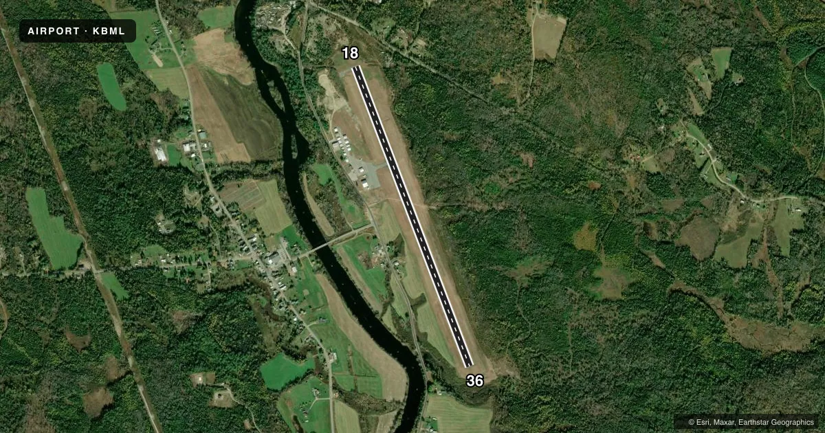
Airport sketch
Runways drawn to scale from FAA survey coordinates, rendered over satellite imagery. Not for navigation.
Approaches & charts
Services on the field
Fuel grades, oxygen, maintenance, ramp storage and lighting — as declared to the FAA by the airport operator.
Fuel & services
- Fuel
- 100LLA
- Oxygen (bottled)
- Not available
- Oxygen (bulk)
- Not available
- Airframe repair
- Minor
- Power plant repair
- Minor
Ramp & ground
- Transient storage
- Tie-down
- Landing fee
- No fee published
- Customs
- Not available
- Lighting schedule
- SEE RMK
- Beacon schedule
- SS-SR
- Beacon
- White / Green (civil land)(WG)
- Wind indicator
- Lighted
- Segmented circle
- No
Fuel & FBOs
Cheapest 100LL and Jet A on the field and nearby. Always confirm with the FBO before taxi.
Airport notes
Surface conditions, obstructions, local procedures, lighting outages and other notes published with each FAA cycle.
General notes
- OBSTN LGTS ON ANT POLES; HAZARD BCNS ON SURROUNDING HILLS.
- WILDLIFE ON & INVOF ARPT.
- COLD TEMPERATURE AIRPORT. ALTITUDE CORRECTION REQUIRED AT OR BELOW -28C.
- FOR CD IF UNA TO CTC ON FSS FREQ, CTC BOSTON ARTCC AT 603-879-6859.
- RENTAL CARS & CATERING AVBL BY REQ, CALL 603-915-0214.
Lighting notes
- ACTVT REIL RWY 18 & 36, PAPI RWY 18, HIRL RWY 18/36 - CTAF.
Fuel notes
- 100LLSELF-SERVE 100LL AVBL 24 HRS WITH CREDIT CARD SYSTEM. FOR JET A AFTER HRS CALL 603-915-0214.
Other notes
- ESTAB PRIOR 1959
- CORPORATE AND CHTR ACFT LDG FEE FOR ALL PISTON, TURBOPROP & JET ACFT. LDG FEE WAIVED WITH FUEL PURCHASE & OVNGT PRKG, CORPORATE & CHTR ACFT OVNGT PRKG FEE. CTC AMGR.
- MANAGERAMGR AFT HRS FONE 603-915-0214.
VFR map & nearby airports
VFR sectional. Tap any ICAO chip to open that airport.
Key facts · KBML
Answer card- ICAO
- KBML
- Name
- BERLIN RGNL
- Location
- BERLIN, NEW HAMPSHIRE
- Elevation
- 1,161.3 ft MSL
- Traffic pattern altitude
- 2,161.3 ft MSL (1,000 AGL)
- Control tower
- Non-towered (use CTAF)
- Total runways
- 1
- Longest runway
- 18/36 · 5,200 ft
- Published ILS approaches
- 0
- Published frequencies
- 2
- Magnetic variation
- 16°
- Current flight rules
- VFR
- Current wind
- 000° at 0 kt
- Favored runway now
- –
Berlin RGNL sits in Berlin, New Hampshire. The field elevation is 1,161.3 ft MSL. It has one runway. Runway 18/36 is 5,200 ft of asphalt, with magnetic headings 159° and 339°. There is no control tower. CTAF and UNICOM are both 122.7.
No ILS approaches are published here. Pattern altitude is not published, so use the standard 1,000 ft AGL for light piston traffic unless the current FAA Chart Supplement says otherwise. The airport is in a higher terrain area. Obstruction lights are reported on antenna poles. Hazard beacons are also reported on surrounding hills. Wildlife is also noted on and near the airport. Stay alert on taxi, takeoff and landing.
Berlin Regional Airport is the on-field FBO. It carries 100LL and Jet A Prist. Self-serve 100LL is available 24 hours with a credit card system. For Jet A after hours, call the airport number in the Chart Supplement or the airport manager. The published remarks also note runway lights, runway end identifier lights and a PAPI on runway 18. Those lights are activated by the CTAF. The airport manager can also help with rental cars, catering and after-hours questions.