METAR & TAF 8B2
8B2 does not publish a METAR.
Showing the nearest reporting station: KHIE (MOUNT WASHINGTON RGNL) · 6.2 NM away. Conditions at 8B2 may differ.
METAR · KHIE
Observed 21:52Z
KHIE 262152Z AUTO 17006KT 10SM SCT065 26/13 A2985 RMK AO2 SLP106 T02610133
- Wind
- 170° @ 6 kt
- Visibility
- 10 SM
- Temp / Dew
- 26°C / 13°C
- Altimeter
- 29.85 inHg
- Clouds
- SCT
- Density alt
- 3,216 ft
- Ceiling
- Unlimited
- Rules
- VFR
Airport info & contacts
Manager on record, flight service, ARTCC, attendance schedule and pattern altitude — published by the FAA and refreshed every 28 days.
Location
- From city
- 1 NM SW
- VFR sectional
- MONTREAL
- ARTCC
- ZBW · BOSTON
- NOTAM facility
- BGR (NOTAM-D)
Airport manager
- Name
- DR. EVAN KARPF
- Phone
- 603-325-5420
- Address
- PO BOX 97, TWIN MOUNTAIN NH 03595
Flight service · Hours
- FSS BGR
- BANGOR1-800-WX-BRIEF
- Attendance
- IREG
- NOV-MAR · Unattended
Frequencies
Tap any row to copy the frequency to your clipboard.
Runways & pattern
Full pagePattern entry · RWY 27
LEFT TRAFFICRunway end performance
| End | TORA | TODA | ASDA | LDA | VGSI | Approach lights | Obstruction |
|---|---|---|---|---|---|---|---|
| 09 | — | — | — | — | — | — | 76', trees, 275' from thr, 63' R of cntrln, slope 0 |
| 27 | — | — | — | — | — | — | 46', trees, 219' from thr, 58' R of cntrln, slope 0 |
Declared distances in feet. TORA = takeoff run available, TODA = takeoff distance, ASDA = accelerate-stop, LDA = landing distance.
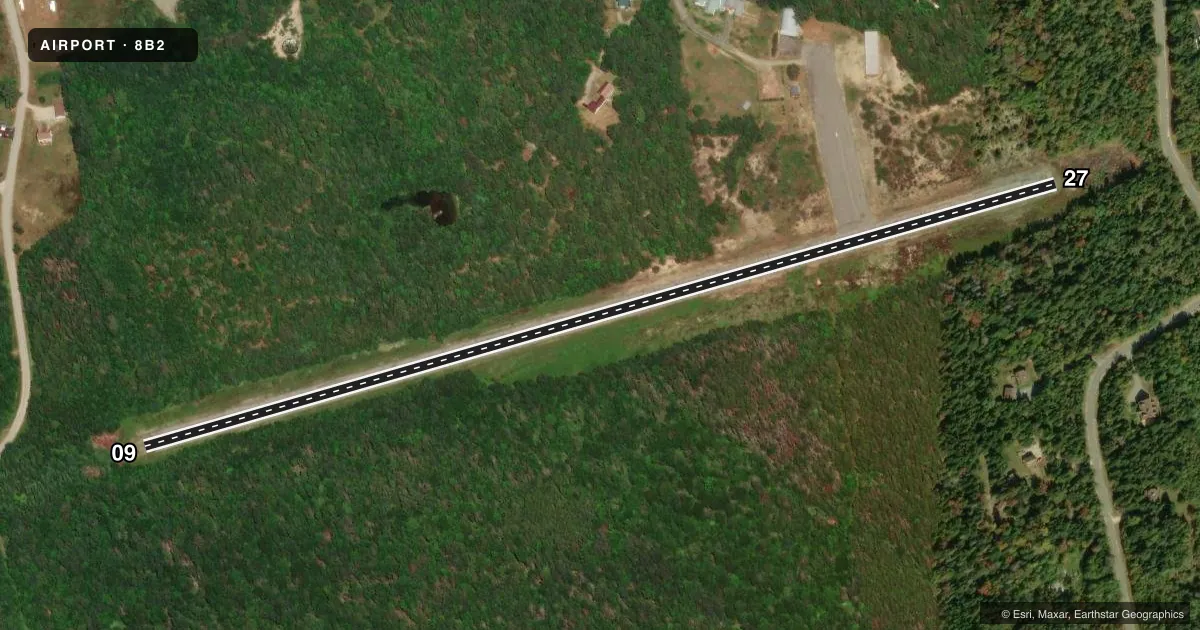
Airport sketch
Runways drawn to scale from FAA survey coordinates, rendered over satellite imagery. Not for navigation.
Approaches & charts
Services on the field
Fuel grades, oxygen, maintenance, ramp storage and lighting — as declared to the FAA by the airport operator.
Fuel & services
- Fuel
- Not available
- Oxygen (bottled)
- Not available
- Oxygen (bulk)
- Not available
Ramp & ground
- Transient storage
- Tie-down
- Hangar
- Landing fee
- No fee published
- Customs
- Not available
- Wind indicator
- Yes
- Segmented circle
- No
Fuel & FBOs
Cheapest 100LL and Jet A on the field and nearby. Always confirm with the FBO before taxi.
Airport notes
Surface conditions, obstructions, local procedures, lighting outages and other notes published with each FAA cycle.
General notes
- ACFT ARE REQSTD TO STAY ON PAVED SFCS ONLY.
- WILDLIFE ON & INVOF ARPT.
- ARPT NOT PLOWED IN WINTER. FOR INFO CALL 603-846-5505.
- FOR CD CTC BOSTON ARTCC AT 603-879-6859.
Approach & departure obstructions
- 0926 TO 76 FT TREES 25 TO 100 FT L OF CNTRLN, 43 TO 120 FT FM THR; 26 TO 96 FT TREES BTN 20 AND 100 FT OF CNTRLN, 0 FT TO 100 FT FM THR WITH A CLRD AREA ON CNTRLN.
- 274 TO 34 FT TREES 6 FT TO 106 FT L OF CNTRLN, 14 TO 165 FT FM THR; 6 TO 34 FT TREES 7 TO 34 FT R OF CNTRLN, 8 TO 165 FT FM THR WITH A CLRD AREA ON CNTRLN.
- 09CTLG OBTSN EXCEEDS A 45 DEG SLP.
Other notes
- VFR OPNS ONLY.
- 09/27CNTR 30 FT OF RWY GOOD COND. OUTER 15 FT OF RWY IN FAIR COND.
VFR map & nearby airports
VFR sectional. Tap any ICAO chip to open that airport.
Key facts · 8B2
Answer card- ICAO
- 8B2
- Name
- TWIN MOUNTAIN
- Location
- TWIN MOUNTAIN, NEW HAMPSHIRE
- Elevation
- 1,459 ft MSL
- Traffic pattern altitude
- 2,459 ft MSL (1,000 AGL)
- Control tower
- Non-towered (use CTAF)
- Total runways
- 1
- Longest runway
- 09/27 · 2,660 ft
- Published ILS approaches
- 0
- Published frequencies
- 2
- Magnetic variation
- 17°
- Current flight rules
- VFR
- Current wind
- 170° at 6 kt
- Favored runway now
- RWY 27
Twin Mountain Airport (8B2) is in Twin Mountain, New Hampshire. The field elevation is 1,459 ft MSL. It has one runway, 09/27, which is 2,660 ft long. The airport is not towered. CTAF and UNICOM are both 122.8. No ILS approaches are published.
The published pattern altitude is not listed, so use the standard 1,000 ft AGL pattern unless the current FAA Chart Supplement says otherwise. At this field that puts the light-piston pattern near 2,459 ft MSL. The airport is VFR only. That matters here because the published remarks also call out trees near both runway ends. The 09 end has obstructions that exceed a 45 degree slope. The runway center 30 ft is in good condition. The outer 15 ft is in fair condition.
There are no on-field FBOs listed. Plan on self-sufficiency. The airport is not plowed in winter. Wildlife is present on and near the airport. Aircraft are requested to stay on paved surfaces only. For clearance delivery, contact Boston ARTCC at 603-879-6859. If you need current local operating details before arrival, check the current FAA Chart Supplement or call the airport operator directly.