METAR & TAF 5B9
5B9 does not publish a METAR.
Showing the nearest reporting station: KMPV (EDWARD F KNAPP STATE) · 25.0 NM away. Conditions at 5B9 may differ.
METAR · KMPV
Observed 12:51Z
KMPV 271251Z AUTO 00000KT 10SM CLR 18/14 A2991 RMK AO2 SLP125 T01780144
- Wind
- 000° @ 0 kt
- Visibility
- 10 SM
- Temp / Dew
- 18°C / 14°C
- Altimeter
- 29.91 inHg
- Clouds
- CLR
- Density alt
- 1,094 ft
- Ceiling
- Unlimited
- Rules
- VFR
Airport info & contacts
Manager on record, flight service, ARTCC, attendance schedule and pattern altitude — published by the FAA and refreshed every 28 days.
Location
- From city
- 3 NM NE
- VFR sectional
- MONTREAL
- ARTCC
- ZBW · BOSTON
- NOTAM facility
- BGR (NOTAM-D)
Airport manager
- Name
- DENNIS CUNNINGHAM
- Phone
- 603-346-0445
- Address
- 992 COUNTY ROAD, N. HAVERHILL NH 03774
Flight service · Hours
- FSS BGR
- BANGOR1-800-WX-BRIEF
- Attendance
- SATURDAY · 0900-1200
Frequencies
Tap any row to copy the frequency to your clipboard.
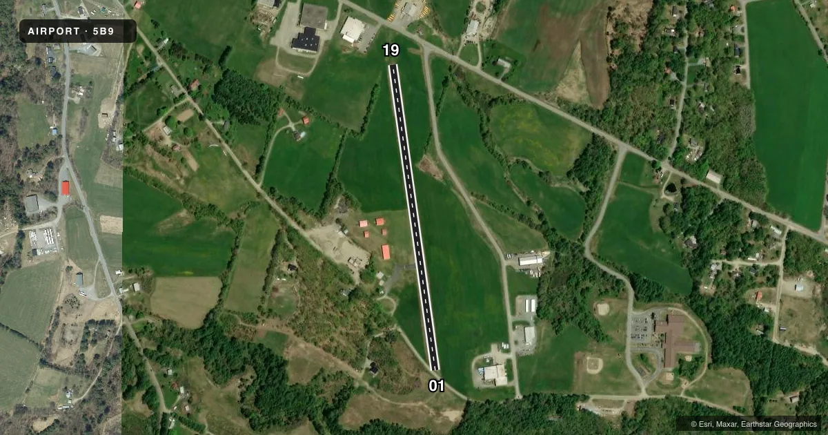
Runways & pattern
Full pagePattern entry · RWY 01
LEFT TRAFFICRunway end performance
| End | TORA | TODA | ASDA | LDA | VGSI | Approach lights | Obstruction |
|---|---|---|---|---|---|---|---|
| 01 | — | — | — | — | — | — | 100', trees, 368' from thr, 257' R of cntrln, slope 1 |
| 19 | — | — | — | — | — | — | 36', pole, 244' from thr, 171' R of cntrln, slope 1 |
Declared distances in feet. TORA = takeoff run available, TODA = takeoff distance, ASDA = accelerate-stop, LDA = landing distance.
Airport sketch
Runways drawn to scale from FAA survey coordinates, rendered over satellite imagery. Not for navigation.
Approaches & charts
Services on the field
Fuel grades, oxygen, maintenance, ramp storage and lighting — as declared to the FAA by the airport operator.
Fuel & services
- Fuel
- 100LL
- Oxygen (bottled)
- Not available
- Oxygen (bulk)
- Not available
- Airframe repair
- Not available
- Power plant repair
- Not available
Ramp & ground
- Transient storage
- Tie-down
- Landing fee
- No fee published
- Customs
- Not available
- Lighting schedule
- SEE RMK
- Wind indicator
- Lighted
- Segmented circle
- No
Fuel & FBOs
Cheapest 100LL and Jet A on the field and nearby. Always confirm with the FBO before taxi.
Airport notes
Surface conditions, obstructions, local procedures, lighting outages and other notes published with each FAA cycle.
General notes
- FOR WINTER CONDS CALL 603-346-0445 24 HRS BFR USE.
- FOR CD CTC BOSTON ARTCC AT 603-879-6859.
- COLD TEMPERATURE AIRPORT. ALTITUDE CORRECTION REQUIRED AT OR BELOW -27C.
Lighting notes
- ACTVT LIRL RWY 01/19 & WINDSOCK - CTAF.
Fuel notes
- 100LLFUEL AVBL 24 HRS.
Runway surface & condition
- 01/19NSTD SPACING, FIRST 185 FT RWY 01 UNLGTD.
Other notes
- VFR OPS ONLY.
- OWNERDEAN MEMORIAL ARPT COMMISSION.
VFR map & nearby airports
VFR sectional. Tap any ICAO chip to open that airport.
Key facts · 5B9
Answer card- ICAO
- 5B9
- Name
- DEAN MEML
- Location
- HAVERHILL, NEW HAMPSHIRE
- Elevation
- 581.7 ft MSL
- Traffic pattern altitude
- 1,581.7 ft MSL (1,000 AGL)
- Control tower
- Non-towered (use CTAF)
- Total runways
- 1
- Longest runway
- 01/19 · 2,511 ft
- Published ILS approaches
- 0
- Published frequencies
- 2
- Magnetic variation
- 16°
- Current flight rules
- VFR
- Current wind
- 000° at 0 kt
- Favored runway now
- –
Dean Memorial Airport sits in Haverhill, New Hampshire. Field elevation is 581.7 ft MSL. The airport has one runway. Runway 01/19 is 2,511 ft long and asphalt. There is no control tower. CTAF and UNICOM are both 122.8.
No ILS approaches are published here. Pattern altitude is not published, so use the standard 1,000 ft AGL for light piston traffic unless the current FAA Chart Supplement says otherwise. The field is VFR only. That matters here because you need to plan for visual conditions and stay current on weather before departing or arriving.
Dean Memorial Airport has one on-field FBO. Dean Memorial Airport carries 100LL. Fuel is available 24 hours. The published remarks also note low intensity runway lights on 01/19 that are activated by CTAF. The first 185 ft of runway 01 is unlighted, so night ops need a careful look at the runway environment before landing. For clearance delivery, contact Boston ARTCC at the listed number. In winter, call ahead 24 hours before use. The airport is also a cold temperature airport, so altitude correction is required at or below minus 27 degrees Celsius.