METAR & TAF 2B9
2B9 does not publish a METAR.
Showing the nearest reporting station: KLEB (LEBANON MUNI) · 15.6 NM away. Conditions at 2B9 may differ.
METAR · KLEB
Observed 04:53Z
KLEB 270453Z AUTO 00000KT 10SM CLR 14/13 A2986 RMK AO2 SLP104 T01390133 402890106
- Wind
- 000° @ 0 kt
- Visibility
- 10 SM
- Temp / Dew
- 14°C / 13°C
- Altimeter
- 29.86 inHg
- Clouds
- CLR
- Density alt
- 817 ft
- Ceiling
- Unlimited
- Rules
- VFR
Airport info & contacts
Manager on record, flight service, ARTCC, attendance schedule and pattern altitude — published by the FAA and refreshed every 28 days.
Location
- From city
- 0 NM E
- VFR sectional
- NEW YORK
- ARTCC
- ZBW · BOSTON
- NOTAM facility
- BTV (NOTAM-D)
Airport manager
- Name
- ANDY LUMLEY
- Phone
- 802-266-1355
- Address
- PO BOX 12, POST MILLS VT 05058
Flight service · Hours
- FSS BTV
- BURLINGTON1-800-WX-BRIEF
- Attendance
- IREG
Frequencies
Tap any row to copy the frequency to your clipboard.
Runways & pattern
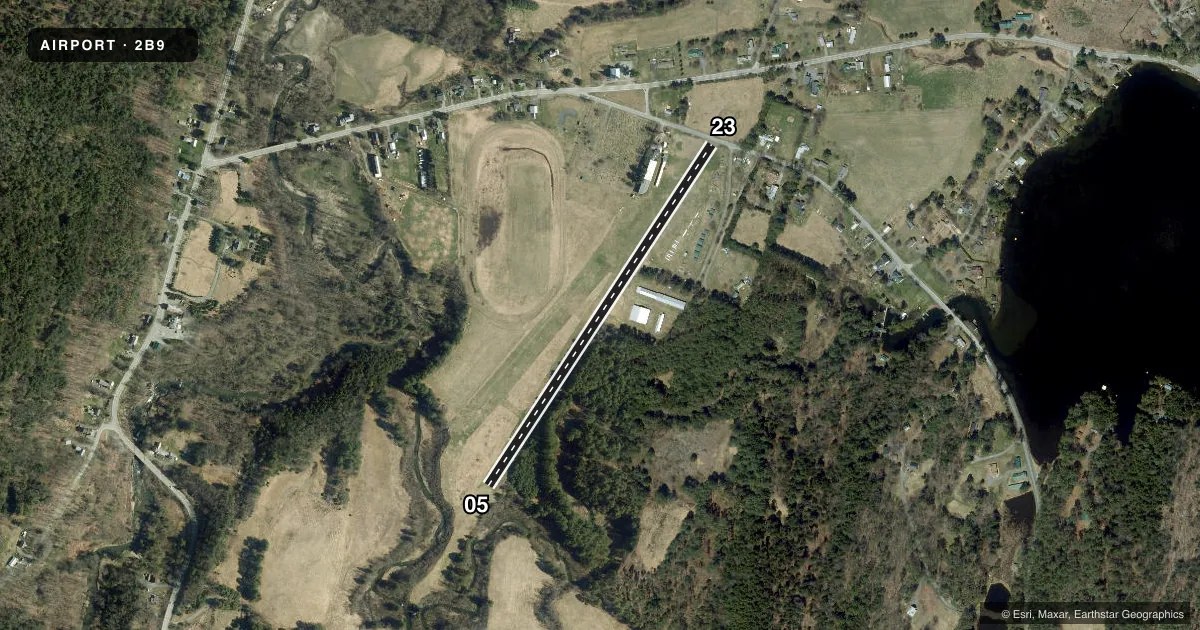
Full pagePattern entry · RWY 05
RIGHT TRAFFICRunway end performance
| End | TORA | TODA | ASDA | LDA | VGSI | Approach lights | Obstruction |
|---|---|---|---|---|---|---|---|
| 05 | — | — | — | — | — | — | 70', trees, 0' from thr, 40' R of cntrln, slope 0 |
| 23 | — | — | — | — | — | — | 15', road, 0' from thr, 125' R of cntrln, slope 0 |
Declared distances in feet. TORA = takeoff run available, TODA = takeoff distance, ASDA = accelerate-stop, LDA = landing distance.
Airport sketch
Runways drawn to scale from FAA survey coordinates, rendered over satellite imagery. Not for navigation.
Approaches & charts
Services on the field
Fuel grades, oxygen, maintenance, ramp storage and lighting — as declared to the FAA by the airport operator.
Fuel & services
- Fuel
- Not available
- Oxygen (bottled)
- Not available
- Oxygen (bulk)
- Not available
- Other services
- GLD,TOW
Ramp & ground
- Transient storage
- Tie-down
- Hangar
- Landing fee
- No fee published
- Customs
- Not available
- Wind indicator
- Yes
- Segmented circle
- Yes
Fuel & FBOs
Cheapest 100LL and Jet A on the field and nearby. Always confirm with the FBO before taxi.
Airport notes
Surface conditions, obstructions, local procedures, lighting outages and other notes published with each FAA cycle.
General notes
- ARPT OPEN TO SKI ACFT ONLY WHEN SN CVRD. NO SN REMOVAL. SEE SNOWTAM RPRTS.
- ULTRALIGHTS; GLIDERS & HOT AIR BALLOONS ON & INVOF ARPT.
- (A70) PROPANE AVBL FOR HOT AIR BALLOONS.
- FOR CD CTC BOSTON ARTCC AT 603-879-6859.
- RWY 4/22: 70 FT TREES, 40 FT E OF CNTRLN, S 1700 FT.
Approach & departure obstructions
- 0470 FT TREES AT RWY EDGE, 40 FT L.
- 0570 FT TREES AT RWY EDGE, 40 FT L.
Other notes
- ARPT EXISTED PRIOR TO 1959.
VFR map & nearby airports
VFR sectional. Tap any ICAO chip to open that airport.
Key facts · 2B9
Answer card- ICAO
- 2B9
- Name
- POST MILLS
- Location
- POST MILLS, VERMONT
- Elevation
- 696 ft MSL
- Traffic pattern altitude
- 1,696 ft MSL (1,000 AGL)
- Control tower
- Non-towered (use CTAF)
- Total runways
- 1
- Longest runway
- 05/23 · 2,300 ft
- Published ILS approaches
- 0
- Published frequencies
- 2
- Magnetic variation
- 16°
- Current flight rules
- VFR
- Current wind
- 000° at 0 kt
- Favored runway now
- –
Post Mills Airport is in Post Mills, Vermont. The field elevation is 696 ft MSL. It has one runway. Runway 05/23 is 2,300 ft of turf. There is no control tower. CTAF and UNICOM are both 122.8. No ILS approaches are published.
The pattern altitude is not published. Use 1,000 ft AGL for light piston operations unless the current Chart Supplement says otherwise. The airport sits in a mixed-use environment. Ultralights, gliders and hot air balloons operate on and near the field. That makes a good lookout important in the pattern and on short final. The published remarks also note trees near the runway edge. There are 70-foot trees close to the runway on the 05 side. The field is open to ski aircraft only when snow covered. No snow removal is performed. Check snow conditions before planning a winter arrival.
There are no on-field FBOs listed. Contact the airport operator directly before arrival, or call the field on CTAF or UNICOM for current service status. If you need clearance delivery, Boston ARTCC is listed in the remarks. This is a turf strip with limited runway length. Plan your performance carefully, especially if the surface is soft or snow covered.