METAR & TAF 1P1
Current METAR
Observed 13:35Z
K1P1 271335Z AUTO 00000KT 10SM CLR 20/14 A2985 RMK AO2 T02010140
- Wind
- 000° @ 0 kt
- Visibility
- 10 SM
- Temp / Dew
- 20°C / 14°C
- Altimeter
- 29.85 inHg
- Clouds
- CLR
- Density alt
- 1,314 ft
- Ceiling
- Unlimited
- Rules
- VFR
Airport info & contacts
Manager on record, flight service, ARTCC, attendance schedule and pattern altitude — published by the FAA and refreshed every 28 days.
Location
- From city
- 3 NM NW
- VFR sectional
- NEW YORK
- ARTCC
- ZBW · BOSTON
- NOTAM facility
- BGR (NOTAM-D)
Airport manager
- Name
- COLIN MCIVER
- Phone
- 603-536-5818
- Address
- 6 POST OFFICE SQUARE, PLYMOUTH NH 03264
Flight service · Hours
- FSS BGR
- BANGOR1-800-WX-BRIEF
- Attendance
- IREG
Frequencies
Tap any row to copy the frequency to your clipboard.
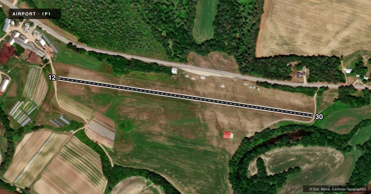
Runways & pattern
Full pagePattern entry · RWY 12
LEFT TRAFFICRunway end performance
| End | TORA | TODA | ASDA | LDA | VGSI | Approach lights | Obstruction |
|---|---|---|---|---|---|---|---|
| 12 | — | — | — | — | — | — | 6', road, 47' from thr, 5' R of cntrln, slope 0 |
| 30 | — | — | — | — | — | — | 10', road, 14' from thr, slope 0 |
Declared distances in feet. TORA = takeoff run available, TODA = takeoff distance, ASDA = accelerate-stop, LDA = landing distance.
Airport sketch
Runways drawn to scale from FAA survey coordinates, rendered over satellite imagery. Not for navigation.
Approaches & charts
Services on the field
Fuel grades, oxygen, maintenance, ramp storage and lighting — as declared to the FAA by the airport operator.
Fuel & services
- Fuel
- Not available
- Oxygen (bottled)
- Not available
- Oxygen (bulk)
- Not available
Ramp & ground
- Transient storage
- Tie-down
- Landing fee
- No fee published
- Customs
- Not available
- Wind indicator
- Yes
- Segmented circle
- No
Fuel & FBOs
Cheapest 100LL and Jet A on the field and nearby. Always confirm with the FBO before taxi.
Airport notes
Surface conditions, obstructions, local procedures, lighting outages and other notes published with each FAA cycle.
General notes
- RWY 12/30 STRIP SOFT IN SPRING. NOT MAINTAINED IN WINTER BUT OPEN TO SKI CRAFT. PLEASE CALL AHEAD.
- ULTRALIGHT & PARAGLIDER ACT ON & INVOF ARPT.
- NMRS NON-RADIO EQUIPPED ACFT OPERATING FM ARPT.
- 1161 FT MSL MOUNTAIN 1.5 NM N OF RWY 30 L OF CNTRLN.
- WILDLIFE ON & INVOF ARPT.
- +3 FT DRAINAGE SWALES LCTD 15 FT FM EDGE, BOTH SIDES OF RWY BGNG AT MIDFIELD THEN W FOR 700 FT.
- HVY PWRD PRCHT & WT SHIFT CTL ACFT ACT ONLY IN R TFC BLW 400 FT AGL FOR RWY 12.
- FOR CD CTC BOSTON ARTCC AT 603-879-6859.
Approach & departure obstructions
- 12RWY 12/30 EDGES & ENDS MKD BY YELLOW CONES. RWY 12 & 30 DTHRS MKD BY TWO YELLOW CONES ALIGNED PERPENDICULAR TO EACH RWY EDGE.
- 12CTLG OBSTN EXCEEDS A 45 DEG SLP.
- 12FARM ACCESS ROAD 30 FT FM THR.
Other notes
- ARPT ESTAB PRIOR 1959
- 1ARPT ATNDD IREGLY CALL 603-536-5818.
- OWNERARPT FONE 603-536-5818.
VFR map & nearby airports
VFR sectional. Tap any ICAO chip to open that airport.
Key facts · 1P1
Answer card- ICAO
- 1P1
- Name
- PLYMOUTH MUNI
- Location
- PLYMOUTH, NEW HAMPSHIRE
- Elevation
- 506 ft MSL
- Traffic pattern altitude
- 1,506 ft MSL (1,000 AGL)
- Control tower
- Non-towered (use CTAF)
- Total runways
- 1
- Longest runway
- 12/30 · 2,347 ft
- Published ILS approaches
- 0
- Published frequencies
- 2
- Magnetic variation
- 16°
- Current flight rules
- VFR
- Current wind
- 000° at 0 kt
- Favored runway now
- –
Plymouth Muni is in Plymouth, New Hampshire. The field elevation is 506 ft MSL. It has one runway, 12/30, which is 2,347 ft of turf. There is no control tower. CTAF and UNICOM are both 122.8. No ILS approaches are published here.
The pattern altitude is not published. Use the standard 1,000 ft AGL for light piston operations unless the current FAA Chart Supplement says otherwise. That puts the pattern at 1,506 ft MSL based on the field elevation. The runway markings use yellow cones. The displaced thresholds are also marked with cones.
This is a field where local conditions matter. The runway strip is soft in spring. It is not maintained in winter, though ski aircraft may still use it. Call ahead before you go. There is also a 1,161 ft MSL mountain about 1.5 NM north of runway 30, left of centerline. Wildlife is reported on and near the airport. Ultralight and paraglider activity also occurs here. The airport is attended irregularly. The airport phone is 603-536-5818. For clearance delivery, contact Boston ARTCC at 603-879-6859.