METAR & TAF 4MB
4MB does not publish a METAR.
Showing the nearest reporting station: KLCI (LACONIA MUNI) · 11.7 NM away. Conditions at 4MB may differ.
METAR · KLCI
Observed 11:56Z
KLCI 271156Z AUTO 00000KT 10SM CLR 18/13 A2986 RMK AO2 SLP109 T01780133 10178 20122 53004 PWINO $
- Wind
- 000° @ 0 kt
- Visibility
- 10 SM
- Temp / Dew
- 18°C / 13°C
- Altimeter
- 29.86 inHg
- Clouds
- CLR
- Density alt
- 1,149 ft
- Ceiling
- Unlimited
- Rules
- VFR
Airport info & contacts
Manager on record, flight service, ARTCC, attendance schedule and pattern altitude — published by the FAA and refreshed every 28 days.
Location
- From city
- 1 NM NE
- VFR sectional
- NEW YORK
- ARTCC
- ZBW · BOSTON
- NOTAM facility
- BGR (NOTAM-D)
Airport manager
- Name
- JOHN ST. AMAND
- Phone
- 508-479-8301
- Address
- 39 AIRPORT RD, MOULTONBOROUGH NH 03254
Flight service · Hours
- FSS BGR
- BANGOR1-800-WX-BRIEF
- Attendance
- MAY-OCT · MON-FRI · IREG
- MAY-OCT · SAT-SUN · IREG
- OCT-MAY · APPOINTMENT
Frequencies
Tap any row to copy the frequency to your clipboard.
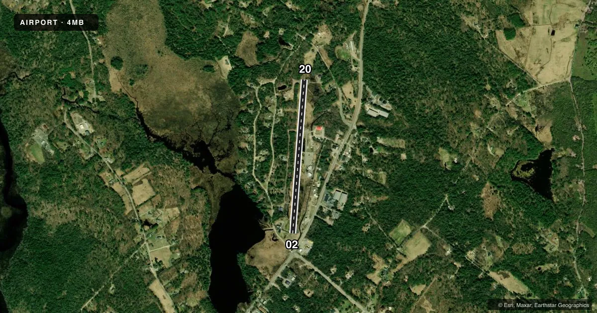
Runways & pattern
Full pagePattern entry · RWY 02
LEFT TRAFFICRunway end performance
| End | TORA | TODA | ASDA | LDA | VGSI | Approach lights | Obstruction |
|---|---|---|---|---|---|---|---|
| 02 | — | — | — | — | — | — | 79', trees, 616' from thr, 153' R of cntrln, slope 5 |
| 20 | — | — | — | — | — | — | 46', trees, 214' from thr, 53' R of cntrln, slope 0 |
Declared distances in feet. TORA = takeoff run available, TODA = takeoff distance, ASDA = accelerate-stop, LDA = landing distance.
Airport sketch
Runways drawn to scale from FAA survey coordinates, rendered over satellite imagery. Not for navigation.
Approaches & charts
Services on the field
Fuel grades, oxygen, maintenance, ramp storage and lighting — as declared to the FAA by the airport operator.
Fuel & services
- Fuel
- 100LL
- Oxygen (bottled)
- Not available
- Oxygen (bulk)
- Not available
- Airframe repair
- Major
- Power plant repair
- Major
- Other services
- CHTR,INSTR,RNTL
Ramp & ground
- Transient storage
- Tie-down
- Hangar
- Landing fee
- No fee published
- Lighting schedule
- SEE RMK
- Beacon schedule
- SEE RMK
- Beacon
- White / Green (civil land)(WG)
- Wind indicator
- Yes
- Segmented circle
- No
Fuel & FBOs
Cheapest 100LL and Jet A on the field and nearby. Always confirm with the FBO before taxi.
Airport notes
Surface conditions, obstructions, local procedures, lighting outages and other notes published with each FAA cycle.
General notes
- RWY 2 PLINE MKRS FADED.
- WILDLIFE ON & INVOF ARPT.
- NMRS NON-RADIO EQUIPPED ACFT OPRG FM AIRFLD.
- RWY 2 DESIGNATED CALM WIND RWY.
- COURTESY CAR AVBL ON REQ.
- FLOAT PLANE ACCESS TO & FM BERRY POND.
- FOR CD CTC BOSTON ARTCC AT 603-879-8659.
- OVERFLY RWY TO CHECK FOR WILDLIFE.
Lighting notes
- ACTVT ROTG BCN - CTAF. 5 CLICKS ON, 3 CLICKS OFF.
- ACTVT NON-STD LIRL RWY 02/20 - CTAF. 5 CLICKS ON & 3 CLICKS OFF.
Fuel notes
- 100LL24 HR SELF SVC FUEL AVBL WITH CREDIT CARD.
Runway surface & condition
- 02/20RWY 02/20 NON-STD LIRL, LGTS ARE 4 FT HIGH. LGTD ONLY BTN DTHR, VRB SPACING, 2890 FT OF RWY LGTD.
Approach & departure obstructions
- 02DTHR AREA MARKINGS NON-STD SIZE & SPACING.
- 20RWY 2/20 NON-STD CNTRLN SIZE & SPACING. DTHR NOT MKD.
- 02ROADWAY 215-390 FT FM RWY, L & R OF CNTRLN.
- 02APCH SLOPE 15:1 TO DTHR. CTLG OBSTN EXCEEDS A 45 DEG SLP.
Other notes
- VFR ONLY.
- 15MI N LACONIA.
- CONT LGTD DUSK-DAWN.
VFR map & nearby airports
VFR sectional. Tap any ICAO chip to open that airport.
Key facts · 4MB
Answer card- ICAO
- 4MB
- Name
- MOULTONBOROUGH
- Location
- MOULTONBOROUGH, NEW HAMPSHIRE
- Elevation
- 576 ft MSL
- Traffic pattern altitude
- 1,576 ft MSL (1,000 AGL)
- Control tower
- Non-towered (use CTAF)
- Total runways
- 1
- Longest runway
- 02/20 · 3,505 ft
- Published ILS approaches
- 0
- Published frequencies
- 2
- Magnetic variation
- 16°
- Current flight rules
- VFR
- Current wind
- 000° at 0 kt
- Favored runway now
- –
Moultonborough Airport sits in Moultonborough, New Hampshire. Field elevation is 576 ft MSL. The airport has one runway. Runway 02/20 is 3,505 ft long and paved with asphalt. There is no control tower. CTAF and UNICOM are both 122.8. No ILS approaches are published here. Pattern altitude is not published, so use the standard 1,000 ft AGL for light piston traffic unless the current Chart Supplement says otherwise.
The field is VFR only. That matters here because the published remarks also call out non-radio aircraft, wildlife in the area and a roadway close to both sides of the runway environment. Runway 02 is the calm wind runway. The runway 02 displaced threshold is not marked. The approach to that displaced threshold has a steep slope, so brief your landing distance carefully. The runway lighting is non-standard low intensity. It is activated from CTAF by keying the mic five times. The rotating beacon uses the same five-click method.
Moultonborough Airport has one on-field FBO. Moultonborough Airport is listed on the field. Fuel grades are not reported in the facts, so confirm current fuel availability with the FBO directly by phone before departure. A courtesy car is available on request. Float plane access is also available to and from Berry Pond.