METAR & TAF 63B
63B does not publish a METAR.
Showing the nearest reporting station: KPWM (PORTLAND INTL JETPORT) · 17.3 NM away. Conditions at 63B may differ.
METAR · KPWM
Observed 05:51Z
KPWM 270551Z AUTO 00000KT 10SM CLR 11/09 A2985 RMK AO2 SLP108 T01110089 10178 20106 56010 $
- Wind
- 000° @ 0 kt
- Visibility
- 10 SM
- Temp / Dew
- 11°C / 9°C
- Altimeter
- 29.85 inHg
- Clouds
- CLR
- Density alt
- -31 ft
- Ceiling
- Unlimited
- Rules
- VFR
Airport info & contacts
Manager on record, flight service, ARTCC, attendance schedule and pattern altitude — published by the FAA and refreshed every 28 days.
Location
- From city
- 3 NM N
- VFR sectional
- NEW YORK
- Pattern altitude
- 1,100 ft AGL · 1,392 ft MSL
- ARTCC
- ZBW · BOSTON
- NOTAM facility
- BGR (NOTAM-D)
Airport manager
- Name
- KYLE STARKWEATHER
- Phone
- 207-200-7548
- Address
- 12 CROWHILL RD, ROCHESTER NH 03868
Flight service · Hours
- FSS BGR
- BANGOR1-800-WX-BRIEF
- Attendance
- Unattended
Frequencies
Tap any row to copy the frequency to your clipboard.
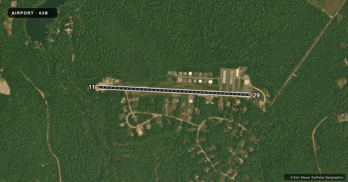
Runways & pattern
Full pagePattern entry · RWY 11
LEFT TRAFFICRunway end performance
| End | TORA | TODA | ASDA | LDA | VGSI | Approach lights | Obstruction |
|---|---|---|---|---|---|---|---|
| 11 | — | — | — | — | — | — | 25', trees, 201' from thr, 140' R of cntrln, slope 0 |
| 29 | — | — | — | — | — | — | 40', trees, 201' from thr, 201' R of cntrln, slope 0 |
Declared distances in feet. TORA = takeoff run available, TODA = takeoff distance, ASDA = accelerate-stop, LDA = landing distance.
Airport sketch
Runways drawn to scale from FAA survey coordinates, rendered over satellite imagery. Not for navigation.
Approaches & charts
Services on the field
Fuel grades, oxygen, maintenance, ramp storage and lighting — as declared to the FAA by the airport operator.
Fuel & services
- Fuel
- 100LL
- Airframe repair
- Not available
- Power plant repair
- Not available
Ramp & ground
- Transient storage
- Tie-down
- Hangar
- Landing fee
- No fee published
- Lighting schedule
- SEE RMK
- Wind indicator
- Lighted
- Segmented circle
- No
Fuel & FBOs
Cheapest 100LL and Jet A on the field and nearby. Always confirm with the FBO before taxi.
Airport notes
Surface conditions, obstructions, local procedures, lighting outages and other notes published with each FAA cycle.
General notes
- WILDLIFE ON OR INVOF ARPT.
- FOR CD CTC PORTLAND APCH AT 207-874-7320, WHEN APCH CLSD CTC BOSTON ARTCC AT 603-879-6859.
- +8-20 FT TREES, 50-125 FT FM CNTRLN S SIDE OF RWY, 200-500 FT FM THR.EASTWARD.
Lighting notes
- ACTVT LIRL RWY 11/29 5 CLICKS - CTAF.
Fuel notes
- 100LL24 HR SELF-SERVE FUEL WITH MAJOR CREDIT CARD.
Runway surface & condition
- 11/29NON-STD LIRL. RWY 29 HAS ONE THR LGT 175 FT FM THR, RWY 11 HAS TWO THR LGTS 320 FT FM THR, RWY LGTS SPACED AT 400 FT, MANY LGTS MISG.
Approach & departure obstructions
- 11+2 FT -20 FT BRUSH & TREES 0-200 FT FM THR, 0 FT B; +3 FT -5 FT DITCH 0-200 FT FM THR, 50 FT R OF CNTRLN.
- 29+15 FT ROAD 50-200 FT FM THR 0-125 FT R; +25 FT POLE 50 FT FM THR 100 FT R; +35 FT PWR LINE 0-200 FT FM THR, 125 FT R; FUEL TANK 0 FT FM THR, 125 FT R.
- 11MKD AS BASIC, NRS DSPLCD 145 FT FM THR, NRS & CNTRLN FADED.
- 29MKD AS BASIC, NRS DSPLCD 167 FT FM THR, NRS & CNTRLN FADED.
- 11CTLG OBSTN EXCEEDS 45 DEG SLP.
Other notes
- THIS AIRPORT HAS BEEN SURVEYED BY THE NATIONAL GEODETIC SURVEY.
- VFR ONLY.
- CALL AHD FOR HNGR AVBLY.
- 11/29SVRLY CRACKED, SHALLOW POTHOLES, LOOSE AGGRETATE ON RWY.
VFR map & nearby airports
VFR sectional. Tap any ICAO chip to open that airport.
Key facts · 63B
Answer card- ICAO
- 63B
- Name
- LIMINGTON-HARMON
- Location
- LIMINGTON, MAINE
- Elevation
- 292.3 ft MSL
- Traffic pattern altitude
- 1,392.3 ft MSL (1,100 AGL)
- Control tower
- Non-towered (use CTAF)
- Total runways
- 1
- Longest runway
- 11/29 · 2,973 ft
- Published ILS approaches
- 0
- Published frequencies
- 3
- Magnetic variation
- 17°
- Current flight rules
- VFR
- Current wind
- 000° at 0 kt
- Favored runway now
- –
Limington-Harmon Airport is in Limington, Maine. Field elevation is 292.3 ft MSL. It has one runway, 11/29, which is 2,973 ft long and asphalt. There is no control tower. Pattern altitude is 1,100 ft AGL, which is 1,392.3 ft MSL.
No ILS approaches are published here. This is a VFR-only airport. For clearance delivery, contact Portland Approach at 207-874-7320. When approach is closed, contact Boston ARTCC at 603-879-6859. CTAF and UNICOM are both 122.7, so expect self-announce traffic in the pattern.
Runway lighting is non-standard low intensity. Click the CTAF five times to activate the lights. Runway 29 has one threshold light 175 feet from the threshold. Runway 11 has two threshold lights 320 feet from the threshold. Many lights are missing. The runway is also severely cracked with shallow potholes and loose aggregate.
Published remarks also note trees on the south side of the runway near the east end, plus wildlife on or near the airport. Runway 11 and Runway 29 both have displaced numbers and faded markings. There are no on-field FBOs listed. Call ahead for hangar availability before you go.