METAR & TAF B19
B19 does not publish a METAR.
Showing the nearest reporting station: KSFM (SANFORD SEACOAST RGNL) · 11.1 NM away. Conditions at B19 may differ.
METAR · KSFM
Observed 20:56Z
KSFM 262056Z AUTO VRB06KT 10SM CLR 22/11 A2989 RMK AO2 SLP124 T02220111 58012
- Wind
- VAR @ 6 kt
- Visibility
- 10 SM
- Temp / Dew
- 22°C / 11°C
- Altimeter
- 29.89 inHg
- Clouds
- CLR
- Density alt
- 1,072 ft
- Ceiling
- Unlimited
- Rules
- VFR
Airport info & contacts
Manager on record, flight service, ARTCC, attendance schedule and pattern altitude — published by the FAA and refreshed every 28 days.
Location
- From city
- 2 NM S
- VFR sectional
- NEW YORK
- Pattern altitude
- 838 ft AGL · 995 ft MSL
- ARTCC
- ZBW · BOSTON
- NOTAM facility
- BGR (NOTAM-D)
Airport manager
- Name
- JEFF DEMERS
- Phone
- 207-282-1579
- Address
- 371 HILL STREET, BIDDEFORD ME 04005
Flight service · Hours
- FSS BGR
- BANGOR1-800-WX-BRIEF
- Attendance
- MON-THUR · 1000-1600
- SAT-SUN · 0900-1600
Frequencies
Tap any row to copy the frequency to your clipboard.
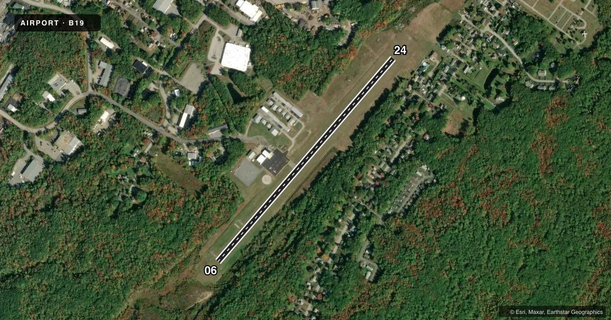
Runways & pattern
Full pagePattern entry · RWY 06
LEFT TRAFFICRunway end performance
| End | TORA | TODA | ASDA | LDA | VGSI | Approach lights | Obstruction |
|---|---|---|---|---|---|---|---|
| 06 | — | — | — | — | PAPI 4-box left(3.5°) | — | 6', brush, 220' from thr, 115' R of cntrln, slope 3 |
| 24 | — | — | — | — | — | — | 3', brush, 204' from thr, 130' R of cntrln, slope 1 |
Declared distances in feet. TORA = takeoff run available, TODA = takeoff distance, ASDA = accelerate-stop, LDA = landing distance.
Airport sketch
Runways drawn to scale from FAA survey coordinates, rendered over satellite imagery. Not for navigation.
Approaches & charts
Services on the field
Fuel grades, oxygen, maintenance, ramp storage and lighting — as declared to the FAA by the airport operator.
Fuel & services
- Fuel
- 100LL
- Oxygen (bottled)
- Not available
- Oxygen (bulk)
- Not available
- Airframe repair
- Not available
- Power plant repair
- Not available
- Other services
- PAJA
Ramp & ground
- Transient storage
- Tie-down
- Hangar
- Landing fee
- No fee published
- Customs
- Not available
- Lighting schedule
- SEE RMK
- Beacon schedule
- SS-SR
- Beacon
- White / Green (civil land)(WG)
- Wind indicator
- Lighted
- Segmented circle
- No
Fuel & FBOs
Cheapest 100LL and Jet A on the field and nearby. Always confirm with the FBO before taxi.
Airport notes
Surface conditions, obstructions, local procedures, lighting outages and other notes published with each FAA cycle.
General notes
- DEER & TURKEYS ON & INVOF ARPT.
- NOISE ABATEMENT CTC AMGR FOR DTLS.
- ULTRALIGHT & PRCHT ACT ON & INVOF ARPT.
- FOR CD CTC PORTLAND APCH AT 207-874-7320, WHEN APCH CLSD CTC BOSTON ARTCC AT 603-879-6859.
- BANNER TOWING AVBL.
Lighting notes
- ACTVT REIL RWY 06; PAPI RWY 06; MIRL RWY 06/24 - CTAF.
Fuel notes
- 100LL24 HR FUEL W/MAJOR CREDIT CARD - SELF SVC.
Approach & departure obstructions
- 067 FT BRUSH 78 FT FM THR, 151 FT R OF CNTRLN; 5 FT BRUSH 114 FT FM THR, 166 FT L OF CNTRLN.
- 24+6-8 FT BRUSH & ROCK LEDGE 10-55 FT FM THR, 228 FT R OF CNTRLN.
- 24CALM WIND RWY.
Other notes
- THIS AIRPORT HAS BEEN SURVEYED BY THE NATIONAL GEODETIC SURVEY.
- EXISTED PRIOR TO 1959.
- CALL AHD FOR HNGR AVBLTY.
- MANAGERPUB WORKS DEPT.
VFR map & nearby airports
VFR sectional. Tap any ICAO chip to open that airport.
Key facts · B19
Answer card- ICAO
- B19
- Name
- BIDDEFORD MUNI
- Location
- BIDDEFORD, MAINE
- Elevation
- 157 ft MSL
- Traffic pattern altitude
- 995 ft MSL (838 AGL)
- Control tower
- Non-towered (use CTAF)
- Total runways
- 1
- Longest runway
- 06/24 · 3,000 ft
- Published ILS approaches
- 0
- Published frequencies
- 4
- Magnetic variation
- 17°
- Current flight rules
- VFR
- Current wind
- 000° at 6 kt
- Favored runway now
- RWY 06
Biddeford Muni sits in Biddeford, Maine. Field elevation is 157 ft MSL. The airport has one runway, 06/24, which is 3,000 ft long. There is no control tower. Pattern altitude is 838 ft AGL, which is 995 ft MSL. No ILS approaches are published here, so plan with the current charted procedures and the weather on the day of flight.
The on-field FBO is Biddeford Municipal Airport. It carries 100LL. Twenty-four hour self-serve fuel is available with a major credit card. Runway 06 has REIL and PAPI lighting. Runways 06 and 24 have medium intensity runway lighting controlled by CTAF. Ultralight and parachute activity occurs on and near the airport, so keep your scan active in the pattern. Runway 06 has brush close to the threshold on both sides. Runway 24 has brush and a rock ledge near the threshold on the right side.
For clearance delivery, contact Portland Approach. When Approach is closed, contact Boston ARTCC. The airport manager is the Public Works Department. Call ahead for hangar availability. If you need noise abatement details, check with the airport manager before you go.