METAR & TAF KPSM
Current METAR
Observed 12:55Z
KPSM 271255Z 00000KT 10SM FEW100 21/14 A2984 RMK AO2A SLP107 T02090141
- Wind
- 000° @ 0 kt
- Visibility
- 10 SM
- Temp / Dew
- 21°C / 14°C
- Altimeter
- 29.84 inHg
- Clouds
- FEW
- Density alt
- 944 ft
- Ceiling
- Unlimited
- Rules
- VFR
Airport info & contacts
Manager on record, flight service, ARTCC, attendance schedule and pattern altitude — published by the FAA and refreshed every 28 days.
Location
- From city
- 1 NM W
- VFR sectional
- NEW YORK
- ARTCC
- ZBW · BOSTON
- NOTAM facility
- PSM (NOTAM-D)
Airport manager
- Name
- JOHN MEEHAN
- Phone
- 603-766-9238
- Address
- 36 AIRLINE DR, PORTSMOUTH NH 03801
Flight service · Hours
- FSS BGR
- BANGOR1-800-WX-BRIEF
- Attendance
- ALL
Frequencies
Tap any row to copy the frequency to your clipboard.
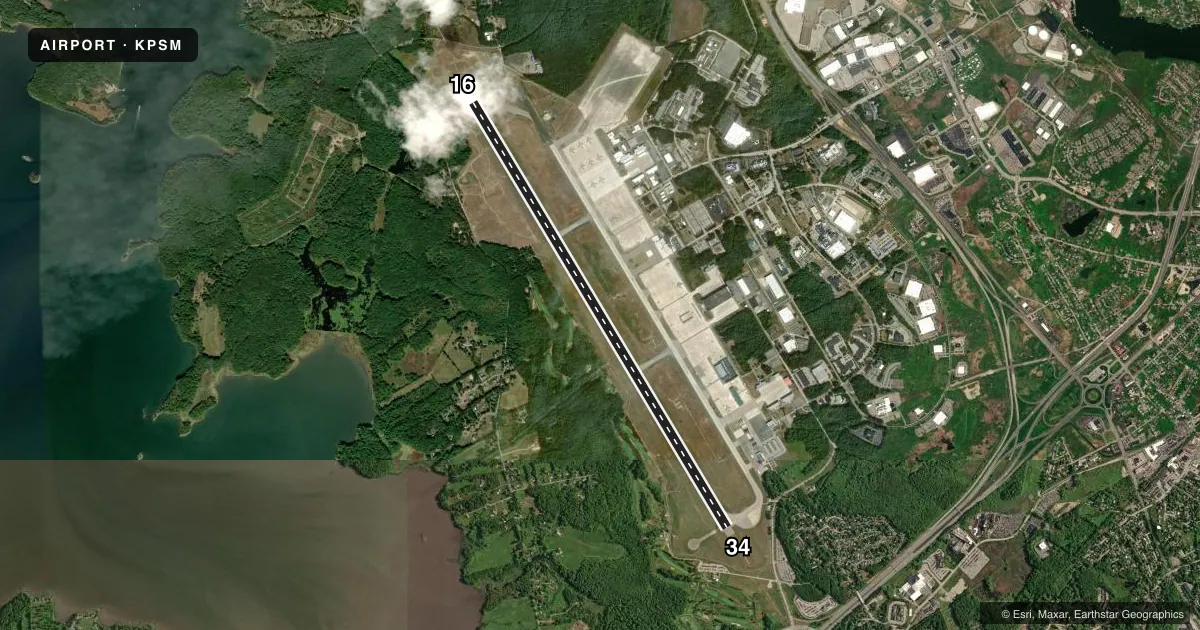
Runways & pattern
Full pagePattern entry · RWY 16
RIGHT TRAFFICRunway end performance
| End | TORA | TODA | ASDA | LDA | VGSI | Approach lights | Obstruction |
|---|---|---|---|---|---|---|---|
| 16 | 11,321' | 11,321' | 11,321' | 10,518' | PAPI 4-box left(3°) | MALSR | 58', trees, 2200' from thr, 0' R of cntrln, slope 34 |
| 34 | 11,321' | 11,321' | 11,321' | 11,321' | PAPI 4-box left(3°) | MALSR | — |
Declared distances in feet. TORA = takeoff run available, TODA = takeoff distance, ASDA = accelerate-stop, LDA = landing distance.
Airport sketch
Runways drawn to scale from FAA survey coordinates, rendered over satellite imagery. Not for navigation.
Approaches & charts
ILS · 2
Services on the field
Fuel grades, oxygen, maintenance, ramp storage and lighting — as declared to the FAA by the airport operator.
Fuel & services
- Fuel
- 100LLAJ8
- Oxygen (bottled)
- HIGH/LOW
- Airframe repair
- Major
- Power plant repair
- Major
- Other services
- CARGO,CHTR,INSTR,RNTL
Ramp & ground
- Transient storage
- Tie-down
- Hangar
- Landing fee
- No fee published
- Customs
- Not available
- Beacon schedule
- SS-SR
- Beacon
- White / Green (civil land)(WG)
- Wind indicator
- Lighted
- Segmented circle
- No
Fuel & FBOs
Cheapest 100LL and Jet A on the field and nearby. Always confirm with the FBO before taxi.
Airport notes
Surface conditions, obstructions, local procedures, lighting outages and other notes published with each FAA cycle.
General notes
- ALL INBD ACFT WITH HAZUS CARGO INFO CALL ATCT 60 NM OUT.
- TURB APCH END RWY 34 IN STRONG X WINDS.
- NO PLA OR TGL 2300-0700 FOR LCL-BASED ACFT, 2100-0700 FOR TSNT ACFT OR BFR 1200 SUN FOR ALL ACFT.
- BIRDS ON AND INVOF ARPT.
- NOISE SENSITIVE AREAS OFF BOTH ENDS OF RWY.
- TFC PAT: RECTANGULAR 1600 FT MSL OVD 2100 FT MSL - LGT ACFT 1100 FT MSL.
- ON OTHER THAN A PUBLD IAP--ARRG ACFT SHOULD ESTAB THEMSELVES ON FINAL APCH AT LEAST 2 NM FM THE RWY THR AT A MIN OF 700 FT MSL.
- AVOID CLOSE IN BASE LEGS/SHORT APCHS.
- ON DEP MNTN RWY HDG TO 1100 FT MSL OR END OF RWY (WHICHEVER OCCURS LAST) PRIOR TO TURNING.
- 200 FT BLAST PAD EACH RWY END.
- LITTLEBROOK AIRPARK LCTD 052 DEG 4.4 NM; TFC PAT 1130 FT MSL. FLY DOWNWIND LEG NO CLOSER THAN 1/2 MI FM RWY.
- NO 180 DEG TURNS FOR ACFT OVER 12500 LBS GWT ON ASPH PORTION OF RWY 16/34.
- CUST 24X7X365 CUST CLEARING AVBL. STD OFC HRS MON THRU FRI 0900-1630. CUST MUST BE ARNGD IN ADVN AT 603-422-0910. INT'L ARRS MUST ARNG FOR GND HANDLING PRIOR TO ARR. FBO 603-430-1111/128.825 ARINC.
- RWY 34 IS PREFERRED WHEN TAILWIND CMPT IS LESS THAN FIVE KTS. RWY 16 IS PREFERRED FOR TKOF, BTN 2200-0659, WHEN TAILWIND CMPT IS FIVE KTS OR LESS.
- MILITARY: ANG: CTN: BASH PHASE II IN EFF MAR THRU MAY & SEP THRU OCT ANNUALLY. BASH MITIGATION PRO IN PLACE. CTC PEASE TWR FOR CURRENT BWC.
- CAUTION: HGT GROUP 1 WCH 54 FT.
- MILITARY OIL: RQR 48 HR PROCESSING TIME.
- AFLD MGMT HRS 1200-0400++ MON-THU, 1200-2100++ FRI, CLSD SAT-SUN, AND HOL EXC UNIT TRNG. ALL TRAN ACFT RQR PPR NLT 72 HR. CTC AFLD MGMT DSN 852-2458 OR 2407. PPR RQRD OUTSIDE PUBLD HRS, CTC COMD POST DSN 852-2459, C603-430-2459. CTC PACK CONTROL 323.8, 30 MIN PRIOR TO LDG. AFLD MGMT DOES NOT STORE COMSEC, CTC COMD POST FOR TEMPO STORAGE. DEICING AVBL, ANTI-ICE AVBL AT FBO.
Fuel notes
- J8AVBL AT ANG 603-430-2459.
Runway surface & condition
- 16/34PCR VALUE: 430/F/A/X/T
- 16/34EDGE LGTS ARE 24 IN TALL; 85 FT FM CNTRLN.
Approach & departure obstructions
- 1616/34 DBL FACED DIST MKRS BOTH SIDES OF RWY AT 1000 FT INTVLS.
- 1650:1 TO DTHR.
Other notes
- INDEX E ARFF CAPABILITY AVBL 24/7.
- 16/34RWY 16-FST 600 FT CONC-GROOVED.
VFR map & nearby airports
VFR sectional. Tap any ICAO chip to open that airport.
Key facts · KPSM
Answer card- ICAO
- KPSM
- Name
- PORTSMOUTH INTL AT PEASE
- Location
- PORTSMOUTH, NEW HAMPSHIRE
- Elevation
- 100.4 ft MSL
- Traffic pattern altitude
- 1,100.4 ft MSL (1,000 AGL)
- Control tower
- Towered · 24
- Total runways
- 1
- Longest runway
- 16/34 · 11,322 ft
- Published ILS approaches
- 2
- Published frequencies
- 15
- Magnetic variation
- 16°
- Current flight rules
- VFR
- Current wind
- 000° at 0 kt
- Favored runway now
- –
Portsmouth Intl at Pease sits in Portsmouth, New Hampshire. Field elevation is 100.4 ft MSL. The airport has one runway, 16/34, which is 11,322 ft long. The tower is open 24 hours. Two ILS approaches are published, one for each runway end. Pattern altitude is not published in the facts block, so use the current FAA Chart Supplement before you fly. The published remarks show a busy field with prior permission required for transient aircraft. You also need to call ahead at least 72 hours in advance. Customs is available around the clock, but it must be arranged in advance. Port City Air is on the field. It carries 100LL, Jet A and Jet A Prist. The field has noise-sensitive areas off both ends of the runway. There are also published departure and arrival procedures that matter here, including runway preference and a no-touch-and-go window overnight. If you are new to KPSM, plan for a controlled airport with full-time tower service, long pavement and a need to coordinate before arrival. Check the current FAA Chart Supplement and call the airport operator or Port City Air directly for the latest procedures before you go.