METAR & TAF KLCI
Current METAR
Observed 12:56Z
KLCI 271256Z AUTO 26003KT 10SM CLR 21/14 A2986 RMK AO2 SLP108 T02060139 PWINO $
- Wind
- 260° @ 3 kt
- Visibility
- 10 SM
- Temp / Dew
- 21°C / 14°C
- Altimeter
- 29.86 inHg
- Clouds
- CLR
- Density alt
- 1,471 ft
- Ceiling
- Unlimited
- Rules
- VFR
Airport info & contacts
Manager on record, flight service, ARTCC, attendance schedule and pattern altitude — published by the FAA and refreshed every 28 days.
Location
- From city
- 3 NM NE
- VFR sectional
- NEW YORK
- ARTCC
- ZBW · BOSTON
- NOTAM facility
- LCI (NOTAM-D)
Airport manager
- Name
- MARV EVERSON
- Phone
- 603-524-5003
- Address
- 65 AVIATION DR, GILFORD NH 03429
Flight service · Hours
- FSS BGR
- BANGOR1-800-WX-BRIEF
- Attendance
- MAY-OCT · 0700-1900
- NOV-APR · 0800-1800
Frequencies
Tap any row to copy the frequency to your clipboard.
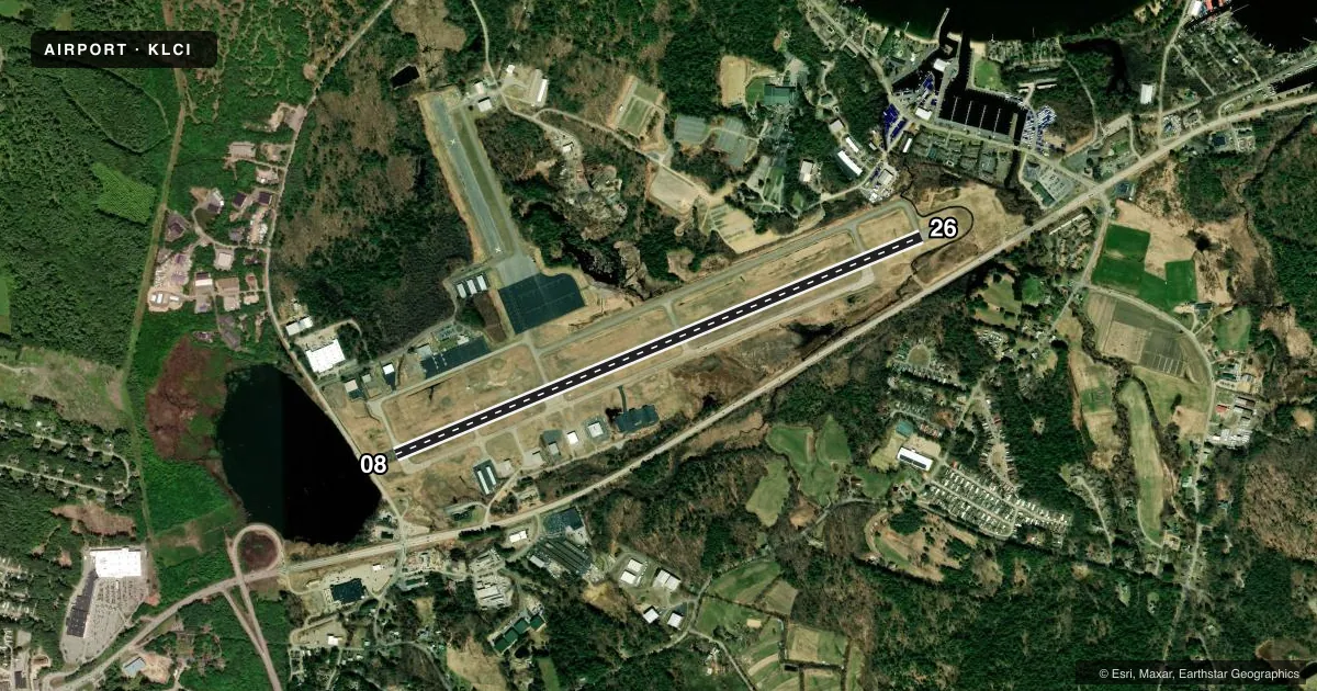
Runways & pattern
Full pagePattern entry · RWY 26
LEFT TRAFFICRunway end performance
| End | TORA | TODA | ASDA | LDA | VGSI | Approach lights | Obstruction |
|---|---|---|---|---|---|---|---|
| 08 | 5,890' | 5,890' | 5,646' | 5,646' | PAPI 4-box left(3°) | MALSR | 48', trees, 434' from thr, 598' R of cntrln, slope 4 |
| 26 | 5,890' | 5,890' | 5,530' | 5,286' | PAPI 4-box right(4°) | — | 50', trees, 559' from thr, 323' R of cntrln, slope 7 |
Declared distances in feet. TORA = takeoff run available, TODA = takeoff distance, ASDA = accelerate-stop, LDA = landing distance.
Airport sketch
Runways drawn to scale from FAA survey coordinates, rendered over satellite imagery. Not for navigation.
Approaches & charts
ILS · 1
Services on the field
Fuel grades, oxygen, maintenance, ramp storage and lighting — as declared to the FAA by the airport operator.
Fuel & services
- Fuel
- 100LLAA+
- Oxygen (bottled)
- HIGH/LOW
- Oxygen (bulk)
- HIGH/LOW
- Airframe repair
- Major
- Power plant repair
- Major
- Other services
- CHTR,INSTR,RNTL,SALES
Ramp & ground
- Transient storage
- Tie-down
- Hangar
- Landing fee
- No fee published
- Customs
- Not available
- Lighting schedule
- SEE RMK
- Beacon schedule
- SS-SR
- Beacon
- White / Green (civil land)(WG)
- Wind indicator
- Lighted
- Segmented circle
- Yes
Fuel & FBOs
Cheapest 100LL and Jet A on the field and nearby. Always confirm with the FBO before taxi.
Airport notes
Surface conditions, obstructions, local procedures, lighting outages and other notes published with each FAA cycle.
General notes
- WILDLIFE ON & INVOF ARPT.
- TWY A CLSD TO ACFT WITH WINGSPANS GTR THAN 49 FT.
- FOR CD CTC BOSTON APCH AT 603-594-5552.
- CTN: LOCKE'S HILL 500 FT TRRN MKD WITH 2 RED BCNS, 1.2 NM E OF ARPT.
- CTN: RISING TRRN 5000 FT S OF ARPT.
- RWY 26 DSGND CALM WIND RWY.
- VOLUNTARY NOISE ABATEMENT PROC: AVOID OVERFLYING VARNEY POINT 1 NM NE OF ARPT. SEE LACONIA ARPT WEBSITE FOR DTLS.
Lighting notes
- DUSK-DAWN. ACTVT MALSR RWY 08; REIL RWY 26; HIRL RWY 08/26; WINDSOCK LGTS - CTAF.
Fuel notes
- 100LL100LL AVBL 24 HRS WITH CREDIT CARD.
- AFOR JET A AFT HRS CALL FBOS.
Approach & departure obstructions
- 26PAPI UNUSBL BYD 6 DEGS L OF CNTRLN.
VFR map & nearby airports
VFR sectional. Tap any ICAO chip to open that airport.
Key facts · KLCI
Answer card- ICAO
- KLCI
- Name
- LACONIA MUNI
- Location
- LACONIA, NEW HAMPSHIRE
- Elevation
- 545.4 ft MSL
- Traffic pattern altitude
- 1,545.4 ft MSL (1,000 AGL)
- Control tower
- Non-towered (use CTAF)
- Total runways
- 1
- Longest runway
- 08/26 · 5,890 ft
- Published ILS approaches
- 1
- Published frequencies
- 5
- Magnetic variation
- 16°
- Current flight rules
- VFR
- Current wind
- 260° at 3 kt
- Favored runway now
- RWY 26
Laconia Muni sits in Laconia, New Hampshire. Field elevation is 545.4 ft MSL. The airport has one runway. Runway 08/26 is 5,890 ft long. There is no control tower. Clearance delivery is handled through Boston Approach. The field has one ILS approach, published for runway 08. Pattern altitude is not published in the facts, so use the standard 1,000 ft AGL for light piston traffic unless the current FAA Chart Supplement says otherwise.
Two FBOs are on the field. Emerson Aviation carries 100LL, Jet A and Jet A Prist. Sky Bright carries 100LL, Jet A and Jet A Prist. 100LL is available 24 hours with a credit card. Jet A after hours requires a call to the FBOs. The airport also has published lighting notes. From dusk to dawn, runway 08 has medium intensity approach lighting with runway alignment indicator lights. Runway 26 has runway end identifier lights. High intensity runway lights are on both ends.
For first-time arrivals, watch the terrain. There is rising terrain 5,000 ft south of the airport. Locke's Hill is 1.2 NM east of the field. It is marked with two red beacons. The airport also has a voluntary noise abatement note to avoid overflying Varney Point, which is about 1 NM northeast of the airport. Taxiway A is closed to aircraft with wingspans greater than 49 ft. Runway 26 is the calm wind runway.