METAR & TAF 2B3
2B3 does not publish a METAR.
Showing the nearest reporting station: KVSF (HARTNESS STATE (SPRINGFIELD)) · 14.6 NM away. Conditions at 2B3 may differ.
METAR · KVSF
Observed 12:54Z
KVSF 271254Z AUTO 00000KT 10SM CLR 19/14 A2987 RMK AO2 SLP114 T01890139
- Wind
- 000° @ 0 kt
- Visibility
- 10 SM
- Temp / Dew
- 19°C / 14°C
- Altimeter
- 29.87 inHg
- Clouds
- CLR
- Density alt
- 1,514 ft
- Ceiling
- Unlimited
- Rules
- VFR
Airport info & contacts
Manager on record, flight service, ARTCC, attendance schedule and pattern altitude — published by the FAA and refreshed every 28 days.
Location
- From city
- 2 NM N
- VFR sectional
- NEW YORK
- ARTCC
- ZBW · BOSTON
- NOTAM facility
- BGR (NOTAM-D)
Airport manager
- Name
- HEATH MARSDEN
- Phone
- 978-886-0854
- Address
- 15 SUNAPEE ST, NEWPORT NH 03773
Flight service · Hours
- FSS BGR
- BANGOR1-800-WX-BRIEF
- Attendance
- IREG
Frequencies
Tap any row to copy the frequency to your clipboard.
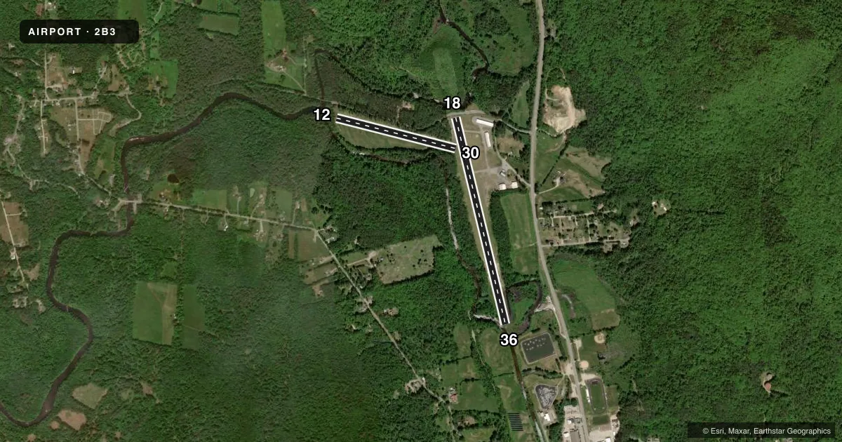
Runways & pattern
Full pagePattern entry · RWY 18
RIGHT TRAFFIC| Runway | Heading (°M) | Length | Surface | Traffic |
|---|---|---|---|---|
| 18/36 | 150° / 330° | 3,446 ft | ASPH | 18 R |
| 12/30 | 88° / 268° | 1,997 ft | TURF | 12 R |
Runway end performance
| End | TORA | TODA | ASDA | LDA | VGSI | Approach lights | Obstruction |
|---|---|---|---|---|---|---|---|
| 36 | — | — | — | — | — | — | 27', trees, 215' from thr, 70' R of cntrln, slope 0 |
| 12 | — | — | — | — | — | — | 83', trees, 19' from thr, 123' R of cntrln, slope 0 |
| 30 | — | — | — | — | — | — | 70', trees, 684' from thr, 158' R of cntrln, slope 9 |
Declared distances in feet. TORA = takeoff run available, TODA = takeoff distance, ASDA = accelerate-stop, LDA = landing distance.
Airport sketch
Runways drawn to scale from FAA survey coordinates, rendered over satellite imagery. Not for navigation.
Approaches & charts
Services on the field
Fuel grades, oxygen, maintenance, ramp storage and lighting — as declared to the FAA by the airport operator.
Fuel & services
- Fuel
- 100LL
- Oxygen (bottled)
- HIGH/LOW
- Oxygen (bulk)
- HIGH/LOW
- Airframe repair
- Major
- Power plant repair
- Major
- Other services
- AVNCS
Ramp & ground
- Transient storage
- Tie-down
- Hangar
- Landing fee
- No fee published
- Customs
- Not available
- Lighting schedule
- SS-SR
- Beacon schedule
- SS-SR
- Beacon
- White / Green (civil land)(WG)
- Wind indicator
- Lighted
- Segmented circle
- Yes
Fuel & FBOs
Cheapest 100LL and Jet A on the field and nearby. Always confirm with the FBO before taxi.
Airport notes
Surface conditions, obstructions, local procedures, lighting outages and other notes published with each FAA cycle.
General notes
- RWY 12/30 CLSD NOV 15 TO MAY 1.
- RWY 18, MT 981 FT MSL 2500 FT FM THR, 600 FT R.
- WILDLIFE ON & INVOF ARPT.
- NOISE ABATEMENT PROCS IN EFCT. AVOID NOISE SENSITIVE AREA 3000 FT NW OF ARPT. CTC AMGR AT 978-886-0854.
- PWRLINE MKD WITH ORANGE BALLS AT ARPT BDRY 900 FT FM AER 30.
- COURTESY BIKES AVBL, CAMP SITES AVBL ON ARPT.
- FOR CD CTC BOSTON ARTCC AT 603-879-6859.
Lighting notes
- ROTG BCN OTS INDEFLY.
Fuel notes
- 100LLSELF SVC FUEL AVBL 24 HRS WITH CREDIT CARD.
Runway surface & condition
- 18/36NON-STD FOR SPACING. RWY 18 END INDCR NON-STD REFLECTOR BARS.
Approach & departure obstructions
- 18ROAD 45 FT FM END OF RWY.
- 3610 FT LOW GROWTH AND TREES 57 FT FM RWY END.
- 12CTLG OBSTN EXCEEDS A 45 DEG SLP.
- 36CTLG OBSTN EXCEEDS A 45 DEG SLP.
Other notes
- ESTAB PRIOR TO 1959.
VFR map & nearby airports
VFR sectional. Tap any ICAO chip to open that airport.
Key facts · 2B3
Answer card- ICAO
- 2B3
- Name
- PARLIN FLD
- Location
- NEWPORT, NEW HAMPSHIRE
- Elevation
- 783.9 ft MSL
- Traffic pattern altitude
- 1,783.9 ft MSL (1,000 AGL)
- Control tower
- Non-towered (use CTAF)
- Total runways
- 2
- Longest runway
- 18/36 · 3,446 ft
- Published ILS approaches
- 0
- Published frequencies
- 2
- Magnetic variation
- 16°
- Current flight rules
- VFR
- Current wind
- 000° at 0 kt
- Favored runway now
- –
Parlin Field is in Newport, New Hampshire. Field elevation is 783.9 ft MSL. The airport has two runways. The longest is runway 18/36 at 3,446 ft. Runway 12/30 is 1,997 ft turf. Runway 12/30 is closed from November 15 to May 1. There is no control tower. CTAF and UNICOM are both 122.8. No ILS approaches are published.
Pattern altitude is not published. Use 1,000 ft AGL for light piston planning unless the current Chart Supplement says otherwise. The field carries a few things a first-time pilot should know. A powerline with orange balls is marked near the airport boundary about 900 ft from runway 30. There is also a mountain near the runway 18 end. Wildlife has been reported on and near the airport. The rotating beacon is out of service indefinitely.
Parlin Field has one on-field FBO. Parlin Field carries AVGAS 100LL. Self-serve fuel is available 24 hours with a credit card. Courtesy bikes and camp sites are available on the airport. Runway 18/36 uses non-standard lighting spacing. The runway 18 end indicator has non-standard reflector bars. For clearance delivery, contact Boston ARTCC at 603-879-6859. If you need current noise or operating restrictions, check the current FAA Chart Supplement or call the airport operator before departure.