METAR & TAF 8B1
8B1 does not publish a METAR.
Showing the nearest reporting station: KAFN (JAFFREY AIRFIELD SILVER RANCH) · 16.0 NM away. Conditions at 8B1 may differ.
METAR · KAFN
Observed 12:52Z
KAFN 271252Z AUTO 18003KT 10SM CLR 20/11 A2989 RMK AO2 SLP121 T02000111
- Wind
- 180° @ 3 kt
- Visibility
- 10 SM
- Temp / Dew
- 20°C / 11°C
- Altimeter
- 29.89 inHg
- Clouds
- CLR
- Density alt
- 1,381 ft
- Ceiling
- Unlimited
- Rules
- VFR
Airport info & contacts
Manager on record, flight service, ARTCC, attendance schedule and pattern altitude — published by the FAA and refreshed every 28 days.
Location
- From city
- 3 NM S
- VFR sectional
- NEW YORK
- ARTCC
- ZBW · BOSTON
- NOTAM facility
- BGR (NOTAM-D)
Airport manager
- Name
- CHRIS CHESNEY
- Phone
- 603-827-4733
- Address
- 144 STORY RD, NELSON NH 03457
Flight service · Hours
- FSS BGR
- BANGOR1-800-WX-BRIEF
- Attendance
- Unattended
Frequencies
Tap any row to copy the frequency to your clipboard.
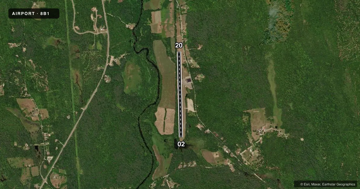
Runways & pattern
Full pagePattern entry · RWY 20
RIGHT TRAFFICRunway end performance
| End | TORA | TODA | ASDA | LDA | VGSI | Approach lights | Obstruction |
|---|---|---|---|---|---|---|---|
| 02 | — | — | — | — | — | — | 58', trees, 293' from thr, 101' R of cntrln, slope 1 |
| 20 | — | — | — | — | — | — | 70', trees, 232' from thr, 32' R of cntrln, slope 0 |
Declared distances in feet. TORA = takeoff run available, TODA = takeoff distance, ASDA = accelerate-stop, LDA = landing distance.
Airport sketch
Runways drawn to scale from FAA survey coordinates, rendered over satellite imagery. Not for navigation.
Approaches & charts
Services on the field
Fuel grades, oxygen, maintenance, ramp storage and lighting — as declared to the FAA by the airport operator.
Fuel & services
- Fuel
- Not available
- Oxygen (bottled)
- Not available
- Oxygen (bulk)
- Not available
- Airframe repair
- Not available
- Power plant repair
- Not available
Ramp & ground
- Transient storage
- Tie-down
- Landing fee
- No fee published
- Customs
- Not available
- Beacon
- White / Green (civil land)(WG)
- Wind indicator
- Yes
- Segmented circle
- No
Fuel & FBOs
Cheapest 100LL and Jet A on the field and nearby. Always confirm with the FBO before taxi.
Airport notes
Surface conditions, obstructions, local procedures, lighting outages and other notes published with each FAA cycle.
General notes
- WILDLIFE ON & INVOF ARPT.
- FOR CD CTC BOSTON APCH AT 603-594-5552.
Approach & departure obstructions
- 0250 FT GROVE OF TREES AT THR 65 FT L, 30 FT TREE 130 FT FM THR 85 FT R.
- 20+60 FT TREES AT THR 90 FT R.
- 02MARKINGS FADED.
- 20MARKINGS FADED.
- 02MARKINGS NON-STD.
- 02CTLG OBSTN EXCEEDS A 45 DEG SLP.
Other notes
- VFR OPS ONLY.
VFR map & nearby airports
VFR sectional. Tap any ICAO chip to open that airport.
Key facts · 8B1
Answer card- ICAO
- 8B1
- Name
- HAWTHORNE-FEATHER AIRPARK
- Location
- HILLSBORO, NEW HAMPSHIRE
- Elevation
- 600 ft MSL
- Traffic pattern altitude
- 1,600 ft MSL (1,000 AGL)
- Control tower
- Non-towered (use CTAF)
- Total runways
- 1
- Longest runway
- 02/20 · 3,260 ft
- Published ILS approaches
- 0
- Published frequencies
- 2
- Magnetic variation
- 16°
- Current flight rules
- VFR
- Current wind
- 180° at 3 kt
- Favored runway now
- RWY 20
Hawthorne-Feather Airpark sits in Hillsboro, New Hampshire. Field elevation is 600 ft MSL. The airport has one runway. Runway 02/20 is 3,260 ft long and paved with asphalt. There is no control tower. CTAF and UNICOM are both 122.8. No ILS approaches are published. Pattern altitude is not published, so use the standard 1,000 ft AGL for light piston traffic unless the current Chart Supplement says otherwise.
The on-field FBO is Hawthorne-Feather Airpark. Fuel grades are not reported in the facts, so call the field directly at (603) 588-6868 before you go if fuel matters for your trip. Published remarks say wildlife is present on and near the airport. They also flag faded runway 20 markings. They flag faded runway 02 markings. They also note non-standard markings on runway 02. The field is VFR only. For clearance delivery, Boston Approach is listed at 603-594-5552.
The runway environment deserves a close look before arrival. There are trees near both ends, including a 60 ft tree group near the threshold of runway 20 and a tree grove plus a single tree near runway 02. The published obstruction note for runway 02 also says the obstruction exceeds a 45 degree slope. With no tower and no ILS, this is a field where a current briefing and a careful visual setup matter.