METAR & TAF KAFN
Current METAR
Observed 15:52Z
KAFN 271552Z AUTO 00000KT 10SM CLR 26/13 A2986 RMK AO2 SLP111 T02610133
- Wind
- 000° @ 0 kt
- Visibility
- 10 SM
- Temp / Dew
- 26°C / 13°C
- Altimeter
- 29.86 inHg
- Clouds
- CLR
- Density alt
- 2,683 ft
- Ceiling
- Unlimited
- Rules
- VFR
Airport info & contacts
Manager on record, flight service, ARTCC, attendance schedule and pattern altitude — published by the FAA and refreshed every 28 days.
Location
- From city
- 1 NM SE
- VFR sectional
- NEW YORK
- ARTCC
- ZBW · BOSTON
- NOTAM facility
- AFN (NOTAM-D)
Airport manager
- Name
- HARVEY N SAWYER
- Phone
- 603-532-8870
- Address
- 190 TURNPIKE RD, JAFFERY AIRFIELD, JAFFREY NH 03452
Flight service · Hours
- FSS BGR
- BANGOR1-800-WX-BRIEF
- Attendance
- 0800-DUSK
Frequencies
Tap any row to copy the frequency to your clipboard.
Runways & pattern
Full pagePattern entry · RWY 16
LEFT TRAFFICRunway end performance
| End | TORA | TODA | ASDA | LDA | VGSI | Approach lights | Obstruction |
|---|---|---|---|---|---|---|---|
| 16 | — | — | — | — | — | — | 41', trees, 409' from thr, 133' R of cntrln, slope 5 |
| 34 | — | — | — | — | — | — | 67', trees, 401' from thr, 107' R of cntrln, slope 3 |
Declared distances in feet. TORA = takeoff run available, TODA = takeoff distance, ASDA = accelerate-stop, LDA = landing distance.
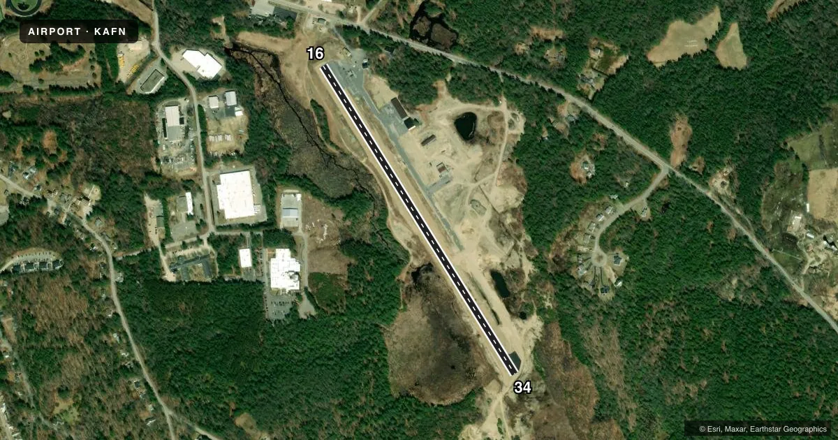
Airport sketch
Runways drawn to scale from FAA survey coordinates, rendered over satellite imagery. Not for navigation.
Approaches & charts
Services on the field
Fuel grades, oxygen, maintenance, ramp storage and lighting — as declared to the FAA by the airport operator.
Fuel & services
- Fuel
- 100LL
- Oxygen (bottled)
- Not available
- Oxygen (bulk)
- Not available
- Airframe repair
- Minor
- Power plant repair
- Minor
- Other services
- CHTR,INSTR,RNTL,SALES
Ramp & ground
- Transient storage
- Tie-down
- Hangar
- Landing fee
- No fee published
- Customs
- Not available
- Lighting schedule
- SEE RMK
- Wind indicator
- Yes
- Segmented circle
- No
Fuel & FBOs
Cheapest 100LL and Jet A on the field and nearby. Always confirm with the FBO before taxi.
Airport notes
Surface conditions, obstructions, local procedures, lighting outages and other notes published with each FAA cycle.
General notes
- ULTRALIGHT ACT ON ARPT.
- PARL TWY SERVES HNGR/RAMP ONLY - NO ACES TO RWY 34.
- WILDLIFE ON & INVOF ARPT.
- FOR CD CTC BOSTON ARTCC AT 603-879-6859.
- CALM WIND RWY IS RWY 34.
Lighting notes
- PPR FOR NSTD LIRL CALL 603-532-8870.
Runway surface & condition
- 16/34TGLS PROHIBITED.
- 16/34FIRST 582 FT RWY 34 NOT LGTD.
Approach & departure obstructions
- 34+6 FT TRRN/TREES 50 FT FM THR RISING TO +45 FT 200 FT FM THR.
- 34NSTD CNTRLN & DTHR.
- 34APCH SLP 20:1 TO DTHR.
- 3445 FT RISING TRRN/TREES 200+ FT FM THR.
Other notes
- THIS AIRPORT HAS BEEN SURVEYED BY THE NATIONAL GEODETIC SURVEY.
- ESTAB PRIOR 1959.
- 16/3450 FT CNTR PTN OF ENTR RWY IS ASPH, RMNG 42 FT PER SIDE IS TURF/GRVL FOR ENTR RWY LEN.
VFR map & nearby airports
VFR sectional. Tap any ICAO chip to open that airport.
Key facts · KAFN
Answer card- ICAO
- KAFN
- Name
- JAFFREY AIRFIELD SILVER RANCH
- Location
- JAFFREY, NEW HAMPSHIRE
- Elevation
- 1,039.5 ft MSL
- Traffic pattern altitude
- 2,039.5 ft MSL (1,000 AGL)
- Control tower
- Non-towered (use CTAF)
- Total runways
- 1
- Longest runway
- 16/34 · 2,982 ft
- Published ILS approaches
- 0
- Published frequencies
- 2
- Magnetic variation
- 14°
- Current flight rules
- VFR
- Current wind
- 000° at 0 kt
- Favored runway now
- –
Jaffrey Airfield Silver Ranch is in Jaffrey, New Hampshire. The field elevation is 1,039.5 ft MSL. It has one runway, 16/34, which is 2,982 ft long. The airport is non-towered. CTAF and UNICOM are both 122.8. No ILS approaches are published.
Pattern altitude is not published. Use 1,000 ft AGL for light piston traffic unless the current Chart Supplement or local guidance says otherwise. Silver Ranch Airpark is on the field. It carries 100LL. Call (603) 532-8870 for current service details before you go.
There are a few things to brief before arrival. Runway 34 has a displaced threshold and nonstandard centerline markings. The published remarks also call out terrain and trees near the 34 threshold. Wildlife is reported on and near the airport. A parallel taxiway serves the hangar and ramp only. It does not give runway access to 34. Calm wind runway is 34. The airport has been surveyed by the National Geodetic Survey. For clearance delivery, contact Boston ARTCC at 603-879-6859. If you need night lighting, prior permission is required for the nonstandard low intensity runway lights.