METAR & TAF KORE
Current METAR
Observed 10:52Z
KORE 271052Z AUTO 00000KT 10SM CLR 12/11 A2987 RMK AO2 SLP114 T01220111
- Wind
- 000° @ 0 kt
- Visibility
- 10 SM
- Temp / Dew
- 12°C / 11°C
- Altimeter
- 29.87 inHg
- Clouds
- CLR
- Density alt
- 391 ft
- Ceiling
- Unlimited
- Rules
- VFR
Airport info & contacts
Manager on record, flight service, ARTCC, attendance schedule and pattern altitude — published by the FAA and refreshed every 28 days.
Location
- From city
- 1 NM SE
- VFR sectional
- NEW YORK
- ARTCC
- ZBW · BOSTON
- NOTAM facility
- ORE (NOTAM-D)
Airport manager
- Name
- ADAM KLUMPP
- Phone
- 602-290-9035
- Address
- 80 AIRPORT ST, ORANGE MA 01364
Flight service · Hours
- FSS BDR
- BRIDGEPORT1-800-WX-BRIEF
- Attendance
- 0800-1700
Frequencies
Tap any row to copy the frequency to your clipboard.
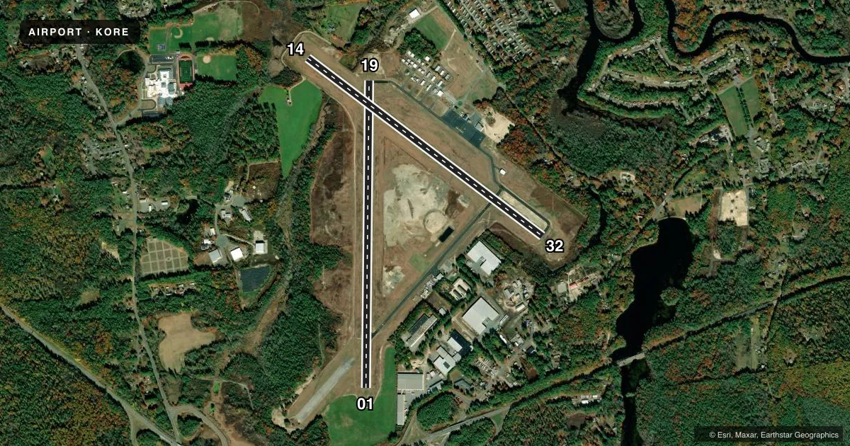
Runways & pattern
Full pagePattern entry · RWY 01
LEFT TRAFFIC| Runway | Heading (°M) | Length | Surface | Traffic |
|---|---|---|---|---|
| 01/19 | 346° / 166° | 5,002 ft | ASPH | Standard L |
| 14/32 | 112° / 292° | 4,800 ft | ASPH | Standard L |
Runway end performance
| End | TORA | TODA | ASDA | LDA | VGSI | Approach lights | Obstruction |
|---|---|---|---|---|---|---|---|
| 01 | — | — | — | — | PAPI 4-box left(3.4°) | — | 50', trees, 1200' from thr, 125' R of cntrln, slope 20 |
| 19 | — | — | — | — | — | — | 30', trees, 800' from thr, 135' R of cntrln, slope 20 |
| 14 | — | — | — | — | — | — | 20', trees, 700' from thr, 130' R of cntrln, slope 25 |
| 32 | — | — | — | — | — | — | 20', trees, 900' from thr, 125' R of cntrln, slope 34 |
Declared distances in feet. TORA = takeoff run available, TODA = takeoff distance, ASDA = accelerate-stop, LDA = landing distance.
Airport sketch
Runways drawn to scale from FAA survey coordinates, rendered over satellite imagery. Not for navigation.
Approaches & charts
Services on the field
Fuel grades, oxygen, maintenance, ramp storage and lighting — as declared to the FAA by the airport operator.
Fuel & services
- Fuel
- 100LLA
- Oxygen (bottled)
- Not available
- Oxygen (bulk)
- Not available
- Airframe repair
- Major
- Power plant repair
- Major
- Other services
- CHTR,INSTR,PAJA,RNTL,SALES
Ramp & ground
- Transient storage
- Tie-down
- Landing fee
- No fee published
- Customs
- Not available
- Lighting schedule
- SEE RMK
- Beacon schedule
- SS-SR
- Beacon
- White / Green (civil land)(WG)
- Wind indicator
- Yes
- Segmented circle
- Yes
Fuel & FBOs
Cheapest 100LL and Jet A on the field and nearby. Always confirm with the FBO before taxi.
Airport notes
Surface conditions, obstructions, local procedures, lighting outages and other notes published with each FAA cycle.
General notes
- PAJA WI 2 NM OF AIRFIELD, SFC TO 14500 FT MSL, 7 DAYS A WEEK, SR-SS, APR 1-NOV 30.
- WILDLIFE ON & INVOF ARPT.
- FOR CD CTC BOSTON ARTCC AT 603-879-6859.
- AFT HRS EMERG/FUEL PHONE CTC AMGR.
Lighting notes
- DUSK-DAWN. ACTVT MIRL RWYS 01/19 & 14/32 - CTAF. PAPI RWY 01 OPR CONSLY.
Fuel notes
- 100LL100LL FUEL SELF-SVC AVBL 24 HRS. AFT HRS EMERG/FUEL PHONE CTC 413-768-2672.
Runway surface & condition
- 01/19PCR VALUE: 290/F/A/X/T
- 14/32PCR VALUE: 290/F/B/X/T
Other notes
- ESTAB PRIOR TO 1959.
VFR map & nearby airports
VFR sectional. Tap any ICAO chip to open that airport.
Key facts · KORE
Answer card- ICAO
- KORE
- Name
- ORANGE MUNI
- Location
- ORANGE, MASSACHUSETTS
- Elevation
- 555.6 ft MSL
- Traffic pattern altitude
- 1,555.6 ft MSL (1,000 AGL)
- Control tower
- Non-towered (use CTAF)
- Total runways
- 2
- Longest runway
- 01/19 · 5,002 ft
- Published ILS approaches
- 0
- Published frequencies
- 2
- Magnetic variation
- 15°
- Current flight rules
- VFR
- Current wind
- 000° at 0 kt
- Favored runway now
- –
Orange Muni is in Orange, Massachusetts. The field elevation is 555.6 ft MSL. It has two asphalt runways. The longest is runway 01/19 at 5,002 ft. There is no control tower. CTAF and UNICOM are both 122.8.
No ILS approaches are published here. The pattern altitude is not published in the facts, so use the standard 1,000 ft AGL for light piston traffic unless the current Chart Supplement says otherwise. The airport has runway lighting from dusk to dawn. Medium intensity runway lights on 01/19 and 14/32 are activated by CTAF. The PAPI for runway 01 operates continuously.
Orange Municipal Airport is the on-field FBO. It carries 100LL and Jet A Prist. Self-serve 100LL is available 24 hours. For after-hours emergency or fuel service, use the published phone contacts before arrival.
A first-time pilot should also plan for wildlife on and near the airport. There is a prohibited area, J A W A, within 2 NM of the field from the surface to 14,500 ft MSL. It is active daily from sunrise to sunset, April 1 through November 30. Clearance delivery is handled through Boston ARTCC. Check the current Chart Supplement for any other local operating notes before you go.