METAR & TAF KFIT
Current METAR
Observed 22:52Z
KFIT 262252Z AUTO 12004KT 10SM CLR 25/08 A2987 RMK AO2 SLP115 T02500078
- Wind
- 120° @ 4 kt
- Visibility
- 10 SM
- Temp / Dew
- 25°C / 8°C
- Altimeter
- 29.87 inHg
- Clouds
- CLR
- Density alt
- 1,689 ft
- Ceiling
- Unlimited
- Rules
- VFR
Airport info & contacts
Manager on record, flight service, ARTCC, attendance schedule and pattern altitude — published by the FAA and refreshed every 28 days.
Location
- From city
- 3 NM SE
- VFR sectional
- NEW YORK
- Pattern altitude
- 1,002 ft AGL · 1,347 ft MSL
- ARTCC
- ZBW · BOSTON
- NOTAM facility
- FIT (NOTAM-D)
Airport manager
- Phone
- 978-345-9580
- Address
- FITCHBURG MUNICIPAL AIRPORT, 567 CRAWFORD ST, FITCHBURG MA 01420
Flight service · Hours
- FSS BDR
- BRIDGEPORT1-800-WX-BRIEF
- Attendance
- 0800-1700
Frequencies
Tap any row to copy the frequency to your clipboard.
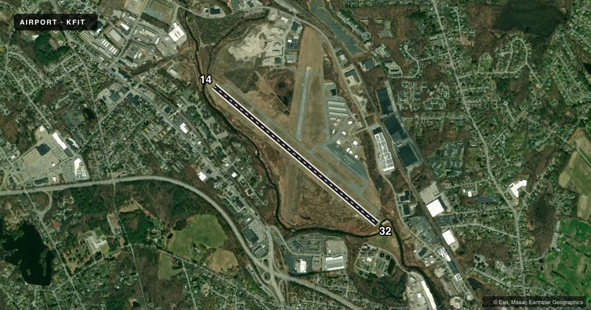
Runways & pattern
Full pagePattern entry · RWY 14
LEFT TRAFFICRunway end performance
| End | TORA | TODA | ASDA | LDA | VGSI | Approach lights | Obstruction |
|---|---|---|---|---|---|---|---|
| 14 | 5,001' | 5,001' | 4,701' | 4,538' | PAPI 4-box left(3°) | — | 50', trees, 600' from thr, 125' R of cntrln, slope 8 |
| 32 | 5,001' | 5,001' | 4,838' | 4,538' | PAPI 4-box left(3.5°) | — | 42', trees, 800' from thr, 125' R of cntrln, slope 14 |
Declared distances in feet. TORA = takeoff run available, TODA = takeoff distance, ASDA = accelerate-stop, LDA = landing distance.
Airport sketch
Runways drawn to scale from FAA survey coordinates, rendered over satellite imagery. Not for navigation.
Approaches & charts
Services on the field
Fuel grades, oxygen, maintenance, ramp storage and lighting — as declared to the FAA by the airport operator.
Fuel & services
- Fuel
- 100LLA+
- Oxygen (bottled)
- Not available
- Oxygen (bulk)
- Not available
- Airframe repair
- Major
- Power plant repair
- Major
- Other services
- AMB,AVNCS,GLD,INSTR,RNTL
Ramp & ground
- Transient storage
- Tie-down
- Hangar
- Landing fee
- Yes
- Customs
- Not available
- Lighting schedule
- SEE RMK
- Beacon schedule
- SS-SR
- Beacon
- White / Green (civil land)(WG)
- Wind indicator
- Yes
- Segmented circle
- Yes
Fuel & FBOs
Cheapest 100LL and Jet A on the field and nearby. Always confirm with the FBO before taxi.
Airport notes
Surface conditions, obstructions, local procedures, lighting outages and other notes published with each FAA cycle.
General notes
- WILDLIFE ON & INVOF ARPT.
- FOR CD CTC BOSTON APCH AT 603-594-5552.
- COLD TEMPERATURE AIRPORT. ALTITUDE CORRECTION REQUIRED AT OR BELOW -21C.
- NOISE SENSITIVE AREA: DEP ACFT CLIMB TO TPA BFR TURNING CROSSWIND.
Lighting notes
- ROTG BCN NOT AVBL DURG DALGT IFR CONDS.
- ACTVT REIL RWY 14 & 32; PAPI RWY 14 & 32; MIRL RWY 14/32 - 123.0.
Approach & departure obstructions
- 14PAPI UNUSBL BYD 5 DEGS L & R OF CNTRLN.
Other notes
- ESTAB PRIOR TO 1959.
- CTC OFC - CALCULATED BY TKOF GWT.
- GLDPWRD PARAGLIDERS.
VFR map & nearby airports
VFR sectional. Tap any ICAO chip to open that airport.
Key facts · KFIT
Answer card- ICAO
- KFIT
- Name
- FITCHBURG MUNI
- Location
- FITCHBURG, MASSACHUSETTS
- Elevation
- 344.5 ft MSL
- Traffic pattern altitude
- 1,346.5 ft MSL (1,002 AGL)
- Control tower
- Non-towered (use CTAF)
- Total runways
- 1
- Longest runway
- 14/32 · 5,001 ft
- Published ILS approaches
- 0
- Published frequencies
- 4
- Magnetic variation
- 15°
- Current flight rules
- VFR
- Current wind
- 120° at 4 kt
- Favored runway now
- RWY 14
Fitchburg Muni (KFIT) sits in Fitchburg, Massachusetts. Field elevation is 344.5 ft MSL. The airport has one runway, 14/32, which is 5,001 ft long with asphalt pavement. It is an untowered field. CTAF and UNICOM are both 122.7. Boston Approach handles the published approach and departure frequencies. No ILS approaches are published here.
Pattern altitude is 1,002 ft AGL. That puts the pattern at 1,346.5 ft MSL. The field has one on-field FBO, Fitchburg Municipal Airport. It carries 100LL and Jet A. Call (978) 345-9580 for current service details before you go.
A few published remarks matter here. The airport is a cold temperature field. Altitude correction is required at or below minus 21 degrees Celsius. Wildlife is reported on and near the airport. Departing aircraft must climb to pattern altitude before turning crosswind because of a noise-sensitive area. The PAPI on runway 14 is unusable beyond 5 degrees left or right of centerline. Powered paragliders are also present. If you need clearance delivery, contact Boston Approach at 603-594-5552. First-time pilots should brief the runway, the noise-sensitive departure and the lack of published ILS before arrival.