METAR & TAF KORH
Current METAR
Observed 12:54Z
KORH 271254Z 24004KT 10SM CLR 22/14 A2988 RMK AO2 SLP113 T02170139 $
- Wind
- 240° @ 4 kt
- Visibility
- 10 SM
- Temp / Dew
- 22°C / 14°C
- Altimeter
- 29.88 inHg
- Clouds
- CLR
- Density alt
- 2,141 ft
- Ceiling
- Unlimited
- Rules
- VFR
Airport info & contacts
Manager on record, flight service, ARTCC, attendance schedule and pattern altitude — published by the FAA and refreshed every 28 days.
Location
- From city
- 3 NM W
- VFR sectional
- NEW YORK
- ARTCC
- ZBW · BOSTON
- NOTAM facility
- ORH (NOTAM-D)
Airport manager
- Name
- ANDREW B DAVIS
- Phone
- 508-849-5550
- Address
- WORCESTER REGIONAL AIRPORT, 5 AIRPORT DR, WORCESTER MA 01602
Flight service · Hours
- FSS BDR
- BRIDGEPORT1-800-WX-BRIEF
- Attendance
- ALL
Frequencies
Tap any row to copy the frequency to your clipboard.
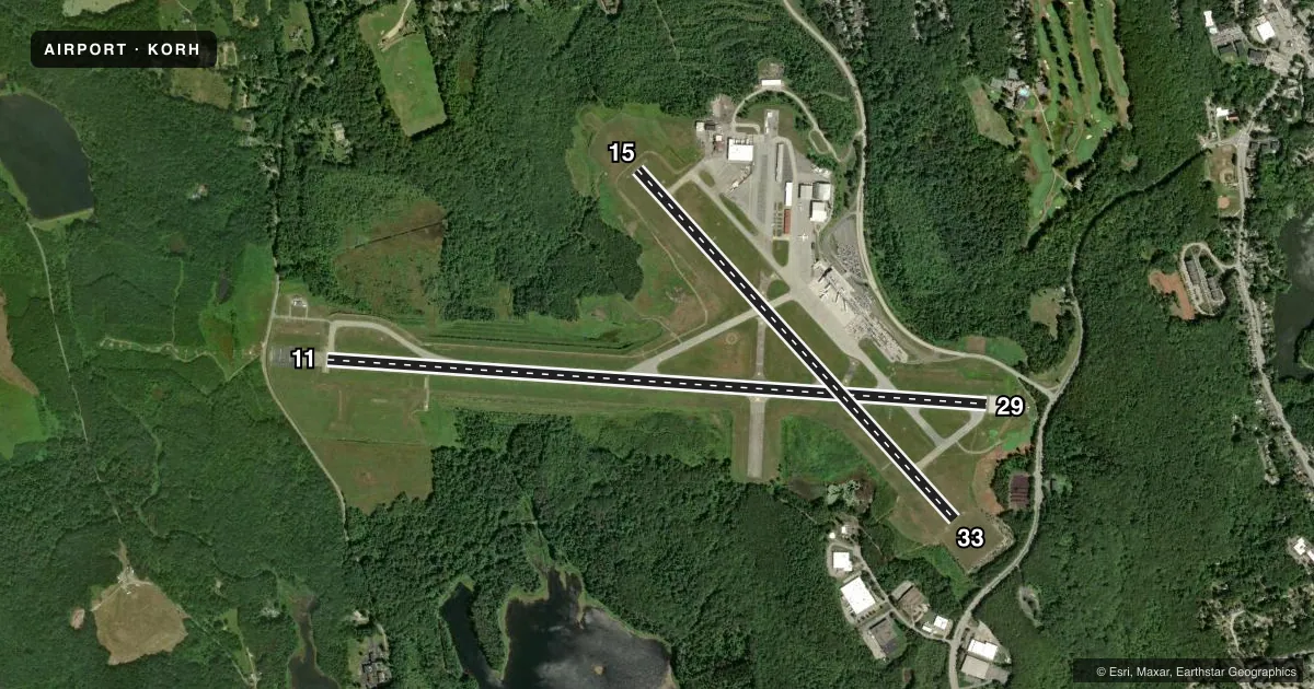
Runways & pattern
Full pagePattern entry · RWY 29
LEFT TRAFFIC| Runway | Heading (°M) | Length | Surface | Traffic |
|---|---|---|---|---|
| 11/29Favored | 79° / 259° | 7,001 ft | ASPH | Standard L |
| 15/33 | 123° / 303° | 5,000 ft | ASPH | Standard L |
Runway end performance
| End | TORA | TODA | ASDA | LDA | VGSI | Approach lights | Obstruction |
|---|---|---|---|---|---|---|---|
| 11 | 7,001' | 7,001' | 7,001' | 7,001' | PAPI 4-box right(3°) | ALSF2 | 110', hill, 4500' from thr, 0' R of cntrln, slope 39 |
| 29 | 7,001' | 7,001' | 7,001' | 7,001' | PAPI 4-box left(3°) | — | — |
| 15 | 5,000' | 5,000' | 5,000' | 5,000' | VASI 4-box left(3.6°) | — | 252', ant, 14000' from thr, 10' R of cntrln, slope 47 |
| 33 | 5,000' | 5,000' | 5,000' | 5,000' | PAPI 4-box left(3°) | — | — |
Declared distances in feet. TORA = takeoff run available, TODA = takeoff distance, ASDA = accelerate-stop, LDA = landing distance.
Airport sketch
Runways drawn to scale from FAA survey coordinates, rendered over satellite imagery. Not for navigation.
Approaches & charts
ILS · 2
Services on the field
Fuel grades, oxygen, maintenance, ramp storage and lighting — as declared to the FAA by the airport operator.
Fuel & services
- Fuel
- 100LLA
- Oxygen (bottled)
- Not available
- Airframe repair
- Major
- Power plant repair
- Major
- Other services
- AVNCS,CARGO,CHTR,INSTR,RNTL
Ramp & ground
- Transient storage
- Tie-down
- Hangar
- Landing fee
- Yes
- Customs
- Not available
- Lighting schedule
- SEE RMK
- Beacon schedule
- SS-SR
- Beacon
- White / Green (civil land)(WG)
- Wind indicator
- Yes
- Segmented circle
- Yes
Fuel & FBOs
Cheapest 100LL and Jet A on the field and nearby. Always confirm with the FBO before taxi.
Airport notes
Surface conditions, obstructions, local procedures, lighting outages and other notes published with each FAA cycle.
General notes
- WILDLIFE & BIRDS ON & INVOF ARPT.
- USE CTN FOR ARPT VEHICLES MNT CTAF & OPERG ON ARPT DURG NON-TWR HRS.
- TSNT ACFT CTC FBO ON 122.95 FOR SVCS.
- RWY GUARD LGTS INSTLD ON ALL TWY TO RWY INTXNS, RWY 11/29 ONLY.
- WHEN ATCT CLSD, FOR CD CTC BRADLEY APCH 860-386-3597.
Lighting notes
- ACTVT REIL RWY 15, 29 & 33; HIRL RWY 11/29; MIRL RWY 15/33 - CTAF.
Runway surface & condition
- 11/29PCR VALUE: 1400/F/D/W/T
- 15/33PCR VALUE: 470/F/D/W/T
Approach & departure obstructions
- 11RWY 11 ALSF-2 BECOMES SSALS PRESET ON MED INTST ONLY WHEN TWR CLSD.
- 15RWY 15 VASI UNUSBL BYD 9 DEG L OF CRS.
Arresting gear
- 11_EMASENGRD MTRLS ARST SYS 170 FT WID, 154 FT LEN, LCTD AT DER 11.
- 29_EMASENGRD MTRLS ARST SYS 170 FT WID, 300 FT LEN, LCTD AT DER 29.
Other notes
- FILED FOR RECORD PURPOSES ONLY.
- LDG FEE FOR MULTI-ENG ACFT & LRGR.
- 2 HRS ADVN NOTICE RQRD FOR CUST.
VFR map & nearby airports
VFR sectional. Tap any ICAO chip to open that airport.
Key facts · KORH
Answer card- ICAO
- KORH
- Name
- WORCESTER RGNL
- Location
- WORCESTER, MASSACHUSETTS
- Elevation
- 1,009 ft MSL
- Traffic pattern altitude
- 2,009 ft MSL (1,000 AGL)
- Control tower
- Towered · 0630-2100
- Total runways
- 2
- Longest runway
- 11/29 · 7,001 ft
- Published ILS approaches
- 2
- Published frequencies
- 12
- Magnetic variation
- 15°
- Current flight rules
- VFR
- Current wind
- 240° at 4 kt
- Favored runway now
- RWY 29
Worcester Rgnl sits in Worcester, Massachusetts. Field elevation is 1,009 ft MSL. The airport has 2 asphalt runways. The longest is 7,001 ft on 11/29. The tower is open daily from 0630 to 2100. Two ILS approaches are published. They serve runway ends 11 and 29.
Pattern altitude is not published. Use 1,000 ft AGL for light piston traffic unless ATC or the current Chart Supplement says otherwise. That puts the pattern at 2,009 ft MSL based on the field elevation in the facts. Atlantic Aviation is on the field. It carries 100LL and Jet A. Transient aircraft are told to contact the FBO on 122.95 for services.
This is a higher-elevation New England field with a busy mix of towered traffic. Expect to work the radio. Wildlife and birds are reported on and near the airport, so keep a sharp scan on departure and arrival. Runway 11/29 has high intensity lighting. Runway 15/33 uses medium intensity lighting via CTAF. Runway 29 also has an EMAS area at the departure end. Runway 11 has EMAS as well. When the tower is closed, clearance delivery goes through Bradley Approach at 860-386-3597. Two hours advance notice is required for customs. Check the current Chart Supplement for any published noise or curfew restrictions before flying into the field.