METAR & TAF KOWD
Current METAR
Observed 10:05Z
KOWD 271005Z AUTO 00000KT 3SM BR FEW002 BKN095 09/09 A2985 RMK AO2 T00940089
- Wind
- 000° @ 0 kt
- Visibility
- 3 SM
- Temp / Dew
- 9°C / 9°C
- Altimeter
- 29.85 inHg
- Clouds
- BKN
- Density alt
- -572 ft
- Ceiling
- 9,500 ft AGL
- Rules
- MVFR
Airport info & contacts
Manager on record, flight service, ARTCC, attendance schedule and pattern altitude — published by the FAA and refreshed every 28 days.
Location
- From city
- 2 NM E
- VFR sectional
- NEW YORK
- ARTCC
- ZBW · BOSTON
- NOTAM facility
- OWD (NOTAM-D)
Airport manager
- Name
- MARK RAYMOND
- Phone
- 781-255-5615
- Address
- 111 ACCESS RD, NORWOOD MA 02062
Flight service · Hours
- FSS BDR
- BRIDGEPORT1-800-WX-BRIEF
- Attendance
- MON - FRI · 0800-1700
Frequencies
Tap any row to copy the frequency to your clipboard.
Runways & pattern
Full pagePattern entry · RWY 17
LEFT TRAFFIC| Runway | Heading (°M) | Length | Surface | Traffic |
|---|---|---|---|---|
| 17/35 | 140° / 320° | 4,007 ft | ASPH | Standard L |
| 10/28 | 74° / 254° | 3,995 ft | ASPH | Standard L |
Runway end performance
| End | TORA | TODA | ASDA | LDA | VGSI | Approach lights | Obstruction |
|---|---|---|---|---|---|---|---|
| 17 | — | — | — | — | PAPI 4-box right(3°) | — | 26', trees, 850' from thr, 125' R of cntrln, slope 25 |
| 35 | — | — | — | — | PAPI 4-box left(3°) | MALSF | — |
| 10 | 3,995' | 3,995' | 3,782' | 2,795' | PAPI 4-box right(4°) | — | 40', trees, 1200' from thr, 125' R of cntrln, slope 25 |
| 28 | 3,995' | 3,995' | 3,808' | 3,595' | — | — | 40', trees, 1000' from thr, 125' R of cntrln, slope 20 |
Declared distances in feet. TORA = takeoff run available, TODA = takeoff distance, ASDA = accelerate-stop, LDA = landing distance.
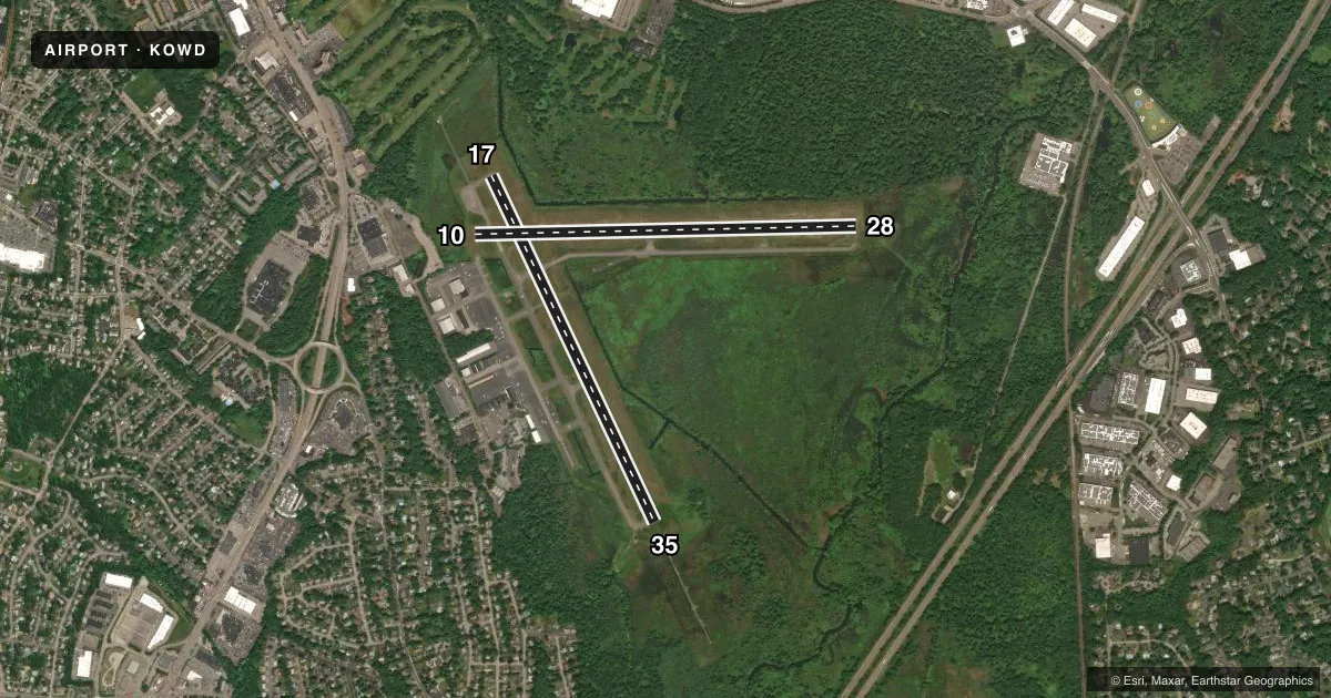
Airport sketch
Runways drawn to scale from FAA survey coordinates, rendered over satellite imagery. Not for navigation.
Approaches & charts
ILS · 1
Services on the field
Fuel grades, oxygen, maintenance, ramp storage and lighting — as declared to the FAA by the airport operator.
Fuel & services
- Fuel
- 100LLAA+
- Oxygen (bottled)
- Low pressure
- Oxygen (bulk)
- Not available
- Airframe repair
- Major
- Power plant repair
- Major
- Other services
- CHTR,INSTR,RNTL,SURV
Ramp & ground
- Transient storage
- Tie-down
- Hangar
- Landing fee
- No fee published
- Customs
- Not available
- Lighting schedule
- SEE RMK
- Beacon schedule
- SS-SR
- Beacon
- White / Green (civil land)(WG)
- Wind indicator
- Lighted
- Segmented circle
- No
Fuel & FBOs
Cheapest 100LL and Jet A on the field and nearby. Always confirm with the FBO before taxi.
Airport notes
Surface conditions, obstructions, local procedures, lighting outages and other notes published with each FAA cycle.
General notes
- 1199 FT /1349 FT MSL/ AND 1249 FT /1349 FT MSL/ TV TWR 8 NM NNW. 1063.5 FT /1184 FT MSL/ TWR 8.5 NM NNW.
- ALL ACFT EXCEEDING 87 EFF PERCEIVED NOISE LEVEL IN DBS OR 75 DBS, AS MEASURED IN PART 36 PROHIBITED FM USING ARPT.
- 125 FT FLAGPOLE 1 MI NW OF RWY 17 APCH.
- GATE 2 TXL LTD TO ACFT WITH WINGSPANS OF 50 FT OR LESS. GATE 3 TXL LTD TO ACFT WITH WINGSPANS OF 45 FT OR LESS.
- BIRD ACTVTY & WILDLIFE INVOF ARPT.
- SN REMOVAL EQUIP BLDG (ABUTTING SOUTH APRON).
- LDG FEES FOR TSNT FIXED-WING ACFT WITH MORE THAN 5000 LBS MAX TOG, AS WELL AS TSNT HELS REGARDLESS OF WT.
Lighting notes
- WHEN ATCT CLSD ACTVT MALSF RWY 35; PAPI RWYS 10, 17 & 35; MIRL 17/35 - CTAF.
Approach & departure obstructions
- 10APCH RATIO 50:1 TO DTHR.
Other notes
- FILED FOR RECORD PURPOSES ONLY.
VFR map & nearby airports
VFR sectional. Tap any ICAO chip to open that airport.
Key facts · KOWD
Answer card- ICAO
- KOWD
- Name
- NORWOOD MEML
- Location
- NORWOOD, MASSACHUSETTS
- Elevation
- 49.2 ft MSL
- Traffic pattern altitude
- 1,049.2 ft MSL (1,000 AGL)
- Control tower
- Towered · 0700-2000 1 NOV - 30 APR, 0700-2200 1 MAY - 31 OCT
- Total runways
- 2
- Longest runway
- 17/35 · 4,007 ft
- Published ILS approaches
- 1
- Published frequencies
- 9
- Magnetic variation
- 15°
- Current flight rules
- MVFR
- Current wind
- 000° at 0 kt
- Favored runway now
- –
Norwood Memorial Airport sits in Norwood, Massachusetts, southwest of Boston. Field elevation is 49.2 ft MSL. The airport has two asphalt runways. The longest is runway 17/35 at 4,007 ft. Runway 10/28 is 3,995 ft.
This is a towered airport. The tower is open 0700-2000 local from 1 Nov to 30 Apr. It is open 0700-2200 local from 1 May to 31 Oct. An ILS is available to runway 35. Pattern altitude is not published in the facts, so verify the current Chart Supplement before you fly. For light piston traffic, a standard 1,000 ft AGL pattern is often used. Confirm before departure.
Boston Executive is on the field. It carries 100LL and Jet A Prist. FlightLevel Aviation is also on the field. It carries 100LL, Jet A and Jet A Prist. The field has published noise limits. Aircraft above the listed noise thresholds are not allowed to use the airport. There are also taxiway wingspan limits at Gate 2 and Gate 3. A snow removal building sits by the south apron. Bird activity is also noted, so expect a careful scan on taxi, takeoff and final. When the tower is closed, use CTAF to activate runway 35 MALSR. Use it for the PAPIs on 10, 17 and 35. Use it for the MIRLs on 17 and 35.