METAR & TAF 1B6
1B6 does not publish a METAR.
Showing the nearest reporting station: KSFZ (NORTH CENTRAL STATE) · 11.2 NM away. Conditions at 1B6 may differ.
METAR · KSFZ
Observed 22:56Z
KSFZ 262256Z AUTO 07003KT 10SM BKN080 23/11 A2988 RMK AO2 SLP116 T02280106 $
- Wind
- 070° @ 3 kt
- Visibility
- 10 SM
- Temp / Dew
- 23°C / 11°C
- Altimeter
- 29.88 inHg
- Clouds
- BKN
- Density alt
- 1,343 ft
- Ceiling
- 8,000 ft AGL
- Rules
- VFR
Airport info & contacts
Manager on record, flight service, ARTCC, attendance schedule and pattern altitude — published by the FAA and refreshed every 28 days.
Location
- From city
- 3 NM SE
- VFR sectional
- NEW YORK
- ARTCC
- ZBW · BOSTON
- NOTAM facility
- BDR (NOTAM-D)
Airport manager
- Name
- JOSEPH MENFI
- Phone
- 508-478-1726
- Address
- HOPEDALE INDUSTRIAL PARK, HOPEDALE MA 01747
Flight service · Hours
- FSS BDR
- BRIDGEPORT1-800-WX-BRIEF
- Attendance
- MON-FRI · DAWN-DUSK
Frequencies
Tap any row to copy the frequency to your clipboard.
Runways & pattern
Full pagePattern entry · RWY 36
LEFT TRAFFICRunway end performance
| End | TORA | TODA | ASDA | LDA | VGSI | Approach lights | Obstruction |
|---|---|---|---|---|---|---|---|
| 18 | — | — | — | — | — | — | 60', trees, 470' from thr, 63' R of cntrln, slope 4 |
| 36 | — | — | — | — | — | — | 60', trees, 325' from thr, 100' R of cntrln, slope 2 |
Declared distances in feet. TORA = takeoff run available, TODA = takeoff distance, ASDA = accelerate-stop, LDA = landing distance.
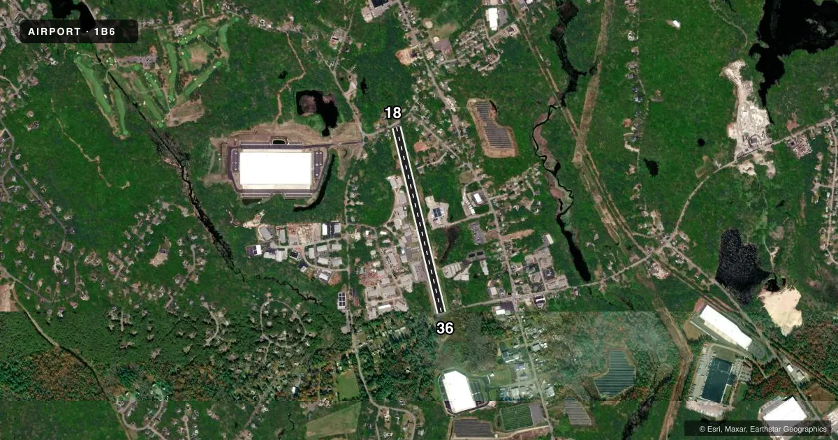
Airport sketch
Runways drawn to scale from FAA survey coordinates, rendered over satellite imagery. Not for navigation.
Approaches & charts
Services on the field
Fuel grades, oxygen, maintenance, ramp storage and lighting — as declared to the FAA by the airport operator.
Fuel & services
- Fuel
- Not available
- Oxygen (bottled)
- Not available
- Oxygen (bulk)
- Not available
- Airframe repair
- Not available
- Power plant repair
- Not available
Ramp & ground
- Transient storage
- Tie-down
- Landing fee
- No fee published
- Customs
- Not available
- Lighting schedule
- SEE RMK
- Wind indicator
- Yes
- Segmented circle
- No
Fuel & FBOs
Cheapest 100LL and Jet A on the field and nearby. Always confirm with the FBO before taxi.
Airport notes
Surface conditions, obstructions, local procedures, lighting outages and other notes published with each FAA cycle.
General notes
- ARPT CLSD TO TSNT ACFT SS-SR.
- RWY 18, TWO STORY HOUSE 27 FT AGL (291 FT MSL) LCTD APRXLY 400 FT NW RWY THR.
- ARPT CLSD TO TSNT STUDENT TRNG.
- ARPT CLSD TO JETS & NIGHT LDGS EXC PPR CALL 508-478-1726.
- WILDLIFE INVOF ARPT.
- FOR CD CTC BRADLEY APCH AT 860-386-3597.
Lighting notes
- DUSK-2200.
Approach & departure obstructions
- 18ROAD 30 FT N FM RWY END.
- 36ROAD 20 FT FM RWY END.
- 36APCH RATIO 3:1 AT DTHR.
Other notes
- THIS AIRPORT HAS BEEN SURVEYED BY THE NATIONAL GEODETIC SURVEY.
- ESTABD PRIOR TO 1959.
VFR map & nearby airports
VFR sectional. Tap any ICAO chip to open that airport.
Key facts · 1B6
Answer card- ICAO
- 1B6
- Name
- HOPEDALE INDUSTRIAL PARK
- Location
- HOPEDALE, MASSACHUSETTS
- Elevation
- 269 ft MSL
- Traffic pattern altitude
- 1,269 ft MSL (1,000 AGL)
- Control tower
- Non-towered (use CTAF)
- Total runways
- 1
- Longest runway
- 18/36 · 3,172 ft
- Published ILS approaches
- 0
- Published frequencies
- 3
- Magnetic variation
- 16°
- Current flight rules
- VFR
- Current wind
- 070° at 3 kt
- Favored runway now
- RWY 36
Hopedale Industrial Park is in Hopedale, Massachusetts. Field elevation is 269 ft MSL. The airport has one runway. Runway 18/36 is 3,172 ft of asphalt, with magnetic headings of 166° and 346°. This is a non-towered field. CTAF and UNICOM are both 122.8. Bradley Approach is on 119.0 for approach and departure work.
No ILS approaches are published here. Pattern altitude is not published. Use the standard 1,000 ft AGL pattern for light piston traffic unless the current Chart Supplement or local procedures say otherwise. The field is closed to transient aircraft from sunset to sunrise. Lighting is available from dusk to 2200. The airport is also closed to jets and night landings unless you have prior permission. Call 508-478-1726 before planning that kind of arrival.
There are no on-field FBOs listed in the facts. Contact the airport operator directly before arrival, or call the field on CTAF or UNICOM for current service status. A few published remarks matter on the ground. There is a road close to the end of runway 18. There is also a road near the end of runway 36. The published remarks note a 3 to 1 approach ratio at the displaced threshold of runway 36. Wildlife is in the area. If you are filing in or need clearance delivery, Bradley Approach can be reached at 860-386-3597.