METAR & TAF 3B3
3B3 does not publish a METAR.
Showing the nearest reporting station: KFIT (FITCHBURG MUNI) · 7.8 NM away. Conditions at 3B3 may differ.
METAR · KFIT
Observed 09:52Z
KFIT 270952Z AUTO 00000KT 10SM CLR 11/09 A2985 RMK AO2 SLP109 T01060089
- Wind
- 000° @ 0 kt
- Visibility
- 10 SM
- Temp / Dew
- 11°C / 9°C
- Altimeter
- 29.85 inHg
- Clouds
- CLR
- Density alt
- 176 ft
- Ceiling
- Unlimited
- Rules
- VFR
Airport info & contacts
Manager on record, flight service, ARTCC, attendance schedule and pattern altitude — published by the FAA and refreshed every 28 days.
Location
- From city
- 2 NM SW
- VFR sectional
- NEW YORK
- ARTCC
- ZBW · BOSTON
- NOTAM facility
- BDR (NOTAM-D)
Airport manager
- Name
- THOMAS DUFFY
- Phone
- 978-422-8860
- Address
- 121 GREENLAND RD, STERLING MA 01564
Flight service · Hours
- FSS BDR
- BRIDGEPORT1-800-WX-BRIEF
- Attendance
- THU-SUN · 0800-1800
Frequencies
Tap any row to copy the frequency to your clipboard.
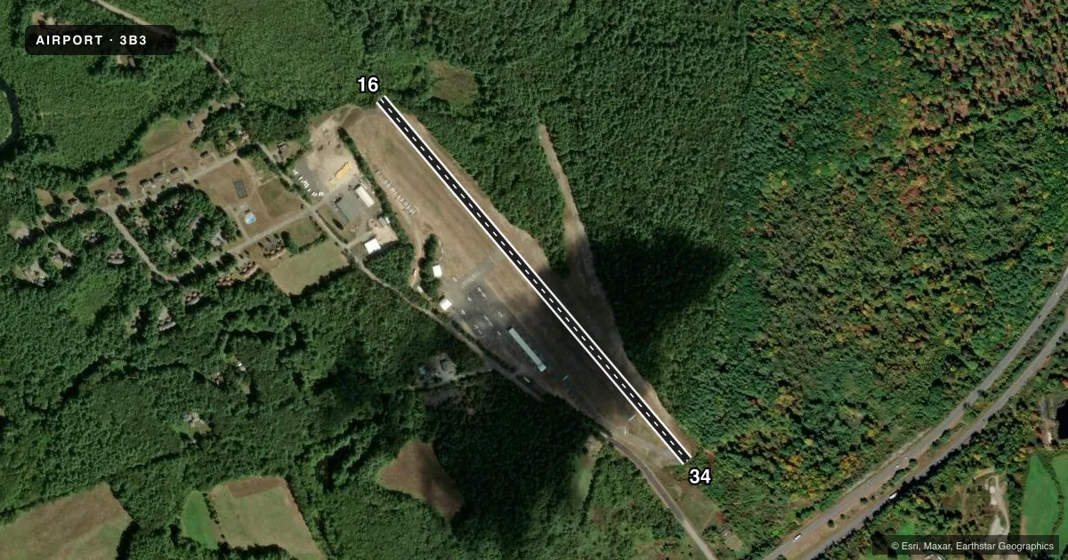
Runways & pattern
Full pagePattern entry · RWY 16
LEFT TRAFFICRunway end performance
| End | TORA | TODA | ASDA | LDA | VGSI | Approach lights | Obstruction |
|---|---|---|---|---|---|---|---|
| 16 | — | — | — | — | — | — | 50', trees, 400' from thr, 125' R of cntrln, slope 4 |
| 34 | — | — | — | — | — | — | 100', tree, 600' from thr, 53' R of cntrln, slope 4 |
Declared distances in feet. TORA = takeoff run available, TODA = takeoff distance, ASDA = accelerate-stop, LDA = landing distance.
Airport sketch
Runways drawn to scale from FAA survey coordinates, rendered over satellite imagery. Not for navigation.
Approaches & charts
Services on the field
Fuel grades, oxygen, maintenance, ramp storage and lighting — as declared to the FAA by the airport operator.
Fuel & services
- Fuel
- 100LL
- Oxygen (bottled)
- Not available
- Oxygen (bulk)
- Not available
- Airframe repair
- Minor
- Power plant repair
- Minor
- Other services
- GLD,INSTR,RNTL
Ramp & ground
- Transient storage
- Tie-down
- Landing fee
- No fee published
- Customs
- Not available
- Lighting schedule
- SEE RMK
- Beacon
- White / Green (civil land)(WG)
- Wind indicator
- Yes
- Segmented circle
- No
Fuel & FBOs
Cheapest 100LL and Jet A on the field and nearby. Always confirm with the FBO before taxi.
Airport notes
Surface conditions, obstructions, local procedures, lighting outages and other notes published with each FAA cycle.
General notes
- GLDR OPS INVOF ARPT SR-SS DLY.
- WILDLIFE INVOF ARPT.
- FOR CD CTC BRADLEY APCH AT 860-386-3597.
- GLDRS ONLY R TFC RWY 16.
Lighting notes
- ACTVT LIRL RWY 16/34 & ROTG BCN - CTAF.
Runway surface & condition
- 16/34NON-STD LIRL; FIRST 190 FT RWY 16 UNLGTD; FIRST 240 FT RWY 34 UNLGTD.
Approach & departure obstructions
- 16APCH RATIO 11:1 TO DSPLCD THR.
- 34APCH RATIO 6:1 TO DSPLCD THR.
Other notes
- ESTAB PRIOR TO 1959.
- INTENSIVE GLDR ACTVT ON WKENDS.
VFR map & nearby airports
VFR sectional. Tap any ICAO chip to open that airport.
Key facts · 3B3
Answer card- ICAO
- 3B3
- Name
- STERLING
- Location
- STERLING, MASSACHUSETTS
- Elevation
- 459 ft MSL
- Traffic pattern altitude
- 1,459 ft MSL (1,000 AGL)
- Control tower
- Non-towered (use CTAF)
- Total runways
- 1
- Longest runway
- 16/34 · 3,086 ft
- Published ILS approaches
- 0
- Published frequencies
- 1
- Magnetic variation
- 15°
- Current flight rules
- VFR
- Current wind
- 000° at 0 kt
- Favored runway now
- –
Sterling Airport sits in Sterling, Massachusetts at 459 ft MSL. It has one runway, 16/34, which is 3,086 ft long. There is no control tower. CTAF is 122.9. No ILS approaches are published here.
The pattern altitude is not published. Use 1,000 ft AGL for light piston traffic unless the current Chart Supplement says otherwise. Sterling Air is on the field and carries AVGAS 100LL. Call (978) 422-8860 for current service details before you go.
This is a glider-active field. Gliders are the only right traffic for runway 16. Glider operations run from sunrise to sunset daily. Weekend activity can be heavy. Wildlife is also reported in the area. Runway 16/34 has low-intensity lighting that is controlled by CTAF. The first 190 ft of runway 16 and the first 240 ft of runway 34 are unlighted. That matters on night arrivals and during short final planning.
The airport is in central Massachusetts. Expect a non-towered environment with mixed traffic. If you need clearance delivery, contact Bradley Approach at 860-386-3597. Check the current Chart Supplement for any noise or curfew restrictions before flying into the field.