METAR & TAF 3B0
3B0 does not publish a METAR.
Showing the nearest reporting station: KORH (WORCESTER RGNL) · 12.3 NM away. Conditions at 3B0 may differ.
METAR · KORH
Observed 14:54Z
KORH 271454Z 23003KT 10SM CLR 24/15 A2987 RMK AO2 SLP111 T02440150 58001 $
- Wind
- 230° @ 3 kt
- Visibility
- 10 SM
- Temp / Dew
- 24°C / 15°C
- Altimeter
- 29.87 inHg
- Clouds
- CLR
- Density alt
- 2,009 ft
- Ceiling
- Unlimited
- Rules
- VFR
Airport info & contacts
Manager on record, flight service, ARTCC, attendance schedule and pattern altitude — published by the FAA and refreshed every 28 days.
Location
- From city
- 2 NM N
- VFR sectional
- NEW YORK
- ARTCC
- ZBW · BOSTON
- NOTAM facility
- BDR (NOTAM-D)
Airport manager
- Name
- NORMAN MEIKLE
- Phone
- 508-764-2155
- Address
- 220 AIRPORT ACCESS RD, SOUTHBRIDGE MA 01550
Flight service · Hours
- FSS BDR
- BRIDGEPORT1-800-WX-BRIEF
- Attendance
- 0800-DUSK
Frequencies
Tap any row to copy the frequency to your clipboard.
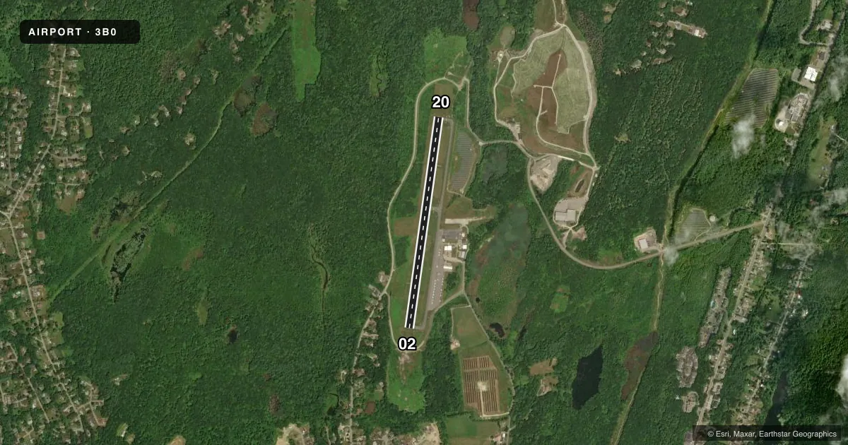
Runways & pattern
Full pagePattern entry · RWY 20
LEFT TRAFFICRunway end performance
| End | TORA | TODA | ASDA | LDA | VGSI | Approach lights | Obstruction |
|---|---|---|---|---|---|---|---|
| 02 | — | — | — | — | PAPI 4-box left(3°) | — | 23', trees, 1000' from thr, 125' R of cntrln, slope 34 |
| 20 | — | — | — | — | PAPI 4-box left(3.5°) | — | 52', trees, 2000' from thr, slope 34 |
Declared distances in feet. TORA = takeoff run available, TODA = takeoff distance, ASDA = accelerate-stop, LDA = landing distance.
Airport sketch
Runways drawn to scale from FAA survey coordinates, rendered over satellite imagery. Not for navigation.
Approaches & charts
Services on the field
Fuel grades, oxygen, maintenance, ramp storage and lighting — as declared to the FAA by the airport operator.
Fuel & services
- Fuel
- 100LL
- Oxygen (bottled)
- Not available
- Oxygen (bulk)
- Not available
- Airframe repair
- Major
- Power plant repair
- Major
- Other services
- INSTR,RNTL
Ramp & ground
- Transient storage
- Tie-down
- Landing fee
- No fee published
- Customs
- Not available
- Lighting schedule
- SEE RMK
- Beacon schedule
- SS-SR
- Beacon
- White / Green (civil land)(WG)
- Wind indicator
- Yes
- Segmented circle
- Yes
Fuel & FBOs
Cheapest 100LL and Jet A on the field and nearby. Always confirm with the FBO before taxi.
Airport notes
Surface conditions, obstructions, local procedures, lighting outages and other notes published with each FAA cycle.
General notes
- FOR CD CTC BRADLEY APCH AT 860-386-3597.
Lighting notes
- ACTVT REIL RWY 02 & 20; PAPI RWY 02 & 20; MIRL RWY 02/20 - CTAF.
Other notes
- THIS AIRPORT HAS BEEN SURVEYED BY THE NATIONAL GEODETIC SURVEY.
- ESTAB PRIOR TO 1959.
VFR map & nearby airports
VFR sectional. Tap any ICAO chip to open that airport.
Key facts · 3B0
Answer card- ICAO
- 3B0
- Name
- SOUTHBRIDGE MUNI
- Location
- SOUTHBRIDGE, MASSACHUSETTS
- Elevation
- 698.8 ft MSL
- Traffic pattern altitude
- 1,698.8 ft MSL (1,000 AGL)
- Control tower
- Non-towered (use CTAF)
- Total runways
- 1
- Longest runway
- 02/20 · 3,501 ft
- Published ILS approaches
- 0
- Published frequencies
- 4
- Magnetic variation
- 14°
- Current flight rules
- VFR
- Current wind
- 230° at 3 kt
- Favored runway now
- RWY 20
Southbridge Muni sits in Southbridge, Massachusetts. The field elevation is 698.8 ft MSL. It has one runway. Runway 02/20 is 3,501 ft of asphalt. There is no control tower. Use CTAF 122.8 for local traffic. The published pattern altitude is not listed. Use 1,000 ft AGL for light piston operations unless the current Chart Supplement says otherwise.
No ILS approaches are published here. The airport does have runway end identifier lights, PAPI on both ends and medium intensity runway lighting on 02/20. That helps for night work. The airport also uses the common traffic advisory frequency. For clearance delivery, Bradley Approach handles it at 860-386-3597.
Southbridge Municipal Airport is the on-field FBO. It carries 100LL. Call (508) 764-2155 before you go if you need current ramp or service details. The airport was established before 1959. It has also been surveyed by the National Geodetic Survey. For a first visit, plan for a small non-towered field with one short asphalt runway and no published ILS. Check the current Chart Supplement for any local procedures before arrival.