METAR & TAF KLZD
KLZD does not publish a METAR.
Showing the nearest reporting station: KIJD (WINDHAM) · 13.3 NM away. Conditions at KLZD may differ.
METAR · KIJD
Observed 11:52Z
KIJD 271152Z AUTO 00000KT 10SM CLR 16/12 A2987 RMK AO2 SLP112 T01560122 10156 20117 51006
- Wind
- 000° @ 0 kt
- Visibility
- 10 SM
- Temp / Dew
- 16°C / 12°C
- Altimeter
- 29.87 inHg
- Clouds
- CLR
- Density alt
- 477 ft
- Ceiling
- Unlimited
- Rules
- VFR
Airport info & contacts
Manager on record, flight service, ARTCC, attendance schedule and pattern altitude — published by the FAA and refreshed every 28 days.
Location
- From city
- 2 NM NW
- VFR sectional
- NEW YORK
- ARTCC
- ZBW · BOSTON
- NOTAM facility
- BDR (NOTAM-D)
Airport manager
- Name
- ROBERT PELLEGRINO
- Phone
- 860-982-2443
- Address
- CONNECTICUT AIRPORT AUTHORITY, 239 MAXIM RD, HARTFORD CT 06114
Flight service · Hours
- FSS BDR
- BRIDGEPORT1-800-WX-BRIEF
- Attendance
- UNATTENDED
Frequencies
Tap any row to copy the frequency to your clipboard.
Runways & pattern
Full pagePattern entry · RWY 13
LEFT TRAFFICRunway end performance
| End | TORA | TODA | ASDA | LDA | VGSI | Approach lights | Obstruction |
|---|---|---|---|---|---|---|---|
| 13 | — | — | — | — | — | — | 27', tree, 509' from thr, 155' R of cntrln, slope 11 |
| 31 | — | — | — | — | — | — | 90', tree, 1550' from thr, 280' R of cntrln, slope 14 |
Declared distances in feet. TORA = takeoff run available, TODA = takeoff distance, ASDA = accelerate-stop, LDA = landing distance.
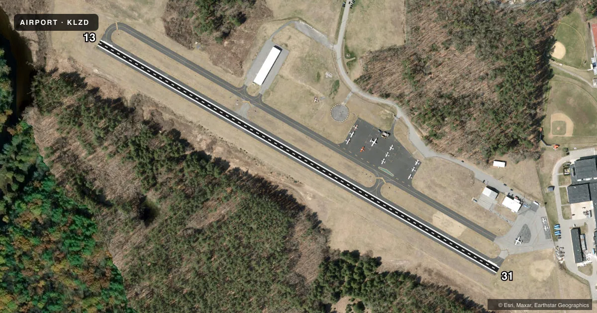
Airport sketch
Runways drawn to scale from FAA survey coordinates, rendered over satellite imagery. Not for navigation.
Approaches & charts
Services on the field
Fuel grades, oxygen, maintenance, ramp storage and lighting — as declared to the FAA by the airport operator.
Fuel & services
- Fuel
- 100LL
- Oxygen (bottled)
- Not available
- Oxygen (bulk)
- Not available
- Airframe repair
- Major
- Power plant repair
- Major
- Other services
- GLD,PAJA,TOW
Ramp & ground
- Transient storage
- Tie-down
- Landing fee
- No fee published
- Customs
- Not available
- Lighting schedule
- SEE RMK
- Beacon schedule
- SS-SR
- Beacon
- White / Green (civil land)(WG)
- Wind indicator
- Yes
- Segmented circle
- Yes
Fuel & FBOs
Cheapest 100LL and Jet A on the field and nearby. Always confirm with the FBO before taxi.
Airport notes
Surface conditions, obstructions, local procedures, lighting outages and other notes published with each FAA cycle.
General notes
- DEER ON & INVOF ARPT.
- FOR CD CTC PROVIDENCE APCH AT 401-738-8945, WHEN APCH CLSD CTC BOSTON ARTCC AT 603-879-6859.
Lighting notes
- ACTVT REIL RWY 31; MIRL RWY 13/31 - CTAF.
Fuel notes
- 100LLSELF SVC FUEL, CREDIT CARD RQRD: VISA, MASTER-CARD.
Other notes
- VFR USE ONLY.
- LDG FEE FOR BUS/CORPORATE & REVENUE PRODUCING ACFT.
- PAJAEXTSV PAJA SR-SS MAY-OCT.
VFR map & nearby airports
VFR sectional. Tap any ICAO chip to open that airport.
Key facts · KLZD
Answer card- ICAO
- KLZD
- Name
- DANIELSON
- Location
- DANIELSON, CONNECTICUT
- Elevation
- 238 ft MSL
- Traffic pattern altitude
- 1,238 ft MSL (1,000 AGL)
- Control tower
- Non-towered (use CTAF)
- Total runways
- 1
- Longest runway
- 13/31 · 2,700 ft
- Published ILS approaches
- 0
- Published frequencies
- 4
- Magnetic variation
- 14°
- Current flight rules
- VFR
- Current wind
- 000° at 0 kt
- Favored runway now
- –
Danielson Airport sits in Danielson, Connecticut. The field elevation is 238 ft MSL. It has one runway, 13/31, at 2,700 ft of asphalt. There is no control tower. Pattern altitude is not published, so plan on the standard 1,000 ft AGL for light piston traffic unless the current Chart Supplement says otherwise.
No ILS approaches are published here. This is a VFR-only field per the published remarks, so check the weather and your alternates before you launch. The airport uses CTAF 123.0 and UNICOM 123.0. For clearance delivery, Providence Approach is the published contact. When Approach is closed, Boston ARTCC is the backup contact.
Danielson Airport is the on-field FBO. It reports self-service 100LL. Credit card use is required. The published remarks also note that extensive passenger and crew services are available from sunrise to sunset from May through October. Runway 31 has REILs. Medium intensity runway lights are available on runways 13 and 31. They are controlled by CTAF. Deer are reported on and near the airport. Keep a sharp scan on taxi, takeoff and final.